Page 130 of 276
Re: FORGOTTEN CORNERS
Posted: 30 May 2018, 04:22
by Stanley
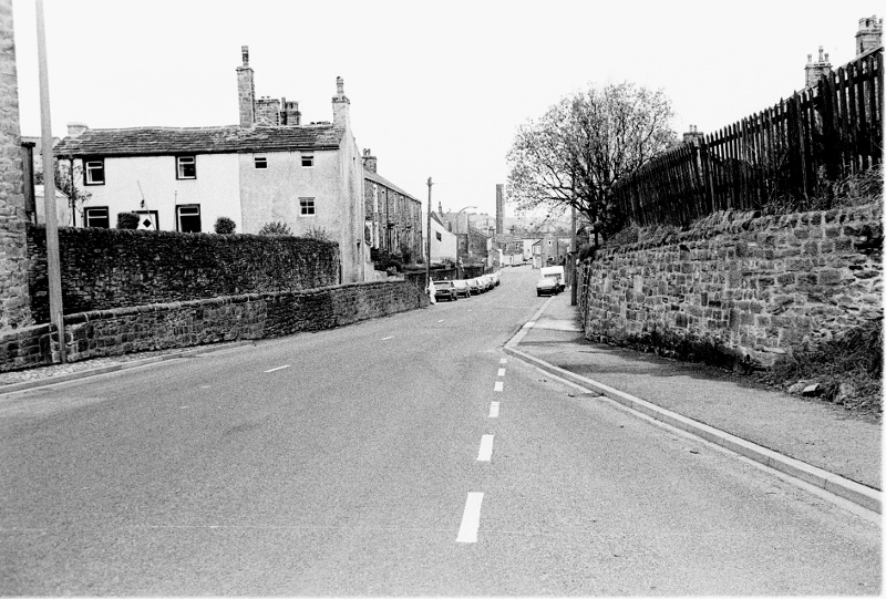
Manchester Road in 1979. Remember me talking about the remains of the old footpath at a raised level? Here you see it and on this side of the road another remnant of the old Barnoldswick Lane. Over the years these bits of evidence are tidied up and we lose the glimpse into the past they afford us.... Many need adjusting but if there is no pressing need we should try to retain these bits of forgotten Barlick.
Re: FORGOTTEN CORNERS
Posted: 31 May 2018, 03:47
by Stanley
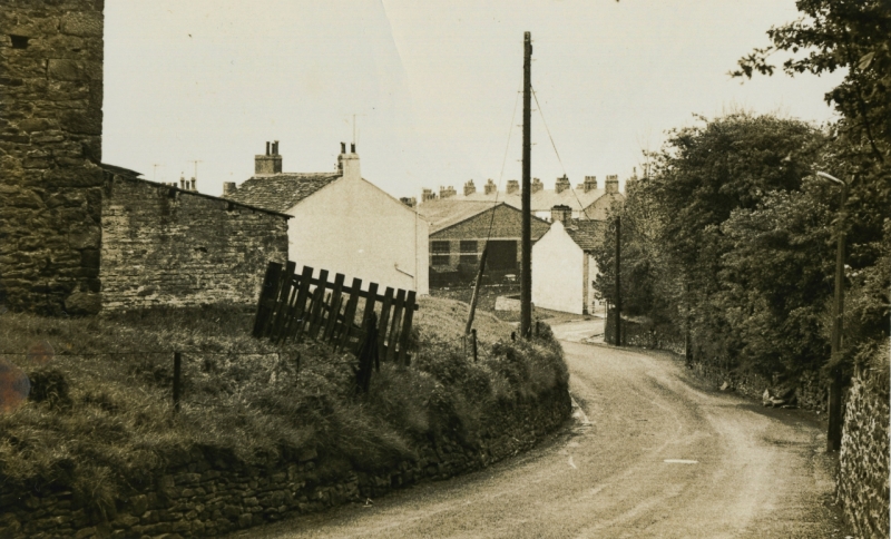
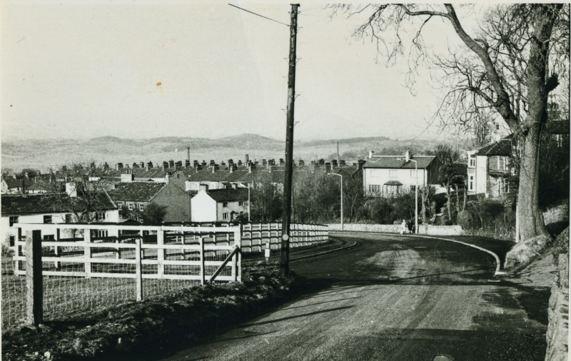
Here are two pics posted by Kev. I love before and after pics! The top one shows the scene in about 1970 when the barn and pig sty were still there in the croft at Hey Farm. Wild's garage there still operating as a haulage firm. The second is after 2002, the garage has gone, the new houses built and the improvements to the road have been done. Lots to look at here. I had to take the hedge out above the stop end and put a new fence in as it wasn't under the contract. I borrowed the contractors tracked shovel one weekend to do the landscaping and reseeding.
Re: FORGOTTEN CORNERS
Posted: 31 May 2018, 06:26
by Big Kev
A bit of useless information to go with this, the civil engineer who worked this project is now in the Isle of Man redesigning Douglas sea front. He's been there a couple of years now as the Manx government can't make their minds up on what they want

Re: FORGOTTEN CORNERS
Posted: 01 Jun 2018, 03:50
by Stanley
Lovely..... Here's another piece of useless information on the same subject. The demolition stone from the Hey Farm barn was carted to Stoneybank at Earby and used to ease a sharp bend on the way up the hill.
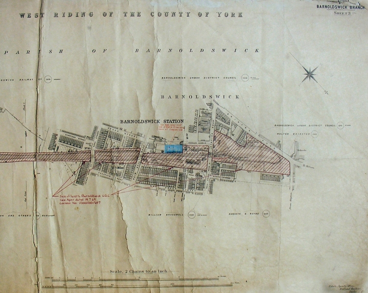
Here's a 1914 map which will repay close study.
Re: FORGOTTEN CORNERS
Posted: 02 Jun 2018, 05:07
by Stanley
Today's forgotten corner doesn't need a picture, all you have to do is step out of your front door and use your eyes! There are very few places in the town where you can't see hills, green fields and open countryside. So many people live in environments where this isn't possible and I'm afraid it wouldn't do for me. Having been forced to be a Bible Scholar by my time at Wycliffe Sunday School in Stockport where teaching was by Bible and parable I always remember psalm 121; "I will lift up mine eyes unto the hills, from whence cometh my help". Whenever I have been in country where it was not green and there were no hills I was never completely at home.
So lift up your eyes when you go out today and see what you can see, it will do you good!
Re: FORGOTTEN CORNERS
Posted: 03 Jun 2018, 03:28
by Stanley
Gully grates are a forgotten corner these days. Amazing when we had the thunder shower how many of them were not taking the water. The contractors they use today must be paid on how many grates they tick off so they don't really bottom them. A large percentage are partially or fully blocked.
Re: FORGOTTEN CORNERS
Posted: 03 Jun 2018, 06:57
by Big Kev
Stanley wrote: ↑03 Jun 2018, 03:28
Gully grates are a forgotten corner these days. Amazing when we had the thunder shower how many of them were not taking the water. The contractors they use today must be paid on how many grates they tick off so they don't really bottom them. A large percentage are partially or fully blocked.
I believe gulley maintenance is a reactive process nowadays, The LCC website has a form available to report them.
Re: FORGOTTEN CORNERS
Posted: 04 Jun 2018, 04:02
by Stanley
Ask David Whipp! He reported lots of them and many were not cured, they were never bottomed by the contractors.
Re: FORGOTTEN CORNERS
Posted: 05 Jun 2018, 05:27
by Stanley
Occasionally my memory lets me down and if I haven't made an entry in the index things get lost. This happened to me this morning, I remembered a corner that is so forgotten even I have lost it. I've had a furtle in the index but so far have found no clue.
So what is this mystery? I once came cross a report made in the 1890s when Barlick Council set on a consultant to look at expanding water supplies in Barlick as demand was rising rapidly and they could see a point where the new waterworks at Whitemoor wouldn't be able to cope. In the end this led to the Elslack reservoir but on the way it was proposed that the run off from Weets via Gillians and Calf Hall becks should be impounded in a large reservoir behind Bancroft Shed.
The only good thing about this is that it has triggered me into a couple of articles on the subject......
Re: FORGOTTEN CORNERS
Posted: 05 Jun 2018, 08:04
by Tizer
Big Kev wrote: ↑03 Jun 2018, 06:57
Stanley wrote: ↑03 Jun 2018, 03:28
Gully grates are a forgotten corner these days. Amazing when we had the thunder shower how many of them were not taking the water. The contractors they use today must be paid on how many grates they tick off so they don't really bottom them. A large percentage are partially or fully blocked.
I believe gulley maintenance is a reactive process nowadays, The LCC website has a form available to report them.
That's all too common now. BT won't even respond to reports of tree branches leaning on telephone cables, it will only come out if the cable breaks or connection is lost.
Re: FORGOTTEN CORNERS
Posted: 06 Jun 2018, 02:44
by Stanley
It's the modern way Tiz, done ostensibly in the name of efficiency but actually down to the bean-counters who look at the cost of everything but not the value.
Many years ago I was sat with Tom Clark in his office at Salterforth talking to him about Silentnight, at that time the biggest bedding makers in the world. He told me that what with regulations and the accountants he was no longer the supreme master of his company. As an example he used his brand new office. There was a bank of switches at the rear of his desk and he said he hadn't the faintest idea of what they were for. He never asked for them, they were just installed by the designers. He told me that in the old days he could walk round the factory and reward someone for outstanding work or sack them for misdemeanours on the spot. Now he had to go through a 'process' and he didn't like it but the company was running him.
He agreed that there were arguments for and against the modern way but on the whole he was a happier man in earlier days when he was growing the company. He was a hard man but not a bad employer. That's a forgotten corner now.....
Re: FORGOTTEN CORNERS
Posted: 06 Jun 2018, 11:32
by PanBiker
Stanley wrote: ↑06 Jun 2018, 02:44
He was a hard man but not a bad employer. That's a forgotten corner now.....
There are quite a number of individuals and Barlick families that would disagree with that Stanley.
Re: FORGOTTEN CORNERS
Posted: 07 Jun 2018, 03:26
by Stanley
And many who would agree as well Ian. What can't be argued against is the fact that he started a business in his back yard in Skipton that eventually gave employment to many thousands of people and still does! None of the old manufacturers were philanthropists and at times behaved harshly but it was they who built Barlick and most importantly put their money back into the town. We have to keep perspective about that particular forgotten corner!
Re: FORGOTTEN CORNERS
Posted: 09 Jun 2018, 05:45
by Stanley
Have you ever wondered why so many of the later mills were built alongside the canal? Many think it was because of ease of transport and that is a factor but not as important as the fact that the canal is a wonderful source of water for the condensers on the engines which made them economical to run. The mills paid the canal company on the basis of the horsepower they were generating and had to send a report in weekly. Being sharp men they indicated the engines on Saturday when weavers were cleaning looms and power demand was at its lowest. A temporary engineer at Moss slipped up and indicated on Monday morning when the engine was running flat out. There were some awkward questions from the canal company about the sudden increase!
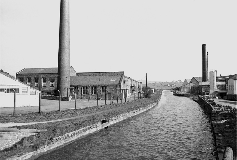
Barnsey and Moss sheds using water from the canal. Long Ing behind us was using the same resource. Notice I say the later mills. The early ones used the urban water resources of the becks and had their own condenser ponds or dams. When all these were used up the canal was the answer to the problem.
Re: FORGOTTEN CORNERS
Posted: 10 Jun 2018, 05:19
by Stanley
The canal has been with us for 200 years and as it's transport role diminished with the rise of rail and road transport it has gradually become a forgotten corner apart from the interest in the mills for condenser water. What we forget is that when it was originally cut it completely altered the drainage pattern of the area. The Canal Company was eager to gather in any water sources in the area, that was why it was diverted through Barlick in the first place. Our stretch is the summit level and any canal depends on having a good inflow of water to make up for water loss at each end due to locking boats through. As traffic decreased, this water was in surplus and anyone who has walked the canal will know that there are major by-washes to control the level, principally at County Brook and another at Greenberfield. We still use the canal to get rid of surplus water in wet seasons, thst's where the troublesome water from the Coates area goes via the new and improved culverts. Remember we are on the watershed, the County Brook Water goes into the Aire Valley basin via Earby and the Greenberfield water into the Ribble basin via Stocks Beck. Properly used and controlled it is our friend. I hope the new masters of the canal have this firmly in mind.
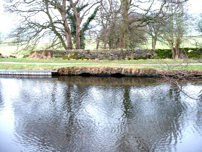
The by-wash at County Brook sending water down to Kelbrook Bottoms and Earby.
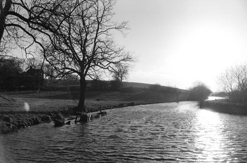
The by-wash at Greenberfield is in the opposite bank to where the old ice boat was sunk.
Re: FORGOTTEN CORNERS
Posted: 11 Jun 2018, 05:22
by Stanley
The generally accepted view of the effects of the last Ice Age on Craven is that it planed everything off at stocking tops but the drumlins out towards the Martons suggest that by the time the ice reached there it was melting and depositing its load of overburden picked up on its movement South.
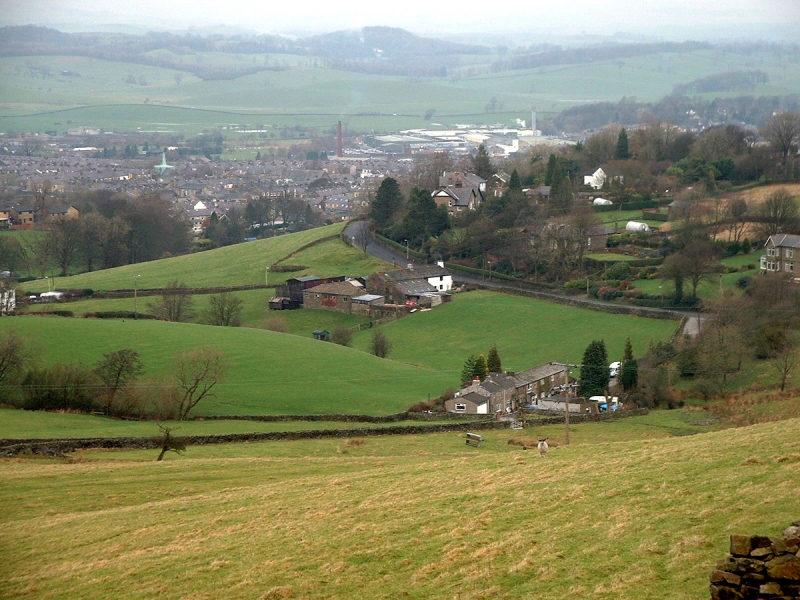
The rounded hills in the background are drumlins.
When John Clayton and I were wandering about on the moor out towards Blacko we found features on the ground that were overlaid by later Stone Age features. Our conclusion was that the older, pre-ice age features, had not been planed off by the glaciers. All the evidence suggested that rather like a flow of water, the ice had divided and passed to each side of the high ground on the moor behind Blacko. It seemed to be the only hypothesis that fitted what we could see on the ground.
If we are right, these features are by far the oldest evidence of human activity in the area, you can throw almost any date at them pre 20,000BC. So when you hear about towns dating back a thousand years to Domesday, be sure that we have a far older history than that!
Re: FORGOTTEN CORNERS
Posted: 12 Jun 2018, 03:40
by Stanley
I've always been fascinated by 'glacial erratics', the isolated large stones that you come across occasionally that are not native to the district. Our ancestors recognised that they were different and sometimes used them as boundary markers. John found a large one near the end of Coal Pit Lane at the Blacko end and we thing that it was used as a marker on the shire boundary. (
LINK)
Re: FORGOTTEN CORNERS
Posted: 13 Jun 2018, 03:49
by Stanley
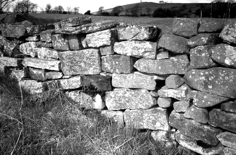
Here's a short piece of wall near the bend in the Blacko Road where Slipper Hill dives into the valley. Blacko tower in the background. So what's so interesting about this heap of stones? It isn't even a good wall!
Stones talk to you if you give them a chance. This came to my notice when John Clayton and I were furtling about on the hillside with the site of Malkin Tower (Home of Mother Demdyke in the Witches of Pendle saga) in mind. I noticed the odd shape of some of the stones in the wall and on closer inspection they turned out to be demolition stone from an old building. Good stones don't just vanish, they get re-used but the question was where had they come from?
The nearest building to the wall is Hollin Hall which while it is evidently an 18th century build has a name that suggests that Holly used as a browse feed in winter was important there, a practice which was much older. In addition, the road at this point has a series of bends in it which suggest that when it was established in pre-medieval times there was a property boundary there that forced the deviation. Add to these clues the fact that stone was never moved further than was absolutely necessary and it seemed a good bet that the demolition stone had come from a much older building on the same site. You can also chuck in another tentative conclusion, that as the building contained dressed stone and was built at a time when stone buildings were usually monastic or royal (Masons didn't become common in the wider community until after the Dissolution of the Monasteries in the mid 16th century) it was of some importance.
Was this Malkin Tower? we decided not as there were other clues in that search but this obscure little heap of stones on the side of the road had a story to tell so never ignore stones if they start talking to you.....
Re: FORGOTTEN CORNERS
Posted: 14 Jun 2018, 04:15
by Stanley
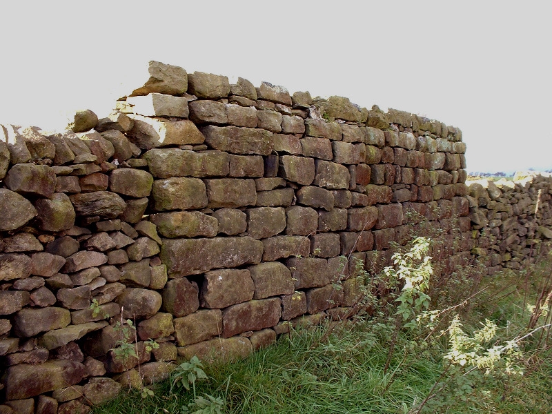
On the same trip John and I had a good look at Malkin Tower Farm. Local folk memory holds that Malkin Tower was somewhere near the big gulley that runs up the hillside, Hayn Slack. We came across this piece of wall behind Malkin Tower Farm but whilst we didn't know the reason for it being so different, dismissed it as part of an original building that could have been the Tower. But it's a bit of a mystery!
John has done a lot of research since but I am not sure what his conclusions are. All I can remember is that there was evidence of early stone buildings, some with monastic connections, all over Blacko hillside. Best thing to do is get hold of a copy of John's 2007 book 'The Lancashire Witch Conspiracy' and look at chapter 20......
Re: FORGOTTEN CORNERS
Posted: 14 Jun 2018, 06:51
by plaques
Where did Johnathan Stansfield ( 1890 ) get his stone from to build Blacko Tower?
Re: FORGOTTEN CORNERS
Posted: 15 Jun 2018, 02:52
by Stanley
There's a quarry just to the South of the tower. There were unfinished stone gate posts in there last time I was there so it was a source of good sized stones.
Re: FORGOTTEN CORNERS
Posted: 16 Jun 2018, 05:48
by Stanley
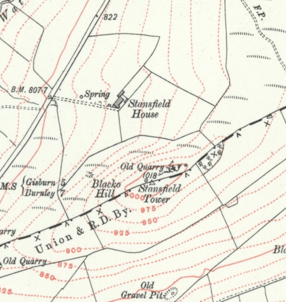
Here's a map of the tower showing the quarry.
Re: FORGOTTEN CORNERS
Posted: 17 Jun 2018, 05:24
by Stanley
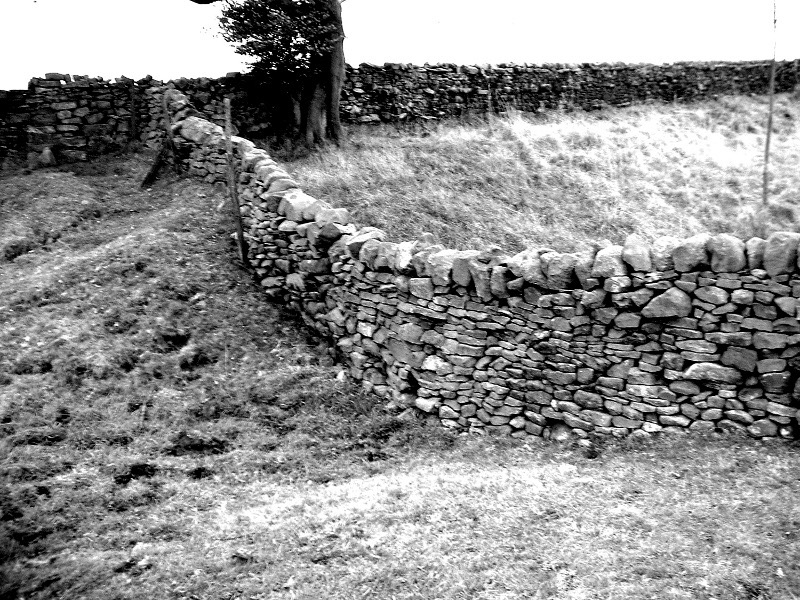
While we are up near the Tower let's not forget the Black Dyke. This big feature, and remember that when it was new it would be much deeper and more significant, runs northwards across the moor towards Weets and John assures me it goes forward from there towards Gisburn but I have never walked that stretch. My guess is that it was a significant tribal boundary and is well over 2,000 years old. It finishes just to the East of Blacko Tower. Even today with modern machinery it would be a massive earth-moving job. I call it Black Dyke because that is the name given to it on the Whitemoor Map of 1580 which was made to support a Chancery dispute between the Manor of Foulridge and that of Barnoldswick. It is cited as the western boundary of the Manor of Barnoldswick and agrees with the perambulation by Henry de Lacy of 1147 made when he was gifting the manor to Fountains Abbey as thanks for his recovery from a serious illness.
Re: FORGOTTEN CORNERS
Posted: 18 Jun 2018, 04:10
by Stanley
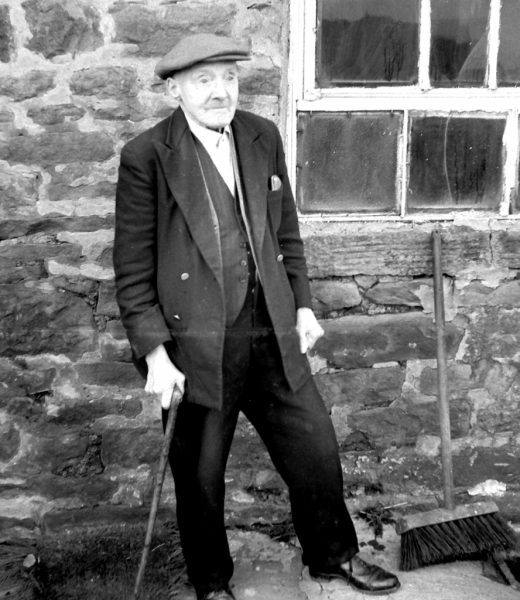
Half way up the hill on Gisburn Old Track was Peel House which I suspect was originally a squatter's house. The Carters lived there and also Sally Carter's father Jim 'Boss' Smith. Here he is in 1957 and was somewhere near 100 years old at the time. He is a forgotten corner in his own right. He was alive when Barlick was just moving into the steam age.... He was as tough as an old boot!
Re: FORGOTTEN CORNERS
Posted: 19 Jun 2018, 03:24
by Stanley
The biggest forgotten corner of all is the knowledge and experience lost when someone as old as Jim Boss dies. That was what drove me to do the LTP. A classic example of this is the old workers who often volunteer as guides in heritage attractions because they worked there in their younger days. They are a wasting asset and that's why it's important to record forgotten corners in topics like this or the LTP. It isn't private, if any of you have a forgotten corner you would like to see recorded, post it here. We can't have too many!
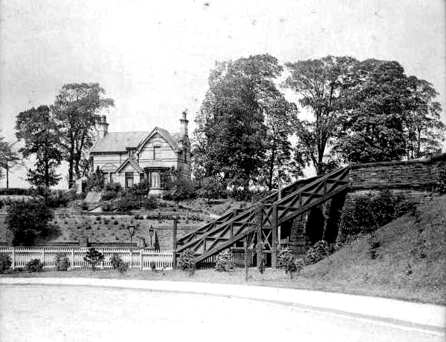
Here's a case in point. Gisburn Railway Station in 1903. Looking more like a gentleman's country residence than a railway station!