I reme mber reading one of your posts about it so with the link posted above, I had a scan around all the area I thought you hinted at and a couple of weeks ago had a wander onto one of my favourite little tops at wheathead. Give me a hint if I'm close and I'll do a bit more wandering in the summer. The lidar link didn,t show anything up of significance that I could detect but very enjoyable anyway
Best of luck with your current search, it's totally fascinating.
EARLY SETTLEMENT IN WEST CRAVEN
-
Stanley

- Global Moderator

- Posts: 90301
- Joined: 23 Jan 2012, 12:01
- Location: Barnoldswick. Nearer to Heaven than Gloria.
Re: EARLY SETTLEMENT IN WEST CRAVEN
Too far down in the valley. Have a look at OS SD8345. It's big, look at surrounding grid squares as well.
Stanley Challenger Graham
Stanley's View
scg1936 at talktalk.net
"Beware of certitude" (Jimmy Reid)
The floggings will continue until morale improves!
Stanley's View
scg1936 at talktalk.net
"Beware of certitude" (Jimmy Reid)
The floggings will continue until morale improves!
-
John C Layton
- Newbie
- Posts: 54
- Joined: 09 Dec 2015, 15:57
Re: EARLY SETTLEMENT IN WEST CRAVEN
Have been sidetracked lately by archaeologist types in Bacup - a fascinating landscape over there which, as it turns out, appears to have been directly linked to our area. Early stages yet but it could well be that the Broadclough area was densely settled in prehistory - it has many defensive features controlling the central Pennine northern route that ran along a line of hillforts from Sharneyford, through Nerslon and Colne and up to Elslack Moor. I have a theory that Bacup was located on the western perimeter of a central Pennine kingdom with Connonley/Gargrave/Hellifield at the eastern limit - this may have formed a boundary with the Brigantes proper and would have formed a buffer state between the Brigantes and the Setantii tribe of the west coast areas.
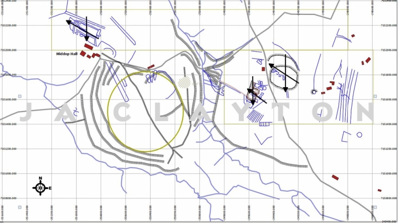
Jpmurray - Stanley is right about the Middop site. It is not a hillfort but a delineated/enclosed site. It may be that there never was actual settlement within the site itself - there is certainly a deep linear feature running through it and these are commonly found on hill sites where a defensive area is separated from a settlement area - however, this feature could also be a hollow-way that served Medieval settlement here. I have attached a bare-feature sketch from ASCII LiDAR showing the enclosure with settlement areas to the north and east of this (cross-arrowed). The enclosure would benefit from geophys survey to determine whether it contained houses - further, the external settlement areas need to be assessed to date them. It is reasonably clear that the Middop area was settled at an early date and this was the case throughout the Medieval period.
Loking back over this thread I see that 6fingers provided a link to the Enfield History Society website. I haven't come across this before - it's a brilliant resource for bringing general LiDAR to the public - easy to use and to navigate. Now . . . as always there is a caveat - you get what you pay for! The LiDAR data on the site is in the form of .jpg and this is very limited in detail scope in relation to the images provided by ASCII data files. This means that if nothing is apparent within the area you are searching (on the link site) it can well be that it is just not showing up. That said - it is far better than nothing and it would be great if we saw a flood of new sites emerging from the public.
-
Stanley
- Global Moderator
- Posts: 90301
- Joined: 23 Jan 2012, 12:01
- Location: Barnoldswick. Nearer to Heaven than Gloria.
Re: EARLY SETTLEMENT IN WEST CRAVEN
My approach to Middop has always been to ask myself what the imperative was to put that amount of investment into it. I can buy that in an early stage and on a smaller scale it could have been defensive but when you think of how gig the garrison would have to be to defend something that size you begin to look sideways and I get the feeling it was trade between the Ribble Valley route to the coast and Ireland beyond and the hinterland to the East, particularly bearing in mind the Aire Gap and Kildwick, the route out to the sea and the Baltic states and the availability of gold in Ireland (Lead locally as well). There could have been an element of display too but simple brigandage and looting in the Ribble Valley wouldn't be enough. We also have to bear in mind the effects of climate, at some periods it was a lot more clement on that hillside.
Whichever way you look at it, it is a fascinating feature and without doubt had transport linkages both East and West.
Whichever way you look at it, it is a fascinating feature and without doubt had transport linkages both East and West.
Stanley Challenger Graham
Stanley's View
scg1936 at talktalk.net
"Beware of certitude" (Jimmy Reid)
The floggings will continue until morale improves!
Stanley's View
scg1936 at talktalk.net
"Beware of certitude" (Jimmy Reid)
The floggings will continue until morale improves!
-
jpmurray681
- Newbie
- Posts: 31
- Joined: 06 Nov 2014, 15:05
Re: EARLY SETTLEMENT IN WEST CRAVEN
I had noticed that the lidar images produced on the link provided by 6fingersskipton didn't provide as much detail as one might want but still provoked interest.I'm only a casual searcher of all things old and had managed to speculate an approximate area for the site and although the images showed some features, I would not have picked it out as significant.
One thing which did stand out was a very square feature in the valley which runs due north from the Wheathead hilltops. A footpath goes right by it. It may of course be a modern structure and i'll have a look next time i'm up there
One thing which did stand out was a very square feature in the valley which runs due north from the Wheathead hilltops. A footpath goes right by it. It may of course be a modern structure and i'll have a look next time i'm up there
-
Stanley
- Global Moderator
- Posts: 90301
- Joined: 23 Jan 2012, 12:01
- Location: Barnoldswick. Nearer to Heaven than Gloria.
Re: EARLY SETTLEMENT IN WEST CRAVEN
Just shows that while LIDAR is useful, nothing beats getting on the ground.
Stanley Challenger Graham
Stanley's View
scg1936 at talktalk.net
"Beware of certitude" (Jimmy Reid)
The floggings will continue until morale improves!
Stanley's View
scg1936 at talktalk.net
"Beware of certitude" (Jimmy Reid)
The floggings will continue until morale improves!
-
John C Layton
- Newbie
- Posts: 54
- Joined: 09 Dec 2015, 15:57
Re: EARLY SETTLEMENT IN WEST CRAVEN
JP - if you can post an image of the LiDAR feature (or a coordinate for the site) I'll run it through GIS to see what we might have. We haven't covered this area in any detail in the BCNWC Project survey so it would be very useful for someone like yourself to look over it.
-
jpmurray681
- Newbie
- Posts: 31
- Joined: 06 Nov 2014, 15:05
Re: EARLY SETTLEMENT IN WEST CRAVEN
John, the feature which got my attention is at 3833434. Hope it proves of some interest.
-
John C Layton
- Newbie
- Posts: 54
- Joined: 09 Dec 2015, 15:57
Re: EARLY SETTLEMENT IN WEST CRAVEN
JP - have attached image of a feature at:
X (Easting) 383965 Y (Northing) 442374
SD 83965 42374
Lat 53.87731 Long -2.24539
West of Height House Farm on Wheathead Height which I think is the one you have noted?
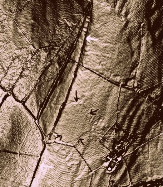
Well spotted - I can see why you are interested in the sub-square feature as it appears to be a ditched enclosure on the 1m DSM LiDAR. The ASCII image above shows the feature more clearly and it can be seen that the ditches are for drainage purposes (or are natural linear water slippage).
The western edge of the feature butts against a trackway (arrowed white) - this was formerly an important route running from the Wattling Ford on Pendle Water (wattling = OE 'foreigner' which suggests the ford connected two adjoining tribal areas or kingdoms) up Wheathead and over to the Middop settlement site. This connected the Howgill Roman route with Ribchester via Sabden Fold.
Keep the features coming!
X (Easting) 383965 Y (Northing) 442374
SD 83965 42374
Lat 53.87731 Long -2.24539
West of Height House Farm on Wheathead Height which I think is the one you have noted?
Well spotted - I can see why you are interested in the sub-square feature as it appears to be a ditched enclosure on the 1m DSM LiDAR. The ASCII image above shows the feature more clearly and it can be seen that the ditches are for drainage purposes (or are natural linear water slippage).
The western edge of the feature butts against a trackway (arrowed white) - this was formerly an important route running from the Wattling Ford on Pendle Water (wattling = OE 'foreigner' which suggests the ford connected two adjoining tribal areas or kingdoms) up Wheathead and over to the Middop settlement site. This connected the Howgill Roman route with Ribchester via Sabden Fold.
Keep the features coming!
-
jpmurray681
- Newbie
- Posts: 31
- Joined: 06 Nov 2014, 15:05
Re: EARLY SETTLEMENT IN WEST CRAVEN
Hi John, I need to apologize as I seem to have managed to stick an extra number on the front of my grid ref. It should read 834 435 and is very slightly south west of Craven Laithe farm. I think it may be little streams on two sides and then it's squared off on the other sides. As I said it seems to be bordered by a track running towards Middop.
-
Stanley
- Global Moderator
- Posts: 90301
- Joined: 23 Jan 2012, 12:01
- Location: Barnoldswick. Nearer to Heaven than Gloria.
Re: EARLY SETTLEMENT IN WEST CRAVEN
'Seek and ye shall find'.......
Stanley Challenger Graham
Stanley's View
scg1936 at talktalk.net
"Beware of certitude" (Jimmy Reid)
The floggings will continue until morale improves!
Stanley's View
scg1936 at talktalk.net
"Beware of certitude" (Jimmy Reid)
The floggings will continue until morale improves!
-
John C Layton
- Newbie
- Posts: 54
- Joined: 09 Dec 2015, 15:57
Re: EARLY SETTLEMENT IN WEST CRAVEN
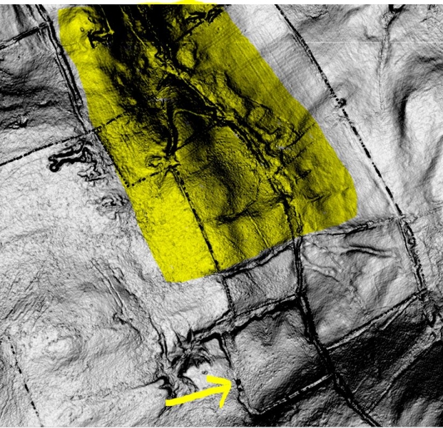
PJ's location at SD834435 (south west of Craven Laithe Farm, Middop). The LiDAR image shows the square feature (arrowed) to be formed by two drainage ditches, a trackway and the Collaver Syke stream.
However, a short distance northward along Collaver Syke is Bale Hill. About ten years ago, while researching the lead mines at Rimington, I wrote:
Looking at the LiDAR image above it is fair to say that this idea of mining at Bale Hill still appears to have legs - the area in question is highlighted in the image and this shows evidence of rectilinear features on the eastern stream bank, mounds and general ground disturbance.On Rimington Moor, about one mile southeast of the Skelhorn lead and silver mine, is a hill called Bale Hill - this is next to a stream known as Collaver Syke. Bale Hill appears to have been worked for some commercial purpose due to the roughness and pock-marking of the ground. The word Bale was used in the Middle-ages to describe the refining areas on the surface of mines - a place where the mined materials would be sorted or, in the case of metal-bearing ores, washed, crushed and even smelted. I have a theory that the word derives from the OE 'Bel', meaning 'head', which would equate with our modern 'pit-head'.
To further the argument it is interesting that the name Collaver Syke translates from the OE as colafirran where cola = coal and (a-)firran is to remove and take away. This points, then, to coal mining on the site - it is interesting to note that a trackway ran directly from Bale Hill westward through the Craven Laithe farm site and directly to Coal Pit Lane below Weets Hill.
-
jpmurray681
- Newbie
- Posts: 31
- Joined: 06 Nov 2014, 15:05
Re: EARLY SETTLEMENT IN WEST CRAVEN
Fascinating facts and theories and now that little area is a bit remote and unused. Just on the top of the nearby lowest of the two Wheathead tops is evidence of much disturbance which I took to be quarrying activity but may also be mining.
-
John C Layton
- Newbie
- Posts: 54
- Joined: 09 Dec 2015, 15:57
Re: EARLY SETTLEMENT IN WEST CRAVEN
I think the Wheathead Heights disturbance is stone extraction but I was told years ago that there had been an alum mine in that area. Not sure if this is correct or where the information came from.
-
John C Layton
- Newbie
- Posts: 54
- Joined: 09 Dec 2015, 15:57
Re: EARLY SETTLEMENT IN WEST CRAVEN
STRATSURGHAM - a lost village at Middop?
I have been meaning to get over to Howgill (a hamlet on the road from the A683 to Rimington) for some time - I have driven through the place many times but never walked it – until today. I have been busy with lost village sites along the route of the Ribchester to Ilkley Roman road, from Elslack to Downham, and it is clear that there was a great deal of settlement within the Middop/Rimington/Twiston/Downham/ Gisburn area. The Bronze Age and Iron Age periods are very well represented but what has taken my eye is the number of settlements alongside the Roman road.
It is known that, during the 2nd century AD in particular, native British tradesmen and merchants took advantage of the passing trade afforded by Roman roads by setting up roadside stalls, inns, smithies etc. These often graduated from a single wooden hut into a village or hamlet – some of which survive to this day and some of which have long been lost. It is these latter sites that can be found through LiDAR.
Howgill is a surviving example of a roadside hamlet – whether it can be dated to the Roman period is, at present, unknown. What is clear is that the site sits on the Roman road at the juncture of two streams – the site of a Roman bridge or ford and, therefore, an ideal commercial Romano-British site. A cluster of serious earthworks can be seen in the fields and crofts on the western edge of the hamlet and the site is directly linked to the Bronze Age/Iron Age settlement at nearby Middop Hall.
While researching Howgill I came across Whitaker’s reference (History Of Craven) to a village in the vicinity that I had never previously heard of:
Craven (Domesday) consisted of the following townships: Remington, Crooke, Midhope and Stratsurgham (now Strasergh) etc. All these names are yet intelligible; and all the places which they denominated yet remain. Stratesurgum, now contracted to Strasergh, carries something Roman in its sound. That the Roman ‘Street’ from Ribchester to Ilkley passed through this parish has already been proved; and that a Station hereabouts, at the distance of 17 or 18 Italian miles from Ribchester, might antecedently to all evidence be expected, is obvious.
Stratesurgum, then, was a township/village in the Middop area and the etymology points strongly to the place being named because it was on (or near) the Roman road. In fact the Latin translation of Stratesurgum is ‘Steep Street.’ This becomes interesting when the geographical layout of the Ribchester-Ilkley road is studied. On the line from Ribchester to Rimington the road is very level and only diverts from this for a short distance when crossing the extant ford at Torrid Bank. At Howgill, however, the road descends sharply into the hamlet and then climbs very steeply for half a mile before meeting with the A683.
In the fields alongside the climbing Roman road the LiDAR shows clear linear hollows and platforms which could be taken for a drainage system. However, having now seen the landscape layout I am fairly sure that these features represent hollow ways and occupation platforms - we have here a lost village. Further, the fact that the site lies alongside the steepest section of Roman road it seems fair to suggest that this is the location of the lost Stratsurgham (unless someone can point me in the direction of an existing place of that name).
So . . . Stratsurgham would have been a small settlement alongside the busy Roman road, exactly at a marching distance of 18 miles from Ribchester (as noted by Whitaker) and half-way from there to the Elslack fort. Within the Roman Iter system there was a station or settlement named ‘Collunio amid the Pennines’ which has not yet been sited with any degree of certainty (Colne is a possibility). This would have been a place sited at a strategic distance between known forts and would have been a settlement with a military facility. Interestingly enough certain images of the proposed Stratsurgham site strongly suggest such a stone-enclosed feature very close to the settlement (fieldwork to be done here).
Stratsurgham?
Roman Road through possible site of Stratsurgham
-
Stanley
- Global Moderator
- Posts: 90301
- Joined: 23 Jan 2012, 12:01
- Location: Barnoldswick. Nearer to Heaven than Gloria.
Re: EARLY SETTLEMENT IN WEST CRAVEN
Fascinating John.... EPNS first reference to 'Hollegile', 1200, is in the Sawley Abbey papers. Whitaker would be pleased.....
What you are doing is a perfect illustration of the fact that the more we look, the more there is to be found. One of the things that first struck me about the Middop earthworks was that such a massive construction had to be rooted in something like more population than we suspected in the area, trade or raiding in the Ribble Valley. It makes sense if you are finding more settlement in the immediate area. Good stuff and thanks for posting it.
What you are doing is a perfect illustration of the fact that the more we look, the more there is to be found. One of the things that first struck me about the Middop earthworks was that such a massive construction had to be rooted in something like more population than we suspected in the area, trade or raiding in the Ribble Valley. It makes sense if you are finding more settlement in the immediate area. Good stuff and thanks for posting it.
Stanley Challenger Graham
Stanley's View
scg1936 at talktalk.net
"Beware of certitude" (Jimmy Reid)
The floggings will continue until morale improves!
Stanley's View
scg1936 at talktalk.net
"Beware of certitude" (Jimmy Reid)
The floggings will continue until morale improves!
-
John C Layton
- Newbie
- Posts: 54
- Joined: 09 Dec 2015, 15:57
Re: EARLY SETTLEMENT IN WEST CRAVEN
Thanks for that Stanley - Hollegille (hol = hollow) fits the landscape exactly where a deep running gulley passes through a well defined depression at Howgill.
Just noticed that I have made a mistake in that Stratsurgham should be Stratsurgum. This makes a big difference to the site context in that 'ham' would describe the place as being of the Saxon period - in fact the suffix 'um' is the Latin singular being applied to the passive context of 'Surgo' - Stratsurgum is a description of the effects of rising ground acting on the Roman road.
I forgot to mention that a tree has toppled on the old Roman road and I found a Neolithic hand axe in its roots. Also, in the adjacent field I spotted a piece of vitrified/partly glazed sandstone that has been in a pottery kiln - more evidence of settlement.
You are right about the Middop site Stanley.Having spent a couple of weeks mapping the site it is clear that this was important. There are three connected, but distinct, landscape features in the form of defended hill settlements (Middop being the middle of the three). The combined Bronze Age and Iron Age settlement covers a large area from Craven Laithe down to Howgill. The Craven Laithe enclosure appears to have a Bronze Age ring cairn burial similar to that on Hare Hill above Elslack.
-
Stanley
- Global Moderator
- Posts: 90301
- Joined: 23 Jan 2012, 12:01
- Location: Barnoldswick. Nearer to Heaven than Gloria.
Re: EARLY SETTLEMENT IN WEST CRAVEN
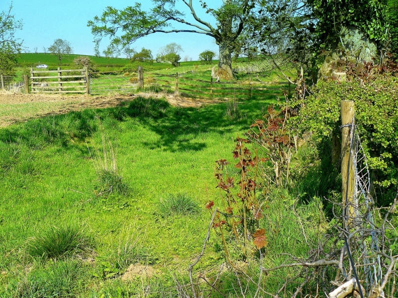
When I looked at it I thought I could detect a field system above the main earthworks and some sort of an enclosure in the top (SW) corner that might have been a burial site. Apart from that and the ditches, the main feature was the exit towards Middop Hall and the Ribble valley which was arranged so that if necessary defenders had a height advantage over anyone coming into the site up the hill. I could see them throwing rocks down at them! There were some interesting later field boundaries at that end as well, Stone base, turf wall and a hedge on top. Even then with just a couple of visits it was obvious that there was lots of information in the ground.
As for the casual mention of finding an axe head.... only you John! I did this sketch map at the time....
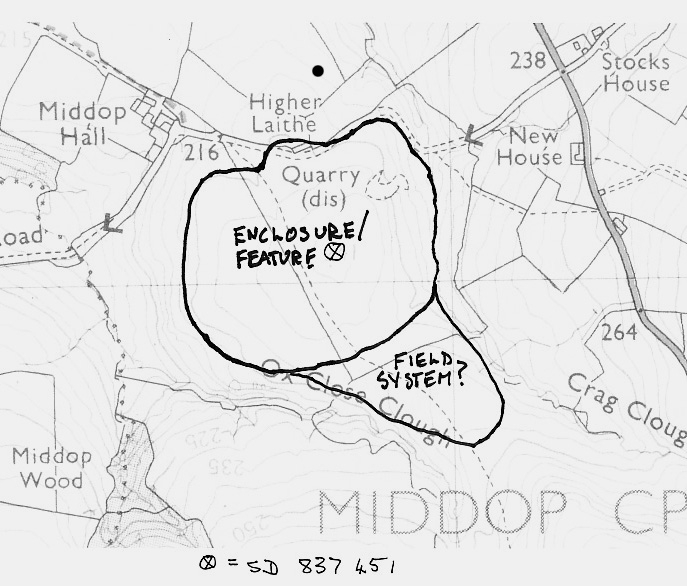
As for the casual mention of finding an axe head.... only you John! I did this sketch map at the time....
Stanley Challenger Graham
Stanley's View
scg1936 at talktalk.net
"Beware of certitude" (Jimmy Reid)
The floggings will continue until morale improves!
Stanley's View
scg1936 at talktalk.net
"Beware of certitude" (Jimmy Reid)
The floggings will continue until morale improves!
-
John C Layton
- Newbie
- Posts: 54
- Joined: 09 Dec 2015, 15:57
Re: EARLY SETTLEMENT IN WEST CRAVEN
Your enclosure feature is accurate Stanley - especially given it was drawn from groundwork and not air information. Interestingly, there is also a very faint trace of a square enclosure within this circle.
The 'field system' to the south of this is modern intake of the moor through a large drainage system. This would appear to have originally served as a buffer (no-man's-land) between the two massive enclosures at Craven Laithe and Middop.
You mention the entrance to the site from up the hill (north to south) - this could turn out to be key to understanding the whole site. The deep hollow-way track running through the enclosure (marked on your plan as a footpath) heads through Middop Hall Farm and straight down to Howgill/Gazegill. This is where two streams meet and were forded/bridged by the Roman road - the Middop enclosure road joined the Roman road at this spot. Further, the two streams form the bounds of the northern extent of the extended Middop hill settlement. It is apparent that major earthworks here were related to the control of the major arterial Bronze Age/Iron Age/Romano-British route here.
On top of this, watermeeting sites were highly venerated, especially in the Iron Age, and it can reasonably be expected to find important ritual earthwork activity at these places. An example is the Blacko Water/Pendle Water Watermeetings at Barrowford where we have found a defended hill settlement, a lost stone circle, a semi-natural amphitheatre, rare Neolithic tools, Roman coins etc. This site is located on the major E-W pre-Roman route from the west coast which carries over Wheathead and drops down into the Middop enclosure as the track mentioned above.
So. . . . next step is permissions and fieldwork - this sleepy hollow hides many secrets.
-
Stanley
- Global Moderator
- Posts: 90301
- Joined: 23 Jan 2012, 12:01
- Location: Barnoldswick. Nearer to Heaven than Gloria.
Re: EARLY SETTLEMENT IN WEST CRAVEN
Thanks for that John and yes I did the sketch on site. That hollow way grabbed me, obviously defensive/ceremonial and also the age of the field walls adjacent. A bloke could spend a lifetime on just that one site! The advantage you are getting now is being able to knit it all together with the surroundings because you have done more field walking and have the backing of the aerial work....
I've always said that at some time in the future they will have ground penetrating technology that will show all sorts of stuff!
I've always said that at some time in the future they will have ground penetrating technology that will show all sorts of stuff!
Stanley Challenger Graham
Stanley's View
scg1936 at talktalk.net
"Beware of certitude" (Jimmy Reid)
The floggings will continue until morale improves!
Stanley's View
scg1936 at talktalk.net
"Beware of certitude" (Jimmy Reid)
The floggings will continue until morale improves!

Re: EARLY SETTLEMENT IN WEST CRAVEN
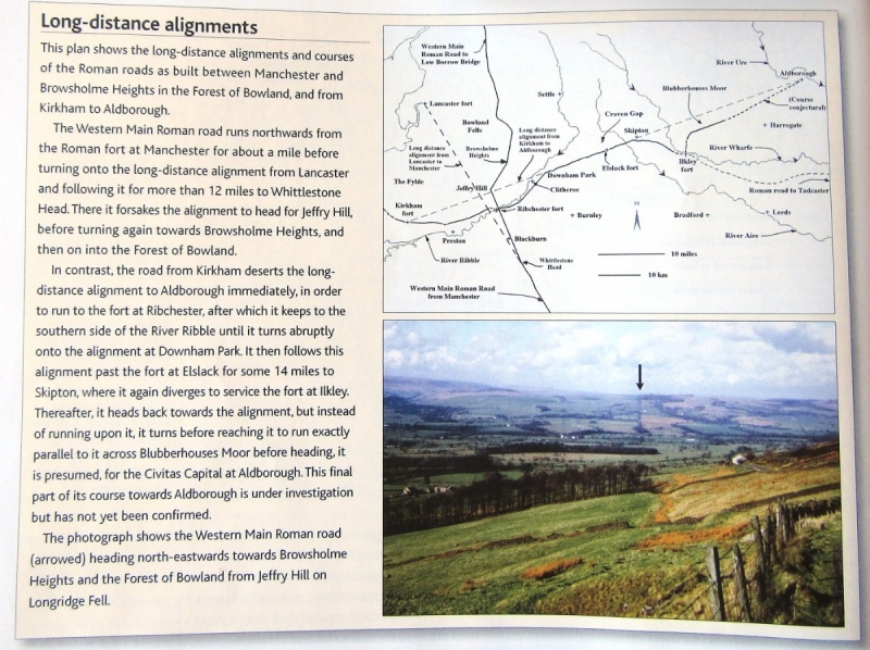
Excuse me butting in here but I thought that those of you interested in this thread would also appreciate the following graphic. It's from an article by John Poulter and Rob Entwistle on the long-distance alignments of Roman roads in England, pages 12-18 of the May 2016 issue of `Current Archaeology' magazine. The article proposes that a number of Roman roads adapted long-distance alignments derived from surveys made in the early years of the Roman conquest.
Nullius in verba: On the word of no one (Motto of the Royal Society)
-
John C Layton
- Newbie
- Posts: 54
- Joined: 09 Dec 2015, 15:57
Re: EARLY SETTLEMENT IN WEST CRAVEN
Nice one Tizer - this is from the Roman Road Research Organisation who use LiDAR to locate lost Roman roads. It is interesting that our stretch of the Kirkham-Ilkley road (from Downham to Skipton) is the only length following the projected alignment.
The essence of the article is that the Romans surveyed long distance alignments at an early stage of their conquest of Britain. Then, as time progressed, they used the information to site their expanding road system. This is all well and good if it weren't for one simple fact - there was a vast network of established roads in Britain long before the Romans arrived. Bronze and Iron Age trade routes ran for long distances, straight across rivers, marshes and moorland - some of these roads were at least as well constructed as the Roman ones and the incomers naturally used these where they fitted in with their defensive system of forts and settlements. In fact, most Roman fort sites are located near to, or within, Iron Age hillforts. It is a pity that the skills of the native British people are not fully recognised by many archaeologists and historians - the general impression we are given is that society began with the Romans.
The essence of the article is that the Romans surveyed long distance alignments at an early stage of their conquest of Britain. Then, as time progressed, they used the information to site their expanding road system. This is all well and good if it weren't for one simple fact - there was a vast network of established roads in Britain long before the Romans arrived. Bronze and Iron Age trade routes ran for long distances, straight across rivers, marshes and moorland - some of these roads were at least as well constructed as the Roman ones and the incomers naturally used these where they fitted in with their defensive system of forts and settlements. In fact, most Roman fort sites are located near to, or within, Iron Age hillforts. It is a pity that the skills of the native British people are not fully recognised by many archaeologists and historians - the general impression we are given is that society began with the Romans.
-
Stanley
- Global Moderator
- Posts: 90301
- Joined: 23 Jan 2012, 12:01
- Location: Barnoldswick. Nearer to Heaven than Gloria.
Re: EARLY SETTLEMENT IN WEST CRAVEN
Well spotted Tiz. I have often noted the dichotomy between the Roman predilection for arrow straight alignments and the diversions from that line, often easily explained by topography but sometimes less obvious. I had never thought about the influence of existing roads.....
Stanley Challenger Graham
Stanley's View
scg1936 at talktalk.net
"Beware of certitude" (Jimmy Reid)
The floggings will continue until morale improves!
Stanley's View
scg1936 at talktalk.net
"Beware of certitude" (Jimmy Reid)
The floggings will continue until morale improves!
-
Stanley
- Global Moderator
- Posts: 90301
- Joined: 23 Jan 2012, 12:01
- Location: Barnoldswick. Nearer to Heaven than Gloria.
Re: EARLY SETTLEMENT IN WEST CRAVEN
See THIS BT report of LIDAR surveying which is revealing hitherto hidden evidence of far more extensive communal farming than was suspected in the early Iron Age.
Stanley Challenger Graham
Stanley's View
scg1936 at talktalk.net
"Beware of certitude" (Jimmy Reid)
The floggings will continue until morale improves!
Stanley's View
scg1936 at talktalk.net
"Beware of certitude" (Jimmy Reid)
The floggings will continue until morale improves!
Re: EARLY SETTLEMENT IN WEST CRAVEN
I've just put a link to an archaeology petition in this other OG thread: LINK
Nullius in verba: On the word of no one (Motto of the Royal Society)