EARLY SETTLEMENT IN WEST CRAVEN
-
PanBiker

- Site Administrator

- Posts: 16447
- Joined: 23 Jan 2012, 13:07
- Location: Barnoldswick - In the West Riding of Yorkshire, always was, always will be.
Re: EARLY SETTLEMENT IN WEST CRAVEN
Havre Park is an old name for the area John, most Barlickers will know where you mean if mentioned.
Ian
-
Stanley

- Global Moderator

- Posts: 90295
- Joined: 23 Jan 2012, 12:01
- Location: Barnoldswick. Nearer to Heaven than Gloria.
Re: EARLY SETTLEMENT IN WEST CRAVEN
Havre is OE for oats, hence haversack. Havre Park is good flood plain soil and almost certainly derived from an old field name. Havre Park the park (area) where oats are grown. The Bolton Priory records mention the purchase of grain from Barlick as well as large timbers.
Stanley Challenger Graham
Stanley's View
scg1936 at talktalk.net
"Beware of certitude" (Jimmy Reid)
The floggings will continue until morale improves!
Stanley's View
scg1936 at talktalk.net
"Beware of certitude" (Jimmy Reid)
The floggings will continue until morale improves!
-
John C Layton
- Newbie
- Posts: 54
- Joined: 09 Dec 2015, 15:57
Re: EARLY SETTLEMENT IN WEST CRAVEN
ROMAN BARLICK
Took adavantage of the strangely fine weather this afternoon and had a tramp around the old town looking for evidence on the ground for the first foundations of Barlick. I must say that the area between Church St and Chapel Street is a credit to the town - well kept, no shops boarded up and clean streets. This area still retains a fascinating link to its early roots with the footprint of a semi-nucleated village at its heart.
However, brilliant as the medieval layout of the town might be I was in search of earlier evidence. Having raised the possibility that a Roman fort stood on the area now occupied by Cobden St to Park Rd and Chapel St to Park Avenue it was a case of seeing if the landscape might support this theory. Having wandered around for an hour I am even more convinced of a Roman presence here - to my mind the evidence on the ground strongly suggests that Barnoldswick was originally a small Roman walled town.
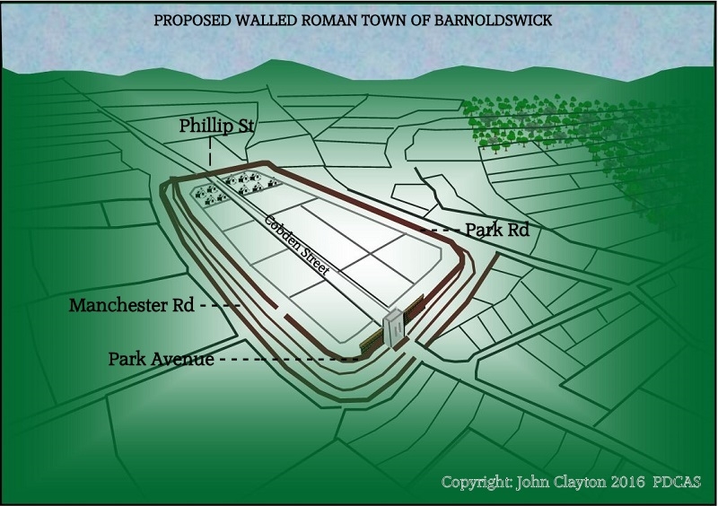
I am currently writing a report on this so won't go into rambling detail - suffice it to say that there is every possbility that Barlickers walking along Philip St, Jepp Hill and Chapel St have been crossing the ditched and terraced ramparts of a Roman enclosure without ever realising it. I wonder if the British Legion Club was originally a Roman Legion Club?
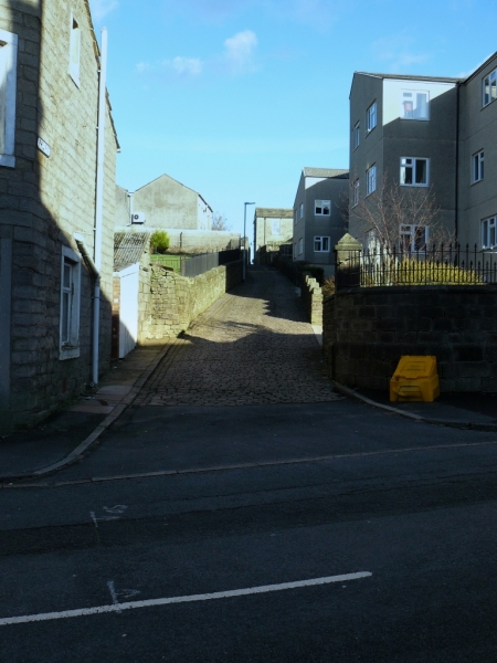
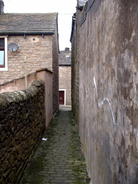
Chapel St and Phillip St looking up from Manchester Road to the ridge top - probable town ditches.
At this stage it appears that the northern town ditch followed the line of Jepp Hill with inner terraced defences following the lines of Phillip St and Chapel St from Manchester Rd up to the ridge running along Cobden Street. The original road would run from the south through Letcliffe and down to the southern gatehouse. Manchester Rd may have been an outer track at the base of the terraced defences or might have been a much later road built along the line of the outer town ditch.
The jumble of houses between Chapel St and Church St stand on the viccus area just outside of the northern ditch - this layout could well have a middle Anglo-Saxon foundation as the Angles rarely occupied earlier Roman towns as they preferred to build their villages on the outside of the abandoned walled areas.
It's a pity that all of the enclosure has been covered by development but it is certain that archaeological evidence will survive in the fields around Letcliffe. Hopefully it would be possible to locate and date the original road down into the proposed town by putting in a couple of small test pits. Further, there would be other forms of landscape evidence such as ditches and lost field systems around here. Just wondering if anyone knows if it would be possible to get permission to assess this area?
Took adavantage of the strangely fine weather this afternoon and had a tramp around the old town looking for evidence on the ground for the first foundations of Barlick. I must say that the area between Church St and Chapel Street is a credit to the town - well kept, no shops boarded up and clean streets. This area still retains a fascinating link to its early roots with the footprint of a semi-nucleated village at its heart.
However, brilliant as the medieval layout of the town might be I was in search of earlier evidence. Having raised the possibility that a Roman fort stood on the area now occupied by Cobden St to Park Rd and Chapel St to Park Avenue it was a case of seeing if the landscape might support this theory. Having wandered around for an hour I am even more convinced of a Roman presence here - to my mind the evidence on the ground strongly suggests that Barnoldswick was originally a small Roman walled town.
I am currently writing a report on this so won't go into rambling detail - suffice it to say that there is every possbility that Barlickers walking along Philip St, Jepp Hill and Chapel St have been crossing the ditched and terraced ramparts of a Roman enclosure without ever realising it. I wonder if the British Legion Club was originally a Roman Legion Club?
Chapel St and Phillip St looking up from Manchester Road to the ridge top - probable town ditches.
At this stage it appears that the northern town ditch followed the line of Jepp Hill with inner terraced defences following the lines of Phillip St and Chapel St from Manchester Rd up to the ridge running along Cobden Street. The original road would run from the south through Letcliffe and down to the southern gatehouse. Manchester Rd may have been an outer track at the base of the terraced defences or might have been a much later road built along the line of the outer town ditch.
The jumble of houses between Chapel St and Church St stand on the viccus area just outside of the northern ditch - this layout could well have a middle Anglo-Saxon foundation as the Angles rarely occupied earlier Roman towns as they preferred to build their villages on the outside of the abandoned walled areas.
It's a pity that all of the enclosure has been covered by development but it is certain that archaeological evidence will survive in the fields around Letcliffe. Hopefully it would be possible to locate and date the original road down into the proposed town by putting in a couple of small test pits. Further, there would be other forms of landscape evidence such as ditches and lost field systems around here. Just wondering if anyone knows if it would be possible to get permission to assess this area?
-
Stanley
- Global Moderator
- Posts: 90295
- Joined: 23 Jan 2012, 12:01
- Location: Barnoldswick. Nearer to Heaven than Gloria.
Re: EARLY SETTLEMENT IN WEST CRAVEN
I like this! Philip Street used to be the main route through the town from the ford in Walmsgate (before it was culverted in the 1850s). There is a ginnel up the back of the squatter's house directly in line with Philip Street. I always wondered why we had duplicate roads out of the town centre with what is now Colne Road via Gillians and Barnoldswick Lane (now Manchester Road). Park Avenue was of course Blue Pot Lane and the strange right angled turn on to what is now Park Road could be because it followed the outer boundary of the fortlet. The fact that I couldn't identify a clear forward course eastwards from the end of Park Avenue has always bothered me, it was obvious that there was a perfectly obvious route in Rainhall Road which is obviously on the same line as Philip Street.
All this fits in nicely with your proposed Roman Fort or way station. It also gives a possible explanation for why the accepted route of the Ribchester to Ilkley Roman Road ignores the centre of Barlick completely. That's always bothered me because Barlick was obviously a far better resource in terms of grain and possibly timber than anything on that route and I have always thought of the occupying Romans as more an armed body of civil engineers rather than purely an army. Not like them to ignore natural resources and God knows, they used a lot of timber! I think it's fair to assume that if Barlick was a grain and timber resource for Bolton Priory the same conditions had existed for hundreds of years earlier during the Italian occupation.
This is wonderful stuff! As for Letcliffe, the place to start is the Council. They bought the land in 1900.
That's reminded me, I nearly forgot. As late as the 1950s there was a right of way up the back of Hill Top Farm onto Letcliffe directly in line with Cobden Street. It has all the hallmarks of a very ancient route, s high hedged bank onto the land to the East and even on Letcliffe a suspicion of a paved surface under the existing path along the Eastern boundary of the park. That's where those very old stones are in the wall I posted earlier. All this fits John, and reinforces your hypothesis. Keep going!
Stanley Challenger Graham
Stanley's View
scg1936 at talktalk.net
"Beware of certitude" (Jimmy Reid)
The floggings will continue until morale improves!
Stanley's View
scg1936 at talktalk.net
"Beware of certitude" (Jimmy Reid)
The floggings will continue until morale improves!
-
David Whipp
- Senior Member
- Posts: 2874
- Joined: 19 Oct 2012, 18:26
Re: EARLY SETTLEMENT IN WEST CRAVEN
Very happy to help with any permissions needed for Letcliffe Park, John.
This is all very fascinating stuff!
Thinking about the relationship of street names to what was there in the past, where does the name Ridge Street come from?
This is all very fascinating stuff!
Thinking about the relationship of street names to what was there in the past, where does the name Ridge Street come from?
-
John C Layton
- Newbie
- Posts: 54
- Joined: 09 Dec 2015, 15:57
Re: EARLY SETTLEMENT IN WEST CRAVEN
That's great Stanley - everything you note fits well with the notion of the enclosure having been respected by roads. Very interesting to hear that Philip Street was the line of a main route - was this the Back Lane on earlier maps?
I agree that the Romans would not have ignored the natural resources around Barlick - timber and grain but also limestone which the Romans had a massive appetite for. If this was indeed a Roman town then it probably came into being because of its location. From here they could muster the production of materials and transport them - probably to build other Roman centres such as the Elslack fort and Ribchester. As you say, Barlick was noted for its grain and timber production in the medieval and this capacity did not suddenly spring out of nowhere - the probability is that the timber and grain producing system had been in place for a very long time.
Also fascinated to hear that the old footpath over Letcliffe shows signs of having been paved - LiDAR shows the line of the original road extension over Letcliffe as a faint double ditch. I'd also expect a water source to run down from here into the possible town - the Let in Letcliffe could be the Latin word Let meaning leat - also, cliffe is an Old English word commonly applied to earlier defended sites by the English (ie. the Castercliffe hillfort at Colne). I'm sure that any firm dating evidence there might be will be found around Letcliffe.
David - good to hear that you could help with Council permissions over Letcliffe. It would be good to involve a small group of interested local people in fieldwork on the site if possible.
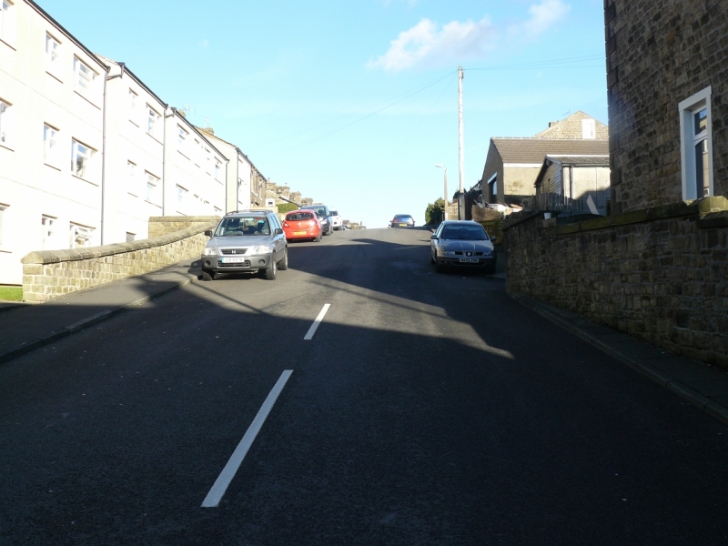
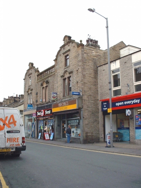
Ridge Street is built on a pronounced ridge - probably the reason for its name. The ridge can be clearly seen in the image of Chapel Street above - the bump just higher up than the red car on the left is the top of the ridge.
I agree that the Romans would not have ignored the natural resources around Barlick - timber and grain but also limestone which the Romans had a massive appetite for. If this was indeed a Roman town then it probably came into being because of its location. From here they could muster the production of materials and transport them - probably to build other Roman centres such as the Elslack fort and Ribchester. As you say, Barlick was noted for its grain and timber production in the medieval and this capacity did not suddenly spring out of nowhere - the probability is that the timber and grain producing system had been in place for a very long time.
Also fascinated to hear that the old footpath over Letcliffe shows signs of having been paved - LiDAR shows the line of the original road extension over Letcliffe as a faint double ditch. I'd also expect a water source to run down from here into the possible town - the Let in Letcliffe could be the Latin word Let meaning leat - also, cliffe is an Old English word commonly applied to earlier defended sites by the English (ie. the Castercliffe hillfort at Colne). I'm sure that any firm dating evidence there might be will be found around Letcliffe.
David - good to hear that you could help with Council permissions over Letcliffe. It would be good to involve a small group of interested local people in fieldwork on the site if possible.
Ridge Street is built on a pronounced ridge - probably the reason for its name. The ridge can be clearly seen in the image of Chapel Street above - the bump just higher up than the red car on the left is the top of the ridge.
-
Wendyf

- Global Moderator
- Posts: 9442
- Joined: 23 Jan 2012, 12:26
- Location: Lower Burnt Hill, looking out over Barlick
Re: EARLY SETTLEMENT IN WEST CRAVEN
I've nothing intelligent to say but am following all this with great interest! Got my boots on ready to field walk....
Looking back in the topic I noticed one of the images from your "EUREKA" post has gone missing, can you post it again John?
Looking back in the topic I noticed one of the images from your "EUREKA" post has gone missing, can you post it again John?
-
John C Layton
- Newbie
- Posts: 54
- Joined: 09 Dec 2015, 15:57
Re: EARLY SETTLEMENT IN WEST CRAVEN
Wendy - have had a look back but can't find a missing image - any idea what it was?
Hopefully you and Margaret will be digging again soon!
Hopefully you and Margaret will be digging again soon!
-
Wendyf
- Global Moderator
- Posts: 9442
- Joined: 23 Jan 2012, 12:26
- Location: Lower Burnt Hill, looking out over Barlick
Re: EARLY SETTLEMENT IN WEST CRAVEN
It followed this paragraph...
EUREKA
I decided this morning to load the new (50cm) LiDAR data into my GIS programme (I've been working with 1m and 2m up to now) - I'm glad that I made the effort as the early settlement of Barnoldswick shows through loud and clear. The image shows the defended area of St. Mary's Mount and a series of linked defensive sites (shown hatched) connected by a rectlinear enclosure.
-
John C Layton
- Newbie
- Posts: 54
- Joined: 09 Dec 2015, 15:57
Re: EARLY SETTLEMENT IN WEST CRAVEN
OK Wendy - done it (at least I think I have).
-
John C Layton
- Newbie
- Posts: 54
- Joined: 09 Dec 2015, 15:57
Re: EARLY SETTLEMENT IN WEST CRAVEN
Barlick Lake
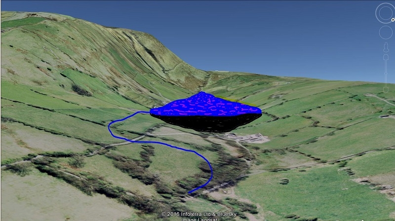
In a very early post within this forum I posted a LiDAR of Weets showing an area suitable for water collection. Exaggerating the contours in Google Earth it's possible to see how this might have worked. Damming across the valley above Moor Close would produce a massive head of water which might have been brought down via a leat at Moor Close Farm (Stanley - I sent you images of this a few weeks ago). This would have allowed for serioes water and saw mill operations in Barlick. Not sure if this is feasible on the ground but thought I'd put it out there.
Speaking of mills - it is certain that the major reason for Barlick being sited here is the hill-water system. If we have a Roman town origin then the two waterways could well have supported corn and saw milling at this time.
-
Stanley
- Global Moderator
- Posts: 90295
- Joined: 23 Jan 2012, 12:01
- Location: Barnoldswick. Nearer to Heaven than Gloria.
Re: EARLY SETTLEMENT IN WEST CRAVEN
There's a lot to get my head round!
In my supporting evidence yesterday I forgot to flag up that Park Avenue is also the logical extension of the old Bronze age route over Weets and via Longfield Lane and Forty Steps.
My impression of paving on Letcliffe Park could be later activity as the route into the park from the back of Hill Top farm was developed as a picturesque walk when the Council took over the land in 1900. It follows a much earlier right of way and there is still a small branch of it near Hill Top farm down onto Barnoldswick Lane. I was asked for an opinion on it many years ago and said it was important and should be retained.
Water on Letcliffe. Letcliffe obviously gathers water and sheds it. I am most familiar with the water that flows westwards, down onto Barnoldswick Lane. In ver wet weather a lot of water leaches out of the existing bank onto the road and runs away down the paved surface. There are two big stone drains in Hey Farm Field on the other side of the road which run down into Gillians Beck running in the valley at the bottom of the field before turning down Ouzledale. That field is marked on the 18th century deeds as The Flows'. I know nothing of water flows to the East or the North.
There is evidence of a spring on top of Letcliffe. If you follow the path from the Hill Top entrance along the boundary fence to the small car park at the far end where there is a path branching off down to the east to join what was Hodge Lane. (This is where the two ancient stones guard the way through the wall onto this path) Between this gap in the wall and the small car park is a piece of land which in wet weather becomes very boggy. Just what you'd expect if there was a partially blocked land drain at that point but due to the slope, if such a drain exists it will be running South or South East.
In terms of a water supply for the fort, Gillians is too low to serve it directly and from the contours, any direct supply would have to be from the direction of Letcliffe and it would surprise me if such a flow didn't exist but has now been buried under the modern (1900 onwards) development of the ground between there and Letcliffe.
Back Lane was the original name for Philip Street and it's noteworthy that a connection still exists between it and the top of Newtown which was the original main route out to Skipton and Gisburn down the side of the Craven Court building..
Going back to water. Many years ago I stumbled across an account of a report made by a water engineer. I think it was when the Council were investigating augmenting the town water supply and eventually settled on the Elslack reservoir scheme. In the report the engineer proposed a reservoir up the hill from the town impounding the water of Gillians Beck but of course Elslack was the eventual choice.
One thought worth bearing in mind. Thinking about possible remnants of evidence of a fort, whenever such a construction was abandoned the building materials were re-used and always downhill from the original site. Therefore it's reasonable to assume that older buildings downhill from the site would be good candidates for recycled Roman stone. Such a building is the row of houses at the end of King Street backing on to Philip Street, the southern extent of the fort. There are some very old stones used in these houses including the back wall and capstones on Philip Street which have always puzzled me because I can't identify them beyond the fact that they are obviously recycled masonry.
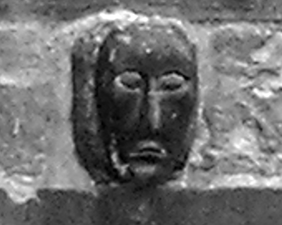
There is also the stone head incorporated in the back wall of Hudson's Buildings.
Keep this thread going!
In my supporting evidence yesterday I forgot to flag up that Park Avenue is also the logical extension of the old Bronze age route over Weets and via Longfield Lane and Forty Steps.
My impression of paving on Letcliffe Park could be later activity as the route into the park from the back of Hill Top farm was developed as a picturesque walk when the Council took over the land in 1900. It follows a much earlier right of way and there is still a small branch of it near Hill Top farm down onto Barnoldswick Lane. I was asked for an opinion on it many years ago and said it was important and should be retained.
Water on Letcliffe. Letcliffe obviously gathers water and sheds it. I am most familiar with the water that flows westwards, down onto Barnoldswick Lane. In ver wet weather a lot of water leaches out of the existing bank onto the road and runs away down the paved surface. There are two big stone drains in Hey Farm Field on the other side of the road which run down into Gillians Beck running in the valley at the bottom of the field before turning down Ouzledale. That field is marked on the 18th century deeds as The Flows'. I know nothing of water flows to the East or the North.
There is evidence of a spring on top of Letcliffe. If you follow the path from the Hill Top entrance along the boundary fence to the small car park at the far end where there is a path branching off down to the east to join what was Hodge Lane. (This is where the two ancient stones guard the way through the wall onto this path) Between this gap in the wall and the small car park is a piece of land which in wet weather becomes very boggy. Just what you'd expect if there was a partially blocked land drain at that point but due to the slope, if such a drain exists it will be running South or South East.
In terms of a water supply for the fort, Gillians is too low to serve it directly and from the contours, any direct supply would have to be from the direction of Letcliffe and it would surprise me if such a flow didn't exist but has now been buried under the modern (1900 onwards) development of the ground between there and Letcliffe.
Back Lane was the original name for Philip Street and it's noteworthy that a connection still exists between it and the top of Newtown which was the original main route out to Skipton and Gisburn down the side of the Craven Court building..
Going back to water. Many years ago I stumbled across an account of a report made by a water engineer. I think it was when the Council were investigating augmenting the town water supply and eventually settled on the Elslack reservoir scheme. In the report the engineer proposed a reservoir up the hill from the town impounding the water of Gillians Beck but of course Elslack was the eventual choice.
One thought worth bearing in mind. Thinking about possible remnants of evidence of a fort, whenever such a construction was abandoned the building materials were re-used and always downhill from the original site. Therefore it's reasonable to assume that older buildings downhill from the site would be good candidates for recycled Roman stone. Such a building is the row of houses at the end of King Street backing on to Philip Street, the southern extent of the fort. There are some very old stones used in these houses including the back wall and capstones on Philip Street which have always puzzled me because I can't identify them beyond the fact that they are obviously recycled masonry.
There is also the stone head incorporated in the back wall of Hudson's Buildings.
Keep this thread going!
Stanley Challenger Graham
Stanley's View
scg1936 at talktalk.net
"Beware of certitude" (Jimmy Reid)
The floggings will continue until morale improves!
Stanley's View
scg1936 at talktalk.net
"Beware of certitude" (Jimmy Reid)
The floggings will continue until morale improves!
-
John C Layton
- Newbie
- Posts: 54
- Joined: 09 Dec 2015, 15:57
Re: EARLY SETTLEMENT IN WEST CRAVEN
As you say Stanley, the paved footpath could have been part of the public park and this will be the problem with fieldwork here - sorting the ancient features from the modern landscaping. Plans of the park development would be a great asset as would resources such as tithe and survey maps. It certainly appears that the early routes conform to the enclosure.
I've attached an image below - exaggerated contour image of Letcliffe and the proposed Roman town site with a watercourse evident on LiDAR and air pics running into the 'town' - does this make any sense Stanley?
Interesting that Philip St. was originally Back Lane - this suggests that medieval development turned its back on the enclosure south of Philip Street. I'm sure it is right that some early stone would find its way into the modern buildings but it's difficult to sort early functional building stone from later worked stone. In cases of high status, such as abbey buildings, the buildings contained a large amount of high quality carved and dressed stonework and some of this naturally found its way into the later local buildings. However, the stonework of a Roman town would be largely confined to a couple of principia buildings and the main town walls. These walls would be part of a ditch system around 3 m deep with a possible flagged stone walkway around the edge of the ditch. As enclosed towns fell out of use the British natives, and Anglo-Saxon settlers, would use any surviving stonework to fill in the ditches and to construct their new roads. Hence, the vast majority of Roman period stone will be buried beneath the modern town. That said, some stone would remain in use as Stanley suggests.
I'm interested to know the origins of the Town Square area - whether it was originally as we now see it, or was it constructed through demolition of properties etc.?
The carved head on Hudsons Buildings is fascinating - I wish I'd looked at this the other day when I was over there. Although the image that Stanley posted is somewhat under par (not his fault I'm sure) there is enough detail to make an educated guess at the origin of the thing. As Plaques quite rightly pointed out earlier in this forum, early carved heads, and those placed on modern buldings for ornamentation, often share a defined style.
'Celtic Head' is the name given to a whole genre of stone carvings where a stylised face is carved on a block of stone. The genuine Celtic Heads were created by an Iron Age culture whose fascination with the human head is well documented within archaeology. The majority of surviving carved heads within museums etc. are commonly given the blanket term 'Celtic Head' in the same manner that all vacuum cleaners are referred to as 'Hoovers.'
Another problem with heads set into buildings is that the original carved head was invariably trimmed down to fit the building stone course - this means we have lost half of the artefact. However, I'll stick my neck out on the Hudson Building head and say that it is early. The style and relationship of the features, along with the manner in which the face relates to the base-block, suggests that the face has a British origin with Roman influence - in other words, Romano-British.
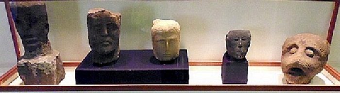
So called local 'Celtic Heads' in Craven Museum (image Ray Spencer).
The above image of 'Celtic Heads' in the Skipton Museum does not actually contain any genuine Celtic Heads. The one on the right is a fascinating if most peculiar style with a decidedly eastern influence while the three left are Roman with a similar possible Romano-British example 2nd right (similar to the Hudson Building example). If my description is right then the Hudson head would fit perfectly with the occupation period of the proposed Roman town at Barnoldswick. Is it possible that this head was found when the foundations for Hudsons Building were being dug?
A head from the Roman period was discovered at Hague (Kelbrook) - this is a depiction of an African person and could have been the property of a foreign Roman soldier or, more likely, a god.
I've attached an image below - exaggerated contour image of Letcliffe and the proposed Roman town site with a watercourse evident on LiDAR and air pics running into the 'town' - does this make any sense Stanley?
Interesting that Philip St. was originally Back Lane - this suggests that medieval development turned its back on the enclosure south of Philip Street. I'm sure it is right that some early stone would find its way into the modern buildings but it's difficult to sort early functional building stone from later worked stone. In cases of high status, such as abbey buildings, the buildings contained a large amount of high quality carved and dressed stonework and some of this naturally found its way into the later local buildings. However, the stonework of a Roman town would be largely confined to a couple of principia buildings and the main town walls. These walls would be part of a ditch system around 3 m deep with a possible flagged stone walkway around the edge of the ditch. As enclosed towns fell out of use the British natives, and Anglo-Saxon settlers, would use any surviving stonework to fill in the ditches and to construct their new roads. Hence, the vast majority of Roman period stone will be buried beneath the modern town. That said, some stone would remain in use as Stanley suggests.
I'm interested to know the origins of the Town Square area - whether it was originally as we now see it, or was it constructed through demolition of properties etc.?
The carved head on Hudsons Buildings is fascinating - I wish I'd looked at this the other day when I was over there. Although the image that Stanley posted is somewhat under par (not his fault I'm sure) there is enough detail to make an educated guess at the origin of the thing. As Plaques quite rightly pointed out earlier in this forum, early carved heads, and those placed on modern buldings for ornamentation, often share a defined style.
'Celtic Head' is the name given to a whole genre of stone carvings where a stylised face is carved on a block of stone. The genuine Celtic Heads were created by an Iron Age culture whose fascination with the human head is well documented within archaeology. The majority of surviving carved heads within museums etc. are commonly given the blanket term 'Celtic Head' in the same manner that all vacuum cleaners are referred to as 'Hoovers.'
Another problem with heads set into buildings is that the original carved head was invariably trimmed down to fit the building stone course - this means we have lost half of the artefact. However, I'll stick my neck out on the Hudson Building head and say that it is early. The style and relationship of the features, along with the manner in which the face relates to the base-block, suggests that the face has a British origin with Roman influence - in other words, Romano-British.
So called local 'Celtic Heads' in Craven Museum (image Ray Spencer).
The above image of 'Celtic Heads' in the Skipton Museum does not actually contain any genuine Celtic Heads. The one on the right is a fascinating if most peculiar style with a decidedly eastern influence while the three left are Roman with a similar possible Romano-British example 2nd right (similar to the Hudson Building example). If my description is right then the Hudson head would fit perfectly with the occupation period of the proposed Roman town at Barnoldswick. Is it possible that this head was found when the foundations for Hudsons Building were being dug?
A head from the Roman period was discovered at Hague (Kelbrook) - this is a depiction of an African person and could have been the property of a foreign Roman soldier or, more likely, a god.
-
David Whipp
- Senior Member
- Posts: 2874
- Joined: 19 Oct 2012, 18:26
Re: EARLY SETTLEMENT IN WEST CRAVEN
Thank John.
I'll ask what documents/plans the council has for Letcliffe Park.
The Town Square is a modern development, celebrating its 25th anniversary last year. It was created on the site of a large co-op building that used to dominate Albert Road.
I'll ask what documents/plans the council has for Letcliffe Park.
The Town Square is a modern development, celebrating its 25th anniversary last year. It was created on the site of a large co-op building that used to dominate Albert Road.
-
John C Layton
- Newbie
- Posts: 54
- Joined: 09 Dec 2015, 15:57
Re: EARLY SETTLEMENT IN WEST CRAVEN
OK David - that's brilliant - thanks.
-
PanBiker
- Site Administrator
- Posts: 16447
- Joined: 23 Jan 2012, 13:07
- Location: Barnoldswick - In the West Riding of Yorkshire, always was, always will be.
Re: EARLY SETTLEMENT IN WEST CRAVEN
Her we go John, a couple of images from the gallery (Big Kev), this is the old Coop building on Albert Road, one from each side of the frontage.
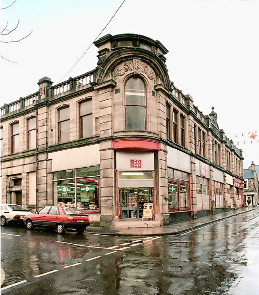
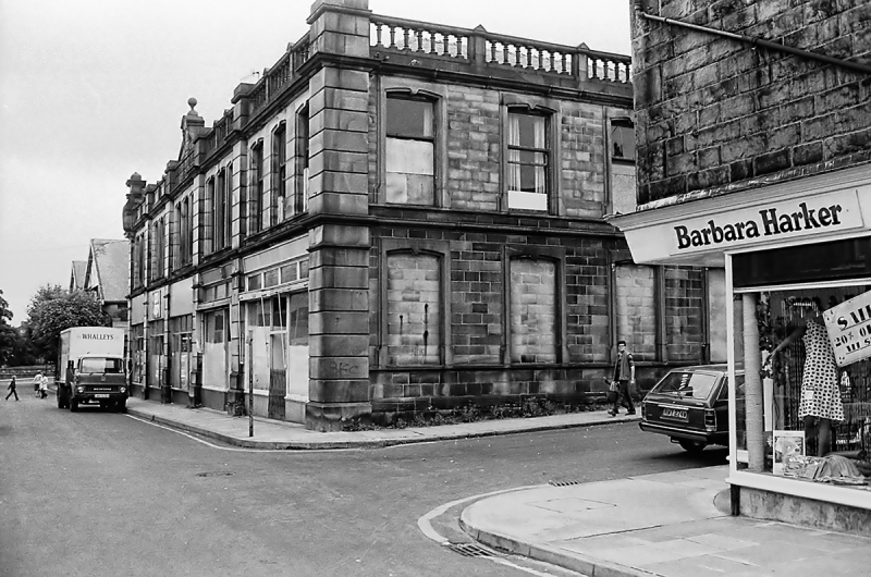
The building was relatively modern being built in 1909, the date stone is retained on the back perimeter wall of the square.
The mock Tudor buildings at the end of Albert Road were built by Matt Hartley, the block on the same side as the former Coop used to house the Majestic Cinema and Ballroom, you can still see where the original entrance was on the frontage. Matt Hartley was quite prolific in his building contributions around town. There is another one of his at the other end of Albert Road on the corner of Newtown
and then again another block on Church Street.
They all date from the first decade of the 20th century.
Back to your work, it's fascinating what you are turning up. You can count me in for boots on the ground as well if required.
Ian

Re: EARLY SETTLEMENT IN WEST CRAVEN
John,, perhaps a very naive questions. How and where would they bury their dead? Also is there any clues to where their rubbish tips may be?
-
Stanley
- Global Moderator
- Posts: 90295
- Joined: 23 Jan 2012, 12:01
- Location: Barnoldswick. Nearer to Heaven than Gloria.
Re: EARLY SETTLEMENT IN WEST CRAVEN
The head was pulled out of another picture John, hence the lack of definition.
As for the blue lines on your image of the fort and Letcliffe. I'm having difficulty orienting myself, I can't really recognise features I know are there. I suspect that the line on the right down to the fort area is the old track down the back of Hill Top. The blue line down through the Flows, the field at Hey Farm looks about right for one of the big field drains.
As for the blue lines on your image of the fort and Letcliffe. I'm having difficulty orienting myself, I can't really recognise features I know are there. I suspect that the line on the right down to the fort area is the old track down the back of Hill Top. The blue line down through the Flows, the field at Hey Farm looks about right for one of the big field drains.
Stanley Challenger Graham
Stanley's View
scg1936 at talktalk.net
"Beware of certitude" (Jimmy Reid)
The floggings will continue until morale improves!
Stanley's View
scg1936 at talktalk.net
"Beware of certitude" (Jimmy Reid)
The floggings will continue until morale improves!
Re: EARLY SETTLEMENT IN WEST CRAVEN
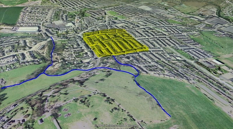
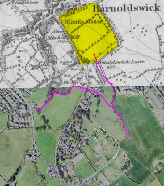
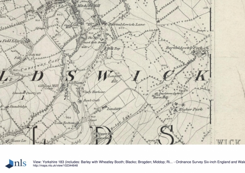
Looking at the Lancashire Mario maps, the early Yorkshire addition, The area on John's map marked yellow almost equates to the area bounded by : Barnoldswick Lane, Blue Pot Lane, and Back lane. This area also carries a caption ' Monks House'. I don't know whether if any of this is relevant or just a coincident.
-
John C Layton
- Newbie
- Posts: 54
- Joined: 09 Dec 2015, 15:57
Re: EARLY SETTLEMENT IN WEST CRAVEN
Thanks Ian for the Co-op images - looks like it was an impressive building. Glad to hear you're up for a field survey - perhaps the weather might be suitable in another month or so.
Stanley - you did well to get that head image from that photo. Having seen it in more context I'm going to backtrack on the Romano-British date and suggest either 8-10th century or a much later carving. Also - it appears to have been painted black?
Plaques - a good question. When it comes to the Iron Age British natives there is no clear-cut answer to how they buried their dead. Each district tended to have their own methods but there doesn't appear to have been any standardised burial practice such as we saw in the Bronze Age (cremated burials within mounds). Iron Age cremations and burials have been found, along with body deposition within water sites, but by and large it is still a mystery as to how and where the majority of the Iron Age population were buried. Their waste was disposed of in middens around the settlements and also in large pits within settlement boundaries. These may have been former grain pits reused for waste disposal?
In relation to a Roman town the official burial practice was interment in graves a short distance beyond the town walls. It is almost certain that somewhere within a radius of say 1,000 yards from the present town square there will be grave areas dating to the Roman and Saxon periods. It is also worth considering where the dead were buried when St Mary's in Barlick was occupied by monks?
Stanley - hope this image clarifies things. The white line is an enclosure around the summit of Letcliffe Hill and the blue follows a possible water course S to N along the eastern flank of the hill and across Par Avenue.
-
David Whipp
- Senior Member
- Posts: 2874
- Joined: 19 Oct 2012, 18:26
Re: EARLY SETTLEMENT IN WEST CRAVEN
Plaques, Monks House is a building to the left of the caption (on modern day Manchester Road).
-
Stanley
- Global Moderator
- Posts: 90295
- Joined: 23 Jan 2012, 12:01
- Location: Barnoldswick. Nearer to Heaven than Gloria.
Re: EARLY SETTLEMENT IN WEST CRAVEN
John, I see now why I was having a problem. The proposed water course is outside the boundary of the park. If you project the NE white line delineating the summit forward to the Back Lane behind Hill Top Farm that's the park Boundary and the line of the track that is an extension of the back lane.
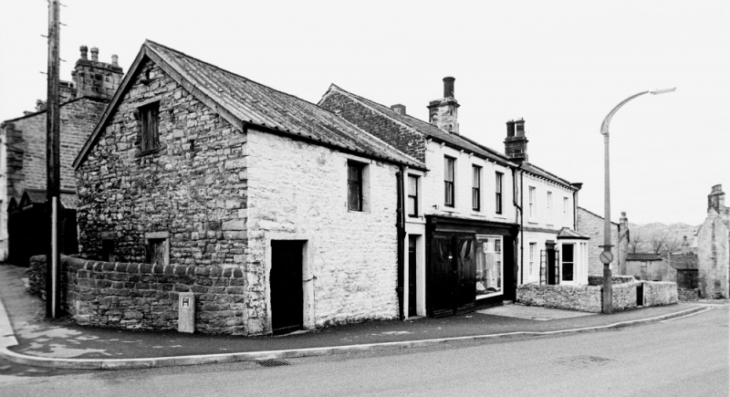
P. Monks House on the right and the adjoining shop and barn in 1984.
P. Monks House on the right and the adjoining shop and barn in 1984.
Stanley Challenger Graham
Stanley's View
scg1936 at talktalk.net
"Beware of certitude" (Jimmy Reid)
The floggings will continue until morale improves!
Stanley's View
scg1936 at talktalk.net
"Beware of certitude" (Jimmy Reid)
The floggings will continue until morale improves!
-
David Whipp
- Senior Member
- Posts: 2874
- Joined: 19 Oct 2012, 18:26
Re: EARLY SETTLEMENT IN WEST CRAVEN
Staff at Pendle have emailed me a pdf of a map of the Letcliffe area said to be from 1849.
I don't think this adds much to what's known about the area. They are looking to see if there's anything in the records.
I don't think this adds much to what's known about the area. They are looking to see if there's anything in the records.
-
John C Layton
- Newbie
- Posts: 54
- Joined: 09 Dec 2015, 15:57
Re: EARLY SETTLEMENT IN WEST CRAVEN
Thanks for the map David - useful for locating lost tracks etc. - all maps and plans gratefully received.
I was in Foulridge this afternoon so had a look up at Letcliffe. This confirmed a niggling notion I've had since I started looking at the area through LiDAR. A quick look at the landscape confirmed the strong possibility that Letcliffe Park covers the central enclosure of a Bronze Age defended settlement cum Iron Age hillfort.
Heading up the old track from Hilltop Farm into the park (shown on David's map) it is clear that this was cobbled for the length up the break of slope. On the level, east of the car parks, the surface shows evidence of either having been paved with stones - there is the caveat, though, that these earthbound stones may be the remains of a collapsed fied wall. That said, Stanley pointed out two large upright stones in the style in this boundary - these are very early (Bronze Age?) markers or suvivors of the original inner defensive wall around the level enclosure that is now the main letcliffe Park. On the east slope below this are signs of a filled ditch running around the contour towards Hey farm.
Within this outer ditch is a mahusive ditch running down from the lane from Hill Top - this has been maintained as a drain but the shape and depth of the ditch suggest and original defensive purpose. ON the LiDAR this ditch can be seen to form part of an oval encosure which could very well be a Bronze Age farmstead.

Here are the above features - white line = oval enclosure Yello line = poss. paved inner enclosure ditch and wall, later a trackway Black line = outer ditch Blue area = Letcliffe Park bounds Red area = area of farmland.
The Red area of land above probably contains the evidence required to date the Letcliffe site and the proposed enclosed settlement between Park Avenue and Chapel Street. So ... anyone know who owns the land and would it be possible for us to get permission to fieldwalk it?
. . . . . . . . . . . . . . . . . . . .
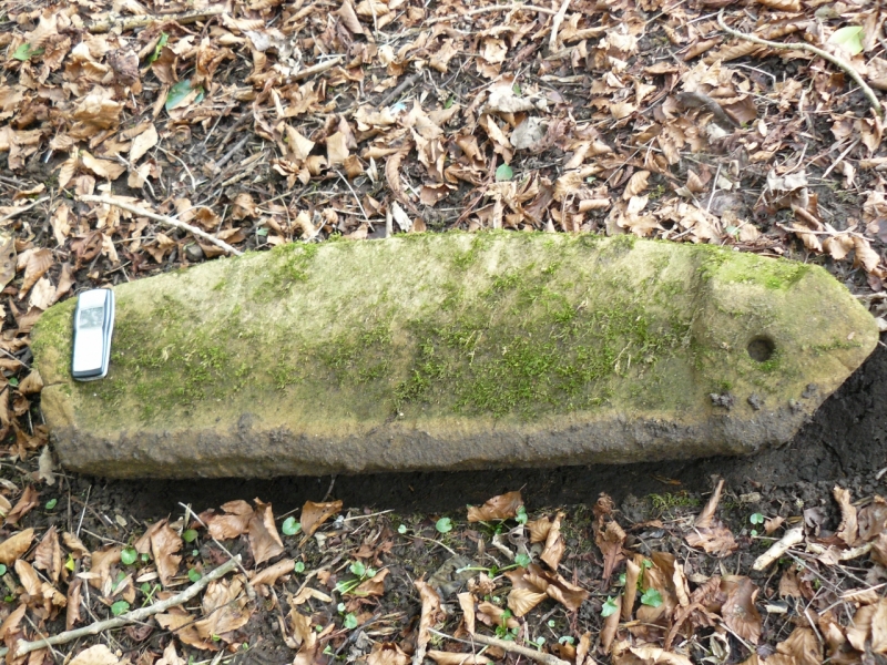
As a matter of interest, I wondered if anybody can identify this stone I found in the woodland at Letcliffe, below the 'amphitheatre.' This is one of an exact pair. The back of the stones are curved in the form of Saxon hogshead gravestones which got me all excited - until I noticed that the flat base is concrete! Very odd - the stones are shaped at each end and have a circular drilled hole around 2 inches deep. They are soft sandstone and might have been set in concrete as a feature in the park at some time? A series of them laid flat would form a circular feature. I have not yet written these off as modern just yet as there are very old stones scattered around the area.
I was in Foulridge this afternoon so had a look up at Letcliffe. This confirmed a niggling notion I've had since I started looking at the area through LiDAR. A quick look at the landscape confirmed the strong possibility that Letcliffe Park covers the central enclosure of a Bronze Age defended settlement cum Iron Age hillfort.
Heading up the old track from Hilltop Farm into the park (shown on David's map) it is clear that this was cobbled for the length up the break of slope. On the level, east of the car parks, the surface shows evidence of either having been paved with stones - there is the caveat, though, that these earthbound stones may be the remains of a collapsed fied wall. That said, Stanley pointed out two large upright stones in the style in this boundary - these are very early (Bronze Age?) markers or suvivors of the original inner defensive wall around the level enclosure that is now the main letcliffe Park. On the east slope below this are signs of a filled ditch running around the contour towards Hey farm.
Within this outer ditch is a mahusive ditch running down from the lane from Hill Top - this has been maintained as a drain but the shape and depth of the ditch suggest and original defensive purpose. ON the LiDAR this ditch can be seen to form part of an oval encosure which could very well be a Bronze Age farmstead.
Here are the above features - white line = oval enclosure Yello line = poss. paved inner enclosure ditch and wall, later a trackway Black line = outer ditch Blue area = Letcliffe Park bounds Red area = area of farmland.
The Red area of land above probably contains the evidence required to date the Letcliffe site and the proposed enclosed settlement between Park Avenue and Chapel Street. So ... anyone know who owns the land and would it be possible for us to get permission to fieldwalk it?
. . . . . . . . . . . . . . . . . . . .
As a matter of interest, I wondered if anybody can identify this stone I found in the woodland at Letcliffe, below the 'amphitheatre.' This is one of an exact pair. The back of the stones are curved in the form of Saxon hogshead gravestones which got me all excited - until I noticed that the flat base is concrete! Very odd - the stones are shaped at each end and have a circular drilled hole around 2 inches deep. They are soft sandstone and might have been set in concrete as a feature in the park at some time? A series of them laid flat would form a circular feature. I have not yet written these off as modern just yet as there are very old stones scattered around the area.
-
PanBiker
- Site Administrator
- Posts: 16447
- Joined: 23 Jan 2012, 13:07
- Location: Barnoldswick - In the West Riding of Yorkshire, always was, always will be.
Re: EARLY SETTLEMENT IN WEST CRAVEN
I think the land will be owned by the farm or smallholding at the end of Hodge Lane just below the bottom of the red area on the map. I walked down Hodge Lane last week and there was a guy, repairing the wall along the lane there, I think he was from the nearby farm.
It's basically what the locals refer to as King Hill and field(s) up to the back of York Fields.
Just looked at the local farmers in Yellowpages online. it's A.S. & R.C. Parnaby, High Croft, Hodge Lane, Barnoldswick 01282 813152
Would be a starting point for making enquiries.
It's basically what the locals refer to as King Hill and field(s) up to the back of York Fields.
Just looked at the local farmers in Yellowpages online. it's A.S. & R.C. Parnaby, High Croft, Hodge Lane, Barnoldswick 01282 813152
Would be a starting point for making enquiries.
Ian