I'm putting this topic up as a vehicle for discussion about pre Conquest settlement in Barlick mainly (But of course it may spill over into the surrounding districts). The primary interest is the meaning and interpretation of new information we are seeing from surveys using the latest methods. John has taken the trouble (and the expense) to get to grips with LIDAR and his preliminary results are throwing up features that I for one knew nothing about.
I believe that he is on to something very important.
The first thing I noticed was that if John is right about settlement then we get the beginnings of an explanation why Shitten Ginnel exists. Even more exciting is that at this point John believes we are looking at a classic early defended settlement.....
Much of what we know depends on the written record of the last 1000 years. What John is uncovering is another set of records, the marks on the ground revealed by LIDAR. This will take us back at least another 1000 years so this could be important!
EARLY SETTLEMENT IN WEST CRAVEN
-
Stanley

- Global Moderator

- Posts: 90375
- Joined: 23 Jan 2012, 12:01
- Location: Barnoldswick. Nearer to Heaven than Gloria.
EARLY SETTLEMENT IN WEST CRAVEN
Stanley Challenger Graham
Stanley's View
scg1936 at talktalk.net
"Beware of certitude" (Jimmy Reid)
The floggings will continue until morale improves!
Stanley's View
scg1936 at talktalk.net
"Beware of certitude" (Jimmy Reid)
The floggings will continue until morale improves!
-
Wendyf

- Global Moderator
- Posts: 9453
- Joined: 23 Jan 2012, 12:26
- Location: Lower Burnt Hill, looking out over Barlick
Re: EARLY SETTLEMENT IN WEST CRAVEN
John has done a lot of work for us in Earby, including the discovery of a possible site of the medieval village.
I very cheekily contacted Chris Gaffney, the head of Archaeological Sciences at Bradford University to see if they could use the site for training students in geophysics and he has agreed to do some work on the field in the spring!
I very cheekily contacted Chris Gaffney, the head of Archaeological Sciences at Bradford University to see if they could use the site for training students in geophysics and he has agreed to do some work on the field in the spring!
-
Wendyf
- Global Moderator
- Posts: 9453
- Joined: 23 Jan 2012, 12:26
- Location: Lower Burnt Hill, looking out over Barlick
Re: EARLY SETTLEMENT IN WEST CRAVEN
LiDAR data is now free to download for anyone Here
-
Stanley
- Global Moderator
- Posts: 90375
- Joined: 23 Jan 2012, 12:01
- Location: Barnoldswick. Nearer to Heaven than Gloria.
Re: EARLY SETTLEMENT IN WEST CRAVEN
I asked John about the availability and he told me that yes, the data was available free online but the problem is that in order to use it you need a special programme and the data for one small tile is 100 smaller files.... I told him I'll appoint him my official LIDAR interpreter as he has taken the trouble to do a course on it!
I'm not going to pre-empt anything John reveals, it'a his project. However let me flag up just two things that puzzled me for years and still do to some extent. If you look at Longfield Lane and Forty steps the line matches exactly with a feature in a field called Causeway Carr at the foot of Folly Lane. That was what triggered me off into walking the line and coming up with my theory about a Bronze Age track-way through Barlick heading directly from Ireland to the Baltic States via the Aire Gap at Kildwick. Again, look at Shitten Ginnel and ask yourself "Why is it there?". From what John has shown me so far I think we are close to getting a back story for the route. These are the sorts of facts that I hope John will lay before us.
I'm not going to pre-empt anything John reveals, it'a his project. However let me flag up just two things that puzzled me for years and still do to some extent. If you look at Longfield Lane and Forty steps the line matches exactly with a feature in a field called Causeway Carr at the foot of Folly Lane. That was what triggered me off into walking the line and coming up with my theory about a Bronze Age track-way through Barlick heading directly from Ireland to the Baltic States via the Aire Gap at Kildwick. Again, look at Shitten Ginnel and ask yourself "Why is it there?". From what John has shown me so far I think we are close to getting a back story for the route. These are the sorts of facts that I hope John will lay before us.
Stanley Challenger Graham
Stanley's View
scg1936 at talktalk.net
"Beware of certitude" (Jimmy Reid)
The floggings will continue until morale improves!
Stanley's View
scg1936 at talktalk.net
"Beware of certitude" (Jimmy Reid)
The floggings will continue until morale improves!
-
John C Layton
- Newbie
- Posts: 54
- Joined: 09 Dec 2015, 15:57
Re: EARLY SETTLEMENT IN WEST CRAVEN
That's right Stanley. For anyone who has previously employed LiDAR from the Environment Agency the EA have recently closed their original site in favour of the one Wendy has linked to. Instead of individual 1k LiDAR tiles at 1 or 2 metres DSM/DTM only large blocks can now be downloaded. More importantly the tiles are no longer supplied in .JPG form - they are now in .ASCII with a further complication of different capture data being stitched together. This means that the later, and more useful, 1 metre data available in some areas have been stitched to 2 metre data thus rendering the whole block as the earliest 2 metre data available.
Furthermore, the .ASCII data is officially 3 band RGB but most mapping software will only recognise it as single band rendering the images useless for any purpose other than very large scale raster geo-spacial interpretation. I have purchased an expensive software licence to manage the new LiDAR data but to me it is worth its weight in gold. So... we now have a fantastic free resource available but with many strings attached!
Furthermore, the .ASCII data is officially 3 band RGB but most mapping software will only recognise it as single band rendering the images useless for any purpose other than very large scale raster geo-spacial interpretation. I have purchased an expensive software licence to manage the new LiDAR data but to me it is worth its weight in gold. So... we now have a fantastic free resource available but with many strings attached!
-
Wendyf
- Global Moderator
- Posts: 9453
- Joined: 23 Jan 2012, 12:26
- Location: Lower Burnt Hill, looking out over Barlick
Re: EARLY SETTLEMENT IN WEST CRAVEN
I haven't tried to download any since it changed. Good job I got all the Earby ones!
-
John C Layton
- Newbie
- Posts: 54
- Joined: 09 Dec 2015, 15:57
Re: EARLY SETTLEMENT IN WEST CRAVEN
This area may well have been swept by a massive wave of water that had built up on Weets behind glaciation within the lower reaches of the town. Meltwater on Weets could have backed up against a cross-flow of Late Devensian ice heading from Barlick to Foulridge thus forming a lake when the ice retreated. Eventually the water would break out on the lower north side of the lake and sweep down to a line between Coverdale and Bracewell Lane (now occupied by the ancient routeway of Brogden lane). To the west the water scoured channels down the hill from Weets into Craven Laithe carrying massive boulders downtream of Admergill and depositing them along Blacko Water. To the east some water broke through the lower end of the lake and made its way along the line of Esp Lane, through Town Head and along the present Rainhall Road. All of this water action served to clear the land of many of its humps and bumps and would replace them with larger areas of gently rising ground made up largely of glacial till. (See Blick Lake 2 image).
Can it be pure coincidence that the relatively level area of land along Gillians Beck around Town Head was the (probable) original Bronze Age - Iron Age then Anglian settlements that became Barnoldswick? The ongoing LiDAR survey of the area is showing defined patterns of early settlement and desertion extending from the Ribble to Barnoldswick and, following discussion of this with Stanley, it seems possible that these ultra-rural populations migrated to Barlick, especially following the expansion of the woollen industry within the later 14th century. All of the 'lost' villages within the area described above were nestled in limited and difficult areas of lowland squeezed between drumlin hills.
So... we might have made a start in getting to grips with why Barlick was located on this site. Incidentally, If I'm correct about the 'lake' feature then Weets Hill must have been twice its present size before the last Ice Age.
You do not have the required permissions to view the files attached to this post.

Re: EARLY SETTLEMENT IN WEST CRAVEN
Knowing next to nothing about the Devensian Ice Age I found this work which demonstrates how complex a subject it is especially in our area of East Lancashire. Devensian John's explanation of how our local terrain is its current shape is a good analysis of what may have taken place. Explaining complex events in simple to understand terms makes any article well worth reading. Keep up the good work.
The extract below has been taken from the reference above.
"Ice moving from the Lake District and Western pennines interacted with an ice stream in the Irish Sea basin
along the western and southern fringes of the region. The sedimentary record is dominated by evidence of a warmbased,
fast-moving, wet ice sheet during this period. While highland areas are dominated by erosion, in valleys and
lowland areas much of the base of the ice sheet is likely to have been underlain by a deforming bed of water saturated
sediment, which would have facilitated rapid ice flow and adjustment to changing mass balance and ice marginal
conditions. This layer of basal sediment was easily sculpted by ice flow, resulting in multiple phases of drumlin
formation. Towards the ice margins, extensive tunnel valleys and meltwater channels indicates that considerable
quantities of water were flushed from the system, depositing extensive outwash deposits beyond the ice
margin. Where the two major ice sheets separated along the western fringes of the area, extensive proglacial lake
sediments were deposited."
-
Stanley
- Global Moderator
- Posts: 90375
- Joined: 23 Jan 2012, 12:01
- Location: Barnoldswick. Nearer to Heaven than Gloria.
Re: EARLY SETTLEMENT IN WEST CRAVEN
Fascinating.... I have a question. Are the images above oriented with North at the top? (By the way, if you click on them you can enlarge them) If so the arrow delineating the glacial axis puzzles me. I would have assumed that when the ice came down it would be moving roughly North to South. I'm obviously not reading something correctly....
Stanley Challenger Graham
Stanley's View
scg1936 at talktalk.net
"Beware of certitude" (Jimmy Reid)
The floggings will continue until morale improves!
Stanley's View
scg1936 at talktalk.net
"Beware of certitude" (Jimmy Reid)
The floggings will continue until morale improves!
-
John C Layton
- Newbie
- Posts: 54
- Joined: 09 Dec 2015, 15:57
Re: EARLY SETTLEMENT IN WEST CRAVEN
My fault Stanley - I did not make this clear - the images are orientated N top, the long east-west double-headed arrow indicates the line of the Roman Road which is also the edge of the drumlin field. The N_S arrow from the box (global axis) is the glacial direction as can be seen from the orientation of the drumlins. Plaques' reference makes good sense in relation to the geology of our area.
-
Stanley
- Global Moderator
- Posts: 90375
- Joined: 23 Jan 2012, 12:01
- Location: Barnoldswick. Nearer to Heaven than Gloria.
Re: EARLY SETTLEMENT IN WEST CRAVEN
Thanks for that John. I'd made that assumption but needed clarification.
Have you cracked posting images?
Ian, can you point John at your excellent guide to image posting? I've sent him mine but yours may solve his problem.
John. If all else fails send them to me and I'll post them for you.....
What we need to get to is an overlay of the modern map on the LIDAR version and then the same map with your putative settlement patterns imposed as well. That's what got me excited...... (then there's the evidence of an Iron Age defended settlement.....)
Stanley Challenger Graham
Stanley's View
scg1936 at talktalk.net
"Beware of certitude" (Jimmy Reid)
The floggings will continue until morale improves!
Stanley's View
scg1936 at talktalk.net
"Beware of certitude" (Jimmy Reid)
The floggings will continue until morale improves!


-
Stanley
- Global Moderator
- Posts: 90375
- Joined: 23 Jan 2012, 12:01
- Location: Barnoldswick. Nearer to Heaven than Gloria.
Re: EARLY SETTLEMENT IN WEST CRAVEN
John has sent me his latest version of settlement at Stock, he is still working on it and promises he will post ASAP. What I have seen is astounding! Keep an eye on this topic because I promise you will be as surprised as I am. He's working very hard on the techniques needed to overlay modern features on the LIDAR image, at the moment even I am having difficulty orienting myself. Be patient, it will all be worth while!
Stanley Challenger Graham
Stanley's View
scg1936 at talktalk.net
"Beware of certitude" (Jimmy Reid)
The floggings will continue until morale improves!
Stanley's View
scg1936 at talktalk.net
"Beware of certitude" (Jimmy Reid)
The floggings will continue until morale improves!
Re: EARLY SETTLEMENT IN WEST CRAVEN
I once got interested in trying to do the same thing with old street maps. At the time I was impressed by the 'Lancashire Mario' maps which enables you to overlay a varying degree of transparency from old to new maps. I tried Photoshop elements but never got past the 'possible' stage before moving on to another project. I would still be interested in how it could be done.Stanley wrote:He's working very hard on the techniques needed to overlay modern features on the LIDAR image, at the moment even I am having difficulty orienting myself.

Re: EARLY SETTLEMENT IN WEST CRAVEN
Layering is quite a simple process in Photoshop (I use CS6). For the Ubuntu users I'm sure you could do it in GIMP as well, as long as you can adjust the opacity of the layers and your maps are all at the same scale.
Kev
Stylish Fashion Icon.

Stylish Fashion Icon.


Re: EARLY SETTLEMENT IN WEST CRAVEN
Yes, Kev, I haven't needed to try it but Gimp has the facility. Modifying opacity is described here: Opacity
and a beginner's tutorial on Gimp layers is here: Gimp layers
and a beginner's tutorial on Gimp layers is here: Gimp layers
Nullius in verba: On the word of no one (Motto of the Royal Society)
-
Stanley
- Global Moderator
- Posts: 90375
- Joined: 23 Jan 2012, 12:01
- Location: Barnoldswick. Nearer to Heaven than Gloria.
Re: EARLY SETTLEMENT IN WEST CRAVEN
I don't want to learn anything more about Gimp but it might be nice if one of you acted as sub-contractor for John..... I'm sure he will read this. It might save him some time.....
Stanley Challenger Graham
Stanley's View
scg1936 at talktalk.net
"Beware of certitude" (Jimmy Reid)
The floggings will continue until morale improves!
Stanley's View
scg1936 at talktalk.net
"Beware of certitude" (Jimmy Reid)
The floggings will continue until morale improves!
-
John C Layton
- Newbie
- Posts: 54
- Joined: 09 Dec 2015, 15:57
Re: EARLY SETTLEMENT IN WEST CRAVEN
Layering images at the most basic level is fine for raster data (image over spacial data such as a map). The LiDAR stuff, however, is geographic vector entry and manipulation into geographic information system software. This means that accurate landscape features can be transferred between images and file types and placed into any map scale or geographic image and can then be stored or shared etc.
Re: EARLY SETTLEMENT IN WEST CRAVEN
"..geographic vector entry and manipulation into geographic information system software.."
Sounds like Major Tim Peake might be needed!
Sounds like Major Tim Peake might be needed!
Nullius in verba: On the word of no one (Motto of the Royal Society)
-
Stanley
- Global Moderator
- Posts: 90375
- Joined: 23 Jan 2012, 12:01
- Location: Barnoldswick. Nearer to Heaven than Gloria.
Re: EARLY SETTLEMENT IN WEST CRAVEN
He's into some heavy stuff Tiz. I have had more images from John and have told him we need a brainstorm. I hope he prises himself away from his computer and comes over so we can unpick the results so far. I am very excited about them but will not post any images until John and I agree that we are getting somewhere near a true picture. For instance, yesterday he sent me very good evidence of a water power site at a location that had never occurred to me. It is entirely feasible and explains features of the site that have always intrigued me. Better than sex......!!
Stanley Challenger Graham
Stanley's View
scg1936 at talktalk.net
"Beware of certitude" (Jimmy Reid)
The floggings will continue until morale improves!
Stanley's View
scg1936 at talktalk.net
"Beware of certitude" (Jimmy Reid)
The floggings will continue until morale improves!
-
John C Layton
- Newbie
- Posts: 54
- Joined: 09 Dec 2015, 15:57
Re: EARLY SETTLEMENT IN WEST CRAVEN
I agree that all this geographic information stuff sounds like waffle! Difficult to describe it otherwise really - I suppose that simply put the aim of digital geography in archaeology is to create your own accurate interactive maps of a particular area. On a wider scale geographers us this to map continental or local flooding, assess soil conditions in drought areas, group any type of data onto maps (such as demographics or even types of car ownership etc.). It's possible to download almost-live satellite images to do this.
-
John C Layton
- Newbie
- Posts: 54
- Joined: 09 Dec 2015, 15:57
Re: EARLY SETTLEMENT IN WEST CRAVEN
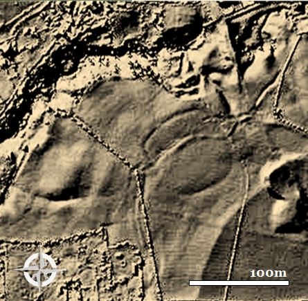
Image of Middle Bronze Age ditched farmstead settlement at Clough Head, Nelson. A short distance to the south of this is the lost village of Laughton and just to the east is the former manor house of Townhouse. This displays a continual series of settlements in a small area ranging from 3,000 BC to the end of the Medieval.
NORTH WEST SETTLEMENT IN BRIEF
PART ONE
Early Development
The reasons for the settlement patterns of North West England are many and varied - existing towns, villages and hamlets all share a common history, some extending back 7,000 years while others have been created within the last one hundred and fifty years. Each modern settlement stands as testimony to its original founders but what of our older towns, villages and hamlets – and the surprisingly large number of lost or abandoned occupation sites? It is easy to glance at a map showing a network of urban sprawl and rural villages, interconnected by a vast network of roads, and not give it a second thought – this is the 20th century landscape we grew up in and, for us at least, it has always been like this.
Historians and archaeologists can also fall into the trap of taking modern settlement patterns for granted – all too often the lives of our ancient forebears are separated from ours in a way that severs any connection between us. Early villages may be excavated and abandoned sites noted but this does nothing to tell the story of the countless generations of people who settled within our district, cleared the heavy woodlands with stone tools, created the field patterns that can still be recognised today and formulated the system of farming, industry and culture that still dictates our modern lives.
Aerial imaging (particularly LiDAR aerial laser imaging) has transformed the discipline of landscape archaeology – fieldwork is all well and good when a site is known but is severely limited when it comes to actually locating landscape features on the ground. Employing LiDAR across a large area of our Lancashire-Yorkshire border district it is clear that the early settlement pattern of this area is far more complex than previously thought. We (the Burnley, Pendle and West Craven Archaeology Project) have, to date, discovered at least ten lost or shrunken villages. Examining the images of these ghostly outlines of once thriving communities serves to highlight the fact that our modern world did not simply appear from the ether – it is based on the hard work and tenacity of others.
The lost/abandoned villages we can now see were social links between our prehistory and the growth of the Industrial Age. A successful settlement needed the basics of water supply, shelter from the prevailing winds, well-drained productive land, large areas of standing woodland and good road or sea communications with the outside world. It also needed a socio-political system that did not break the will of the lowly cottars – the church was an invaluable element in this. Above all, perhaps, the settlement also needed luck – some villages appear to have fared worse than others in times of plague pandemics while the micro-climate of one village might protect against the worst effects of crop failure and famine compared to a neighbouring village. There were also the pressures of invasion by Angles, Saxons and Normans plus numerous attacks by pillagers from north of the border.
Archaeologists have discovered a large number of pre-historic settlements on the bleak upland moors that do not conform to the modern idea of a suitable site. This inclined 19th century antiquarians to the view that anyone who would set up camp in what are now the most desolate areas of our hills and moors must have been semi-wild idiots. Even well into the 20th century distinguished archaeologists often shared this view, hence Sir Mortimer Wheeler’s description of our Iron Age ancestors as being ‘capering ninnies covered in woad.’
Thankfully much progress has been made toward understanding the lives of settlers within the (British) Neolithic, Bronze Age and Iron Age (c. 4,000 BC to 45AD). Study of weather patterns, pollen, soil and seed analysis, the lifestyle of individuals evident within their bones, woodland clearance and new sub-surface land survey methods have shown that the upper reaches of our moorlands and higher hills were well populated for a period of some 4,000 years. These people did not survive in animal skin shelters, living off berries and nuts – they occupied stone and timber houses on favourable upland sites of woodland and grassland close to watercourses within a far more temperate climate than that of our modern day.
As metal-working technology advanced new ploughs were able to work previously untenable soils and so the Iron Age has left us not only with scattered groupings of small patchwork fields but also larger arable areas on the outer community land fringes. Modern archaeological survey methods show that there are numerous Iron Age settlements, with related field systems, within our district and that many of these continued through the Roman period (as Romano British villages) and into the Dark Age (Early Medieval) period.
Aerial landscape survey provides us with (in many cases) the only evidence for early settlement patterns. There is little recorded evidence for North Western rural settlement prior to the 11th century Domesday Book and even this is severely limited in the information it carries for the Lancashire-Yorkshire border area. From the 12th century there is an increasing corpus of written record relating to landholding and it becomes increasingly easier for the historian to tell the story of a village or town down the centuries into the Modern period.
Our problem, then, is to locate deserted or lost settlements and to relate these to the modern settlement patterns. There is no firm template for the assessment of a lost Romano British village, nor do Anglo Saxon villages give up their secrets easily - each site is unique. That said, a certain pattern of village development is to be expected within all periods – settlements need streets, houses, stock enclosures, agricultural buildings, defences, water supply, external trackways and industrial areas for kilns and metal working.
By the time of the Iron Age, and its attendant unsettled weather patterns, most of the earlier upland settlements had migrated down from the uplands and moorlands into the more productive land of the valleys. For a period roughly covering the period of the first millennium BC it was common practice for communities to build hillforts to provide defensive foci for the occupants of settlements within the area. It is not clear whether the hillforts were erected purely in reaction to a raised threat of inter-tribal violence or simply as a sop to a prevailing fashion for showing off the status of a community. Aerial LiDAR evidence has been instrumental in locating at least twelve previously unknown hillfort features within the area extending from Burnley to Hellifield; many of these also have attendant lost settlement systems. There is a strong suggestion, then, that there were far more Iron Age and Romano British villages within our district than the official archaeological records would have us believe.
So. . . we have a precedent for continual occupation of our land from at least 4,000 BC through to the 5th century AD when the Romans departed our sylvan shores. At this time we were a predominantly British people ruling the area through a series of minor British kingdoms. The name Brigantes is often bandied about in relation to this but there is a strong argument in favour of this simply being a description of the tribal confederacy occupying our northern upland areas. In reality there were numerous tribal estates within minor kingdoms; the area extending from Earby to the Ribble and Middop to Hellifield appears to have been an estate within the kingdom of Craven. There is no known political or regal centre relating to Craven but over the summer of 2015 we (the BPC Archaeology Project) carried out archaeological work within the district extending from Gisburn to Long Preston. Here we found evidence to suggest that this area was of much higher status than previously realised and may well have been the ‘capital’ of the Craven kingdom.
In the century or two following the Roman departure our area would have comprised of hamlets and scattered individual farmsteads set amongst small enclosed fields. Hollow ways (sunken tracks) led from the settlements up onto the open cattle grazing areas of the high ground. Towards the end of the 600s AD Anglo Saxon culture began to move into our northern district but it is widely thought that the British kingdom of Elmet, part of the old West Riding of Yorkshire around Leeds, was still 'British' at the start of the 7th century. However, by this time the Angles had invaded West Craven from their base in East Anglia – this was the first British kingdom to be taken in our area. Modern place-names around Gisburn and Barnoldswick still betray their Anglian roots. It is possible that no change was wrought in settlement type or pattern by the Anglian take-over of the region, but whatever the degree of settlement continuity the names of the settlements today are, as they were in 1086 in Domesday Book, predominantly Anglian (Hoober for example is pure Anglian).
There are two striking patterns to settlements extant within this period – the planned or nucleated settlement and the piecemeal development of dispersed settlement. Planned (nucleated) settlements follow the pattern easily recognised within our modern towns and villages where uniform streets are lined with buildings and a central area of common land (the village green); the lord of the manor would live on the edge of the community alongside his own fields and the church building would offer a defined foci for village life. This type of village was often created from scratch by feudal landlords or their local retainers. It has been suggested that most planned villages were a result of rebuilding following the ravages of Malcolm III’s invasion in 1061 or because of the deliberate wasting of our district by the Normans. However, there is no firm evidence for this – ‘planned’ settlements may have evolved at any time from the 9th century onwards.
The ‘unplanned’ sites can be seen to have grown without regulation or pattern; usually these were a loose grouping of widely scattered houses and farmsteads within a roughly central landholding. The related village would grow through a need for communal effort within farming practice – where the ground was heavy it was necessary to employ large plough teams of up to eight or ten oxen. Grouping the farm workers’ houses around a single farm unit (a yard, barn, grain/feed/tool stores etc.) allowed the workers to share the expense of the draught animals and plough equipment. The remnants of this system can still be seen in local farm buildings carrying the name ‘Fold’ – more often than not these are farm buildings and cottages arranged around a communal yard.
Having set the scene, so to speak, we can now look at the LiDAR evidence for the lost village sites within our area and attempt to make sense of why they occupied a particular landscape location, what was the story relating to the life of the village and why did it become deserted?
ReferencesPART ONE
Early Development
The reasons for the settlement patterns of North West England are many and varied - existing towns, villages and hamlets all share a common history, some extending back 7,000 years while others have been created within the last one hundred and fifty years. Each modern settlement stands as testimony to its original founders but what of our older towns, villages and hamlets – and the surprisingly large number of lost or abandoned occupation sites? It is easy to glance at a map showing a network of urban sprawl and rural villages, interconnected by a vast network of roads, and not give it a second thought – this is the 20th century landscape we grew up in and, for us at least, it has always been like this.
Historians and archaeologists can also fall into the trap of taking modern settlement patterns for granted – all too often the lives of our ancient forebears are separated from ours in a way that severs any connection between us. Early villages may be excavated and abandoned sites noted but this does nothing to tell the story of the countless generations of people who settled within our district, cleared the heavy woodlands with stone tools, created the field patterns that can still be recognised today and formulated the system of farming, industry and culture that still dictates our modern lives.
Aerial imaging (particularly LiDAR aerial laser imaging) has transformed the discipline of landscape archaeology – fieldwork is all well and good when a site is known but is severely limited when it comes to actually locating landscape features on the ground. Employing LiDAR across a large area of our Lancashire-Yorkshire border district it is clear that the early settlement pattern of this area is far more complex than previously thought. We (the Burnley, Pendle and West Craven Archaeology Project) have, to date, discovered at least ten lost or shrunken villages. Examining the images of these ghostly outlines of once thriving communities serves to highlight the fact that our modern world did not simply appear from the ether – it is based on the hard work and tenacity of others.
The lost/abandoned villages we can now see were social links between our prehistory and the growth of the Industrial Age. A successful settlement needed the basics of water supply, shelter from the prevailing winds, well-drained productive land, large areas of standing woodland and good road or sea communications with the outside world. It also needed a socio-political system that did not break the will of the lowly cottars – the church was an invaluable element in this. Above all, perhaps, the settlement also needed luck – some villages appear to have fared worse than others in times of plague pandemics while the micro-climate of one village might protect against the worst effects of crop failure and famine compared to a neighbouring village. There were also the pressures of invasion by Angles, Saxons and Normans plus numerous attacks by pillagers from north of the border.
Archaeologists have discovered a large number of pre-historic settlements on the bleak upland moors that do not conform to the modern idea of a suitable site. This inclined 19th century antiquarians to the view that anyone who would set up camp in what are now the most desolate areas of our hills and moors must have been semi-wild idiots. Even well into the 20th century distinguished archaeologists often shared this view, hence Sir Mortimer Wheeler’s description of our Iron Age ancestors as being ‘capering ninnies covered in woad.’
Thankfully much progress has been made toward understanding the lives of settlers within the (British) Neolithic, Bronze Age and Iron Age (c. 4,000 BC to 45AD). Study of weather patterns, pollen, soil and seed analysis, the lifestyle of individuals evident within their bones, woodland clearance and new sub-surface land survey methods have shown that the upper reaches of our moorlands and higher hills were well populated for a period of some 4,000 years. These people did not survive in animal skin shelters, living off berries and nuts – they occupied stone and timber houses on favourable upland sites of woodland and grassland close to watercourses within a far more temperate climate than that of our modern day.
As metal-working technology advanced new ploughs were able to work previously untenable soils and so the Iron Age has left us not only with scattered groupings of small patchwork fields but also larger arable areas on the outer community land fringes. Modern archaeological survey methods show that there are numerous Iron Age settlements, with related field systems, within our district and that many of these continued through the Roman period (as Romano British villages) and into the Dark Age (Early Medieval) period.
Aerial landscape survey provides us with (in many cases) the only evidence for early settlement patterns. There is little recorded evidence for North Western rural settlement prior to the 11th century Domesday Book and even this is severely limited in the information it carries for the Lancashire-Yorkshire border area. From the 12th century there is an increasing corpus of written record relating to landholding and it becomes increasingly easier for the historian to tell the story of a village or town down the centuries into the Modern period.
Our problem, then, is to locate deserted or lost settlements and to relate these to the modern settlement patterns. There is no firm template for the assessment of a lost Romano British village, nor do Anglo Saxon villages give up their secrets easily - each site is unique. That said, a certain pattern of village development is to be expected within all periods – settlements need streets, houses, stock enclosures, agricultural buildings, defences, water supply, external trackways and industrial areas for kilns and metal working.
By the time of the Iron Age, and its attendant unsettled weather patterns, most of the earlier upland settlements had migrated down from the uplands and moorlands into the more productive land of the valleys. For a period roughly covering the period of the first millennium BC it was common practice for communities to build hillforts to provide defensive foci for the occupants of settlements within the area. It is not clear whether the hillforts were erected purely in reaction to a raised threat of inter-tribal violence or simply as a sop to a prevailing fashion for showing off the status of a community. Aerial LiDAR evidence has been instrumental in locating at least twelve previously unknown hillfort features within the area extending from Burnley to Hellifield; many of these also have attendant lost settlement systems. There is a strong suggestion, then, that there were far more Iron Age and Romano British villages within our district than the official archaeological records would have us believe.
So. . . we have a precedent for continual occupation of our land from at least 4,000 BC through to the 5th century AD when the Romans departed our sylvan shores. At this time we were a predominantly British people ruling the area through a series of minor British kingdoms. The name Brigantes is often bandied about in relation to this but there is a strong argument in favour of this simply being a description of the tribal confederacy occupying our northern upland areas. In reality there were numerous tribal estates within minor kingdoms; the area extending from Earby to the Ribble and Middop to Hellifield appears to have been an estate within the kingdom of Craven. There is no known political or regal centre relating to Craven but over the summer of 2015 we (the BPC Archaeology Project) carried out archaeological work within the district extending from Gisburn to Long Preston. Here we found evidence to suggest that this area was of much higher status than previously realised and may well have been the ‘capital’ of the Craven kingdom.
In the century or two following the Roman departure our area would have comprised of hamlets and scattered individual farmsteads set amongst small enclosed fields. Hollow ways (sunken tracks) led from the settlements up onto the open cattle grazing areas of the high ground. Towards the end of the 600s AD Anglo Saxon culture began to move into our northern district but it is widely thought that the British kingdom of Elmet, part of the old West Riding of Yorkshire around Leeds, was still 'British' at the start of the 7th century. However, by this time the Angles had invaded West Craven from their base in East Anglia – this was the first British kingdom to be taken in our area. Modern place-names around Gisburn and Barnoldswick still betray their Anglian roots. It is possible that no change was wrought in settlement type or pattern by the Anglian take-over of the region, but whatever the degree of settlement continuity the names of the settlements today are, as they were in 1086 in Domesday Book, predominantly Anglian (Hoober for example is pure Anglian).
There are two striking patterns to settlements extant within this period – the planned or nucleated settlement and the piecemeal development of dispersed settlement. Planned (nucleated) settlements follow the pattern easily recognised within our modern towns and villages where uniform streets are lined with buildings and a central area of common land (the village green); the lord of the manor would live on the edge of the community alongside his own fields and the church building would offer a defined foci for village life. This type of village was often created from scratch by feudal landlords or their local retainers. It has been suggested that most planned villages were a result of rebuilding following the ravages of Malcolm III’s invasion in 1061 or because of the deliberate wasting of our district by the Normans. However, there is no firm evidence for this – ‘planned’ settlements may have evolved at any time from the 9th century onwards.
The ‘unplanned’ sites can be seen to have grown without regulation or pattern; usually these were a loose grouping of widely scattered houses and farmsteads within a roughly central landholding. The related village would grow through a need for communal effort within farming practice – where the ground was heavy it was necessary to employ large plough teams of up to eight or ten oxen. Grouping the farm workers’ houses around a single farm unit (a yard, barn, grain/feed/tool stores etc.) allowed the workers to share the expense of the draught animals and plough equipment. The remnants of this system can still be seen in local farm buildings carrying the name ‘Fold’ – more often than not these are farm buildings and cottages arranged around a communal yard.
Having set the scene, so to speak, we can now look at the LiDAR evidence for the lost village sites within our area and attempt to make sense of why they occupied a particular landscape location, what was the story relating to the life of the village and why did it become deserted?
Clayton J. Archaeology of Burnley and Pendle (Part One and Part Two) Barrowford Press 2014
Graham S. C. Barnoldswick - The Story of a Pennine Town SP Amazon 2008
Gelling M. & Cole A. The Landscape of Place-names Shaun Tyas Stamford 2000
Kenyon D. The Origins of Lancashire Manchester University Press 1991
Newman R. (ed.) The Archaeology of Lancashire Lancaster University Archaeological Unit 1996
-
Wendyf
- Global Moderator
- Posts: 9453
- Joined: 23 Jan 2012, 12:26
- Location: Lower Burnt Hill, looking out over Barlick
Re: EARLY SETTLEMENT IN WEST CRAVEN
Sorted the photo for you John.
-
John C Layton
- Newbie
- Posts: 54
- Joined: 09 Dec 2015, 15:57
Re: EARLY SETTLEMENT IN WEST CRAVEN
Thanks Wendy - I didn't know the actual image appeared within the post - thought it should just be a link.
-
Wendyf
- Global Moderator
- Posts: 9453
- Joined: 23 Jan 2012, 12:26
- Location: Lower Burnt Hill, looking out over Barlick
Re: EARLY SETTLEMENT IN WEST CRAVEN
Click on the the "mountain & sun" icon On the toolbar then paste in the link to your image.