Favourite Walks and Rambles

Re: Favourite Walks and Rambles
We've run into some problems in Cornwall where we couldn't continue walks that we were following from the OS map and have ended up in dangerous situations. If we've already walked a long way or up and down hills I can't follow the route back because of my breathing problems, so we have to find a way onwards. Once we were forced to jay walk along a main, busy and fast, A road for the final stretch - a frightening experience! Another time we had to climb over a 6-foot high chain link fence topped with barbed wire by climbing onto a dry stone wall, negotiating the wire and then lowering ourselves down the other side. No fun! In both cases there were no signs warning us in advance and no diversions shown.
Nullius in verba: On the word of no one (Motto of the Royal Society)
-
David Whipp
- Senior Member
- Posts: 2874
- Joined: 19 Oct 2012, 18:26
Re: Favourite Walks and Rambles
A resident from Ribble Valley contacted my about the solar park development, but it was after all the planning had been dealt with. I was surprised that we hadn't been formally consulted by RV about it. Any impact on a public right of way is something that has to be taken into account when deciding planning applications. I'd have expected a suitable diversion having to be put in place and/or a formal temporary closure if needed during construction.
-
PanBiker

- Site Administrator

- Posts: 16447
- Joined: 23 Jan 2012, 13:07
- Location: Barnoldswick - In the West Riding of Yorkshire, always was, always will be.
Re: Favourite Walks and Rambles
I would have thought that as well David, Richard says one of the solar developments is built right across what was the public right of way and is fenced off. No diversion notices in place. I might not have time to walk down there this next week before I start my exam work up at school so I might drive down to Coalpit and have a look for myself and then report on the LCC site if it is warranted.
Ian
-
Wendyf

- Global Moderator

- Posts: 9442
- Joined: 23 Jan 2012, 12:26
- Location: Lower Burnt Hill, looking out over Barlick
Re: Favourite Walks and Rambles
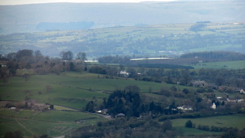
This was my view at 5 o clockish this evening. Is it the solar farm?
-
PanBiker
- Site Administrator
- Posts: 16447
- Joined: 23 Jan 2012, 13:07
- Location: Barnoldswick - In the West Riding of Yorkshire, always was, always will be.
Re: Favourite Walks and Rambles
Very similar to the view off Dark Hill Wendy but you are a bit further away, I assume you have zoomed in a bit.
One of the Lancashire Evening Telegraph Articles
One of the Lancashire Evening Telegraph Articles
Ian
-
PanBiker
- Site Administrator
- Posts: 16447
- Joined: 23 Jan 2012, 13:07
- Location: Barnoldswick - In the West Riding of Yorkshire, always was, always will be.
Re: Favourite Walks and Rambles
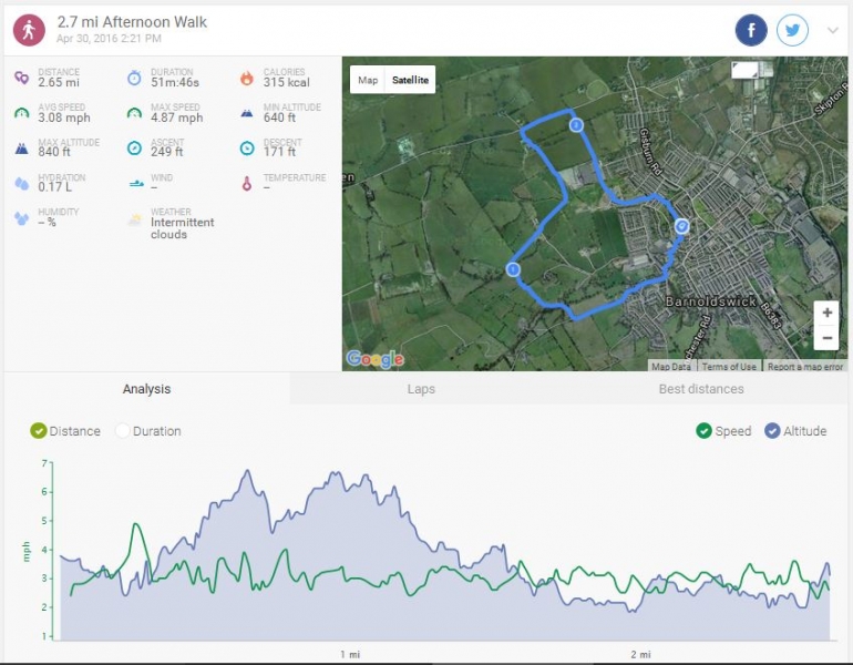
Spring decided to show it's face again this afternoon so we booted up and went for a quick circular around the Western and Northern edges of town. Esp Lane, Hollins, Brogden, Ferbank. 2.7miles in lovely sunshine, a tad over 50 minutes.
Ian
-
PanBiker
- Site Administrator
- Posts: 16447
- Joined: 23 Jan 2012, 13:07
- Location: Barnoldswick - In the West Riding of Yorkshire, always was, always will be.
Re: Favourite Walks and Rambles
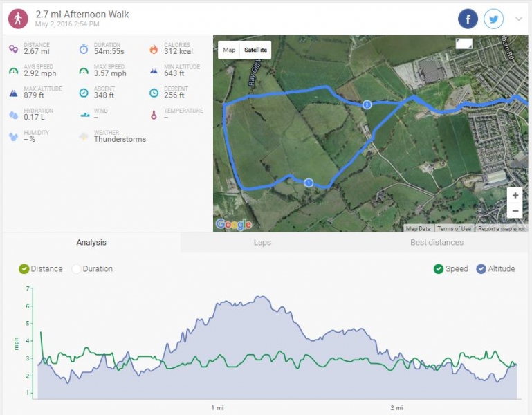
The day got better into the afternoon, so we donned our boots and did a quick circular. Out via the stable behind Priory Way and into the fields. Up to Cow Pasture through the stock paddock and up the path to Hollins Lane and the farm. Back into the field and pick up the bridleway, followed it down towards Raygill but turned right at the bottom of the hill back into the fields. Returning over the boggy field down to the stile under the trees to the old orchard then retrace our steps back via the stables, Valley Gardens and home. 2.7miles, 54min. Sun and cloud, stiff breeze in parts but warm enough.
Ian
-
PanBiker
- Site Administrator
- Posts: 16447
- Joined: 23 Jan 2012, 13:07
- Location: Barnoldswick - In the West Riding of Yorkshire, always was, always will be.
Re: Favourite Walks and Rambles
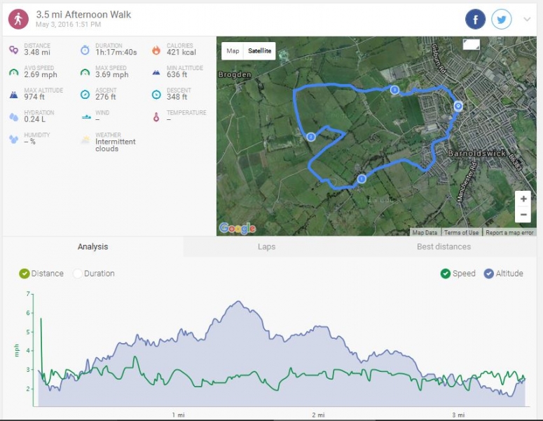
Back in the fields for today's walk. A lovely afternoon when the sun made it through the clouds, bit of a breeze but very pleasant. I set off up Westgate and then onto Moorgate but I took the stile by Billycocks old house and over the fields onto Esp Lane. I continued up to Moor Close and then onto Edge Lane, down into the bottom over the beck and then followed up past Edge House then cut across the field where the lane bends for Far Newfield Edge to pick up the path for my favorite stile at the top of Dark Hill. I came down as far as the stile around the old limestone workings (Humpty Dumpties) of my youth, and a well used picnic spot for countless Barlickers in days gone by, now all fenced off and out of bounds. Onto the lane and up to Hollins, round onto the bridleway and then the rest of the walk a repeat of yesterday, returning below Cow Pasture and round via the stables and home. The variation in the route added just short of another mile on to take the walk to 3.5 miles, 1h 17min, rabbits galore and plenty of muck spreading going on.
Ian
-
Wendyf
- Global Moderator
- Posts: 9442
- Joined: 23 Jan 2012, 12:26
- Location: Lower Burnt Hill, looking out over Barlick
Re: Favourite Walks and Rambles
Eight and a half miles along Hadrians Wall from Housesteads back to Haltwhistle for me and my friend Joanna. We were walking into a strong headwind and now and again it lashed with rain and soaked us, but magnificent views!
-
Stanley

- Global Moderator
- Posts: 90300
- Joined: 23 Jan 2012, 12:01
- Location: Barnoldswick. Nearer to Heaven than Gloria.
Re: Favourite Walks and Rambles
I am envious Wendy.....
Stanley Challenger Graham
Stanley's View
scg1936 at talktalk.net
"Beware of certitude" (Jimmy Reid)
The floggings will continue until morale improves!
Stanley's View
scg1936 at talktalk.net
"Beware of certitude" (Jimmy Reid)
The floggings will continue until morale improves!
-
PanBiker
- Site Administrator
- Posts: 16447
- Joined: 23 Jan 2012, 13:07
- Location: Barnoldswick - In the West Riding of Yorkshire, always was, always will be.
Re: Favourite Walks and Rambles
Yes, sounds nice Wendy, we have been promising ourselves something similar. Sally fancied doing some part of the Cleveland Way over a few days as well. It's finding time to fit it all in with various grand parenting rolls over the summer. I'll have to settle for getting them all up Penyghent.
Ian
-
Wendyf
- Global Moderator
- Posts: 9442
- Joined: 23 Jan 2012, 12:26
- Location: Lower Burnt Hill, looking out over Barlick
Re: Favourite Walks and Rambles
We visited the Roman military museum yesterday morning then walked back along the Wall, this time with the wind behind us which made it easier. We were surprised to find we had walked nearly six miles. Today we take the bus east to Birdoswald and walk back to the museum. We bought a three day pass on the bus that zips up and down the central section of the wall on an hourly basis so we are using it as much as possible.....great fun. Lovely to walk with an old friend who I don't see very often.
-
Wendyf
- Global Moderator
- Posts: 9442
- Joined: 23 Jan 2012, 12:26
- Location: Lower Burnt Hill, looking out over Barlick
Re: Favourite Walks and Rambles
It was a gentler 4 mile walk yesterday through lower rolling countryside but I missed being up on the ridge! We then jumped on the bus and went to Vindolanda spending a couple of hours wandering around the fort and vicus before getting the next bus up to Twice Brewed, the hotel on the military road. The bus was then heading in the wrong direction towards Hexham, so we were obliged to sit out in the garden supping their special beer for an hour till it came back to deliver us to Haltwhistle. 
My feet started to complain while we were at the fort, which disappointed me as I was feeling pretty chuffed with my level of fitness.
My feet started to complain while we were at the fort, which disappointed me as I was feeling pretty chuffed with my level of fitness.
-
PanBiker
- Site Administrator
- Posts: 16447
- Joined: 23 Jan 2012, 13:07
- Location: Barnoldswick - In the West Riding of Yorkshire, always was, always will be.
Re: Favourite Walks and Rambles
Sounds lovely Wendy, I wouldn't have too much of a downer about your feet. You have put quite a few miles in over consecutive days so your feet have a perfect right to complain bit. You have the promised nice weather to come back to as well. I bet Dennis and Sparky are loving it!
Ian
-
PanBiker
- Site Administrator
- Posts: 16447
- Joined: 23 Jan 2012, 13:07
- Location: Barnoldswick - In the West Riding of Yorkshire, always was, always will be.
Re: Favourite Walks and Rambles
We walked on Monday and Tuesday, went for an 18 mile bike ride on Wednesday, I was on my feet for 5 hours straight each day on Thursday and Friday invigilating an exam and Sally did an hours swimming on Friday. Consequently we only felt like a short walk today.
We did a partial repeat of one I did the other day, up Westgate, Esp Lane to the top then up Edge Lane before making for Dark Hill back towards town. Readers of the thread will know of the boggy stile on Dark Hill below where the well rises. They will also know that I have reported it for maintenance due to the duckboards on the approach and exit requiring replacement. Now, how many times have I traversed this stile? It must be dozens of times just in the last few years. The approach from the top was relatively dry, ground still very spongy as it sits on top of a very high water table at that point. The exit side is always badly waterlogged and the existing duckboards are completely submerged under the mire, you can just see them under the surface coating of mud.
I hopped over the stile today and stepped on the first board but when I went for the second I hit the side and my left leg went straight down into the mire to half way up my calf. The mud closed up the hole my boot had made on the way down and I was stuck fast. My right leg was still on the duckboard but bent at the knee. There was nothing to hold on to to help me out. It was good job Sally was with me or I would have had to kneel down so I could use my arms for leverage. As it was it took Sally all her strength to pull my leg up to free me, the suction of the peaty mud was amazing. After extraction I went down to the beck and washed as much as I could off my boot.
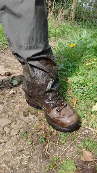
I have to say that even being in the muck that deep my boots still kept the water out. We returned via the path down to Cow Pasture and then the bottom field down to the Stables, Valley Gardens and home. I'll not put the track up as it's already in the thread, just over 2.5 miles on this one, tee shirt weather, warm and fine.
I pulled the hose reel out to the street grate when I got home and swilled my boots, socks and most of the crud of my trousers. Socks, walking pants and my windproof jacket which I had tied round my waist and managed to drag that in the mire as well all ended up in the washer.
We did a partial repeat of one I did the other day, up Westgate, Esp Lane to the top then up Edge Lane before making for Dark Hill back towards town. Readers of the thread will know of the boggy stile on Dark Hill below where the well rises. They will also know that I have reported it for maintenance due to the duckboards on the approach and exit requiring replacement. Now, how many times have I traversed this stile? It must be dozens of times just in the last few years. The approach from the top was relatively dry, ground still very spongy as it sits on top of a very high water table at that point. The exit side is always badly waterlogged and the existing duckboards are completely submerged under the mire, you can just see them under the surface coating of mud.
I hopped over the stile today and stepped on the first board but when I went for the second I hit the side and my left leg went straight down into the mire to half way up my calf. The mud closed up the hole my boot had made on the way down and I was stuck fast. My right leg was still on the duckboard but bent at the knee. There was nothing to hold on to to help me out. It was good job Sally was with me or I would have had to kneel down so I could use my arms for leverage. As it was it took Sally all her strength to pull my leg up to free me, the suction of the peaty mud was amazing. After extraction I went down to the beck and washed as much as I could off my boot.
I have to say that even being in the muck that deep my boots still kept the water out. We returned via the path down to Cow Pasture and then the bottom field down to the Stables, Valley Gardens and home. I'll not put the track up as it's already in the thread, just over 2.5 miles on this one, tee shirt weather, warm and fine.
I pulled the hose reel out to the street grate when I got home and swilled my boots, socks and most of the crud of my trousers. Socks, walking pants and my windproof jacket which I had tied round my waist and managed to drag that in the mire as well all ended up in the washer.
Ian
-
PanBiker
- Site Administrator
- Posts: 16447
- Joined: 23 Jan 2012, 13:07
- Location: Barnoldswick - In the West Riding of Yorkshire, always was, always will be.
Re: Favourite Walks and Rambles
Yesterdays walk had me setting off in the slight drizzle in the afternoon. It was one of those days when you can't quite make your mind up what to wear. I settled on base layer tee shirt and cagoule. It was plenty warm enough as I set off my usual route up Westgate then Moorview and Folly, up the steps below Standridge and into the field. Some nice fencing and side drainage underway on the track from Folly to Lower Standridge. Through the gate by the house and down to the bridge over Gillians Beck, a couple more fields then out onto Lane Bottoms. I went up onto the heather moor and climbed towards Prospect and the stile in the corner of the moor to take me over to Higher View there was a stiff breeze coming across the moor. I noticed a solitary cow in the meadow over the wall a field out from the lane, she looked like a young heifer in calf for the first time. She was in labour and doing a bit of moaning with her contractions I watched her for a while but it looked like she was in the early stages, she was continuing to graze between her contractions and she moved off further into the field so no photo of a newly born calf. It started to rain again as I made my way over and back onto Folly. I returned down the lane back to Moorgate and home. It's a bit of a panhandled route but has a decent climb. No track, it's already in the thread, 3.5miles in just over an hour on a warm (when out of the breeze) but overcast drizzly afternoon.
Ian
-
PanBiker
- Site Administrator
- Posts: 16447
- Joined: 23 Jan 2012, 13:07
- Location: Barnoldswick - In the West Riding of Yorkshire, always was, always will be.
Re: Favourite Walks and Rambles
Same walk as the previous one today but in better weather, dryer but a little cooler in the breeze. More or less the same time for the circuit, 656ft climb, best pace 3.7mph, no rush on a lovely day like today.
Ian
-
PanBiker
- Site Administrator
- Posts: 16447
- Joined: 23 Jan 2012, 13:07
- Location: Barnoldswick - In the West Riding of Yorkshire, always was, always will be.
Re: Favourite Walks and Rambles
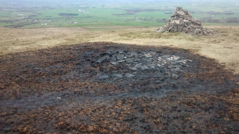
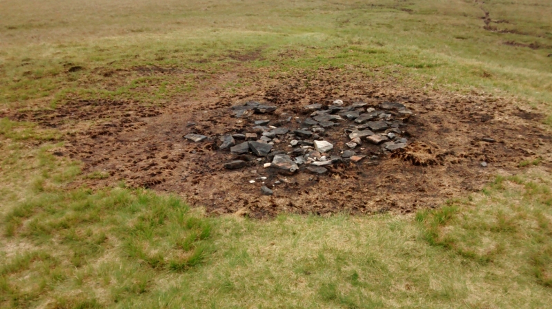
I went on a Weets circular last Tuesday to check one or two things out and lend a bit of exercise for my back. Straight up the ridge via Folly to the trig. Interesting to see how the moor has recovered at the beacon site. Here is the photo taken a couple of days after the event followed by the one I took on Tuesday. Just over a month between the photos.
I came across the moor and then down to Duckpond to checkout the bridleway at the very top of Folly Lane. There is some talk over in local Facebook land regarding a couple of local routes that could possibly benefit from having their current statuses altered on the definitive public rights of way map.
The top of Folly is a case in point. Both Folly lane and Lister Well Road have bridleway status so are navigable the whole of their lengths on horseback. Folly Lane terminates at the top with a gate and a stile at the side. The footpath here runs diagonally across the field to the corner of the perimeter fence of Duckpond. The bridleway actually extends through the gate straight to the perimeter fence then turns 90 degrees to the left to meet the track at Duckpond at the same point as the footpath.
Now here is the crux, the track the runs from Lister Well to Prospect House and then up to Duckpond is used for vehicular access to each of the properties. Livestock is kept in the surrounding fields and there is a cattle grid half way down the track between the two properties to stop beasts straying, there is a bypass gate adjacent to the cattle grid which I believe is currentl kept locked.
It would be an enhancement for the horse riding community if there was a link between the two bridleways. The current status of the track between Duckpond and Lister Well is quite surprising when you consult the definitive map, it's official status is "footpath" which actually means what is says on the tin and should only be open to pedestrian traffic. So, in effect, the owners at Prospect and Duckpond are using the track illegally as are the mountain bikers, quads and anyone one else apart from pedestrians. The status should really be changed on the definitive map to reflect current use and it could also include horse traffic if upgraded to a more suitable category.
I have suggested this over in FB land to interested parties who have posted in the thread. Anyone can make an application to alter the definitive map if they they have good cause or think it is in error. This qualifies in both cases. I hope my suggestions don't just amount to "You can lead a horse to water ......."
Anyway, I returned down Folly to Higher View then came back over the moor to Lane Bottom. I followed the lane to Manchester Road then dodged down Colne Road, Fortysteps, Ouzledale, Clough and home. Just short of 5 miles, pleasant walk on a dry day, eased my back up a bit more as well.
Ian
-
Stanley
- Global Moderator
- Posts: 90300
- Joined: 23 Jan 2012, 12:01
- Location: Barnoldswick. Nearer to Heaven than Gloria.
Re: Favourite Walks and Rambles
I remember HAPPA complaining about the surface of Lister Well Lane being too slippy for horses.... Caused Doc some grief for a while. I don't know what the outcome was....
Stanley Challenger Graham
Stanley's View
scg1936 at talktalk.net
"Beware of certitude" (Jimmy Reid)
The floggings will continue until morale improves!
Stanley's View
scg1936 at talktalk.net
"Beware of certitude" (Jimmy Reid)
The floggings will continue until morale improves!
-
Wendyf
- Global Moderator
- Posts: 9442
- Joined: 23 Jan 2012, 12:26
- Location: Lower Burnt Hill, looking out over Barlick
Re: Favourite Walks and Rambles
I remember that happening. It wouldn't have been HAPPA though Stanley they are just a rescue charity, more likely to have been the local bridleways association or the BHS (British Horse Society).
-
PanBiker
- Site Administrator
- Posts: 16447
- Joined: 23 Jan 2012, 13:07
- Location: Barnoldswick - In the West Riding of Yorkshire, always was, always will be.
Re: Favourite Walks and Rambles
Whoever it was they need to be looking at applying for a change to the definitive map to link the two bridleways. Prospect was the first to be built followed by Duckpond according to the historical mapping. The track was just up to Prospect and of course would carry horse traffic at the time. It was extended later when Duckpond was built further up. Strange though that it is not marked as a track only a footpath. As the "footpath" has been improved to allow vehicular access no one has ever bothered to change it's status. A change of status and the lock taken off the bypass gate and the horse riders would have a lot more scope. All manner of vehicles use the footpath at the moment to get up on the moor but the original users can't, seems daft to me.
I believe the gate at the top of Folly used to be locked but that was challenged by Tom Partridge as it was impeding the bridleway. It is not locked now, I checked when I came down the other day.
I believe the gate at the top of Folly used to be locked but that was challenged by Tom Partridge as it was impeding the bridleway. It is not locked now, I checked when I came down the other day.
Ian
-
Stanley
- Global Moderator
- Posts: 90300
- Joined: 23 Jan 2012, 12:01
- Location: Barnoldswick. Nearer to Heaven than Gloria.
Re: Favourite Walks and Rambles
When I was delivering groceries to Duckpond with the van access was from Folly Lane but I remember going up there with Doc a few years ago and that access is now disused. (I'm trying to remember the bloke's name who lived there on his own, it will come! He was a bit of a curio....)
Stanley Challenger Graham
Stanley's View
scg1936 at talktalk.net
"Beware of certitude" (Jimmy Reid)
The floggings will continue until morale improves!
Stanley's View
scg1936 at talktalk.net
"Beware of certitude" (Jimmy Reid)
The floggings will continue until morale improves!
-
PanBiker
- Site Administrator
- Posts: 16447
- Joined: 23 Jan 2012, 13:07
- Location: Barnoldswick - In the West Riding of Yorkshire, always was, always will be.
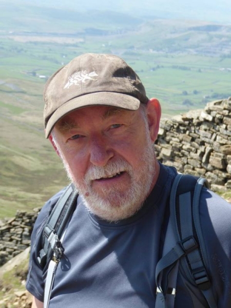
Re: Favourite Walks and Rambles
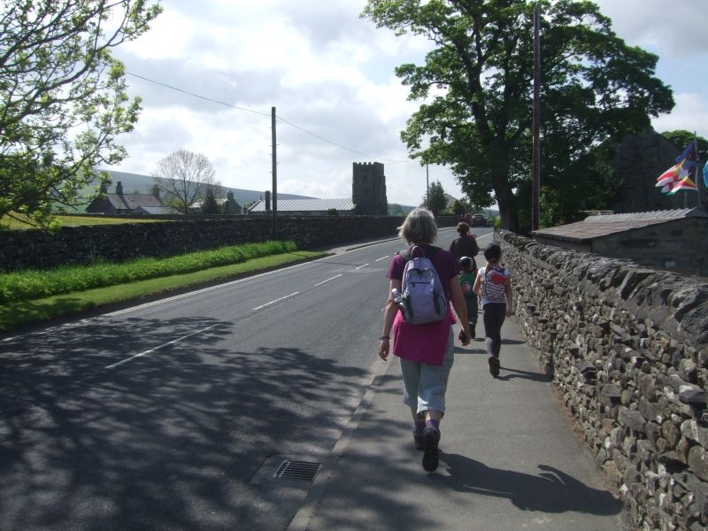
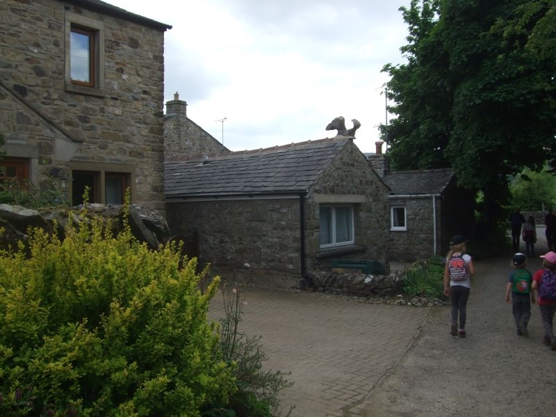
We made it up to Horton in Ribblesdale for our Penyghent circular by 10.30. We managed to find a slot on the car park in the village and after togging up we set off back up the road towards the church.
Over the road and through the gate to take us to the meadow path.
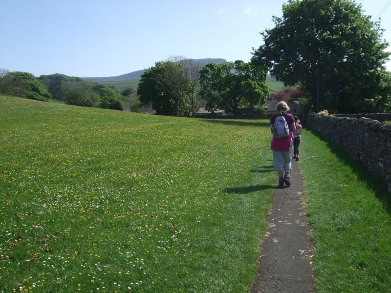
Gate through to Brackenbottom.
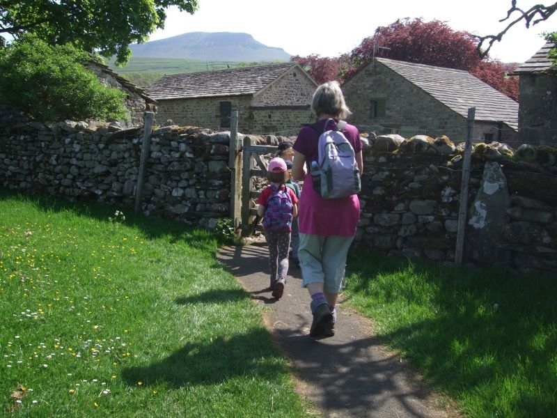
Brackenbottom Lane.
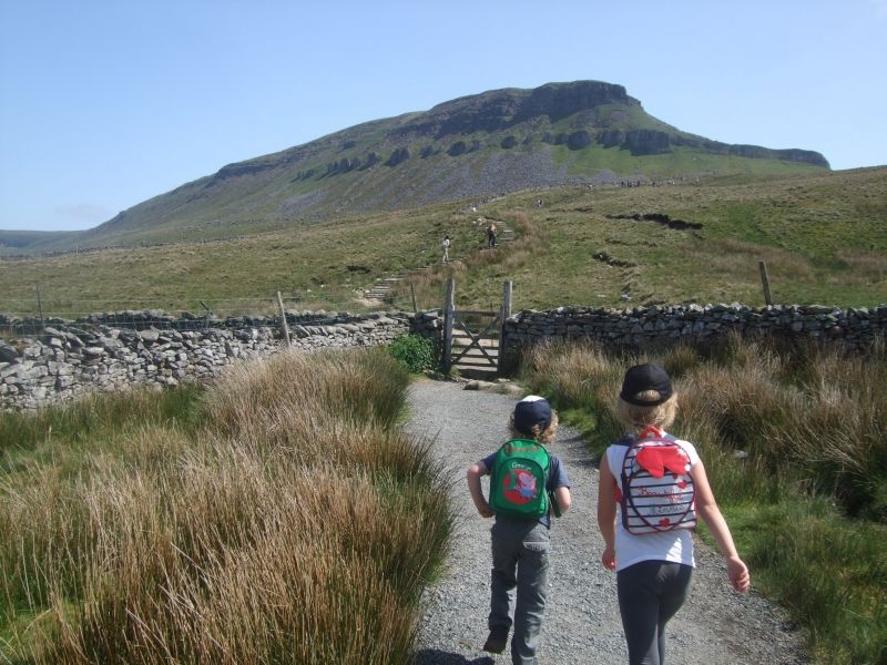
Top of the lane and the gate out onto the fell.
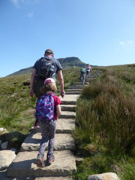
Starting the climb up the fell.
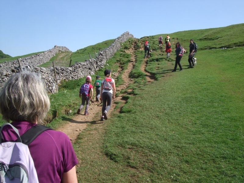
Near the top of the first field.
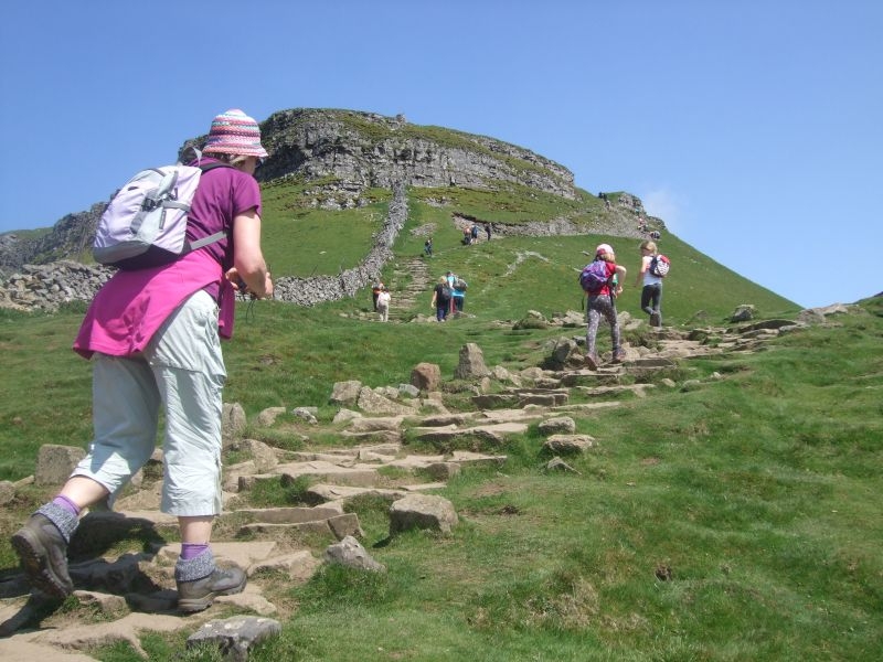
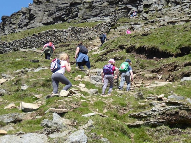
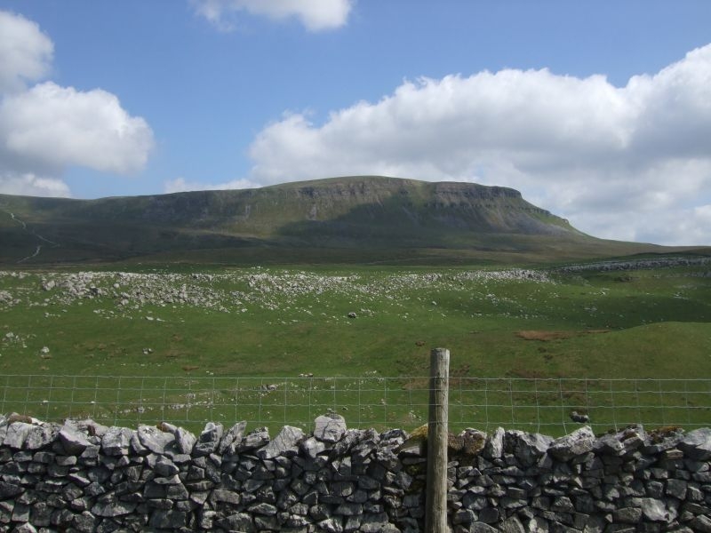
Through the gate and the first view of our target from the path.
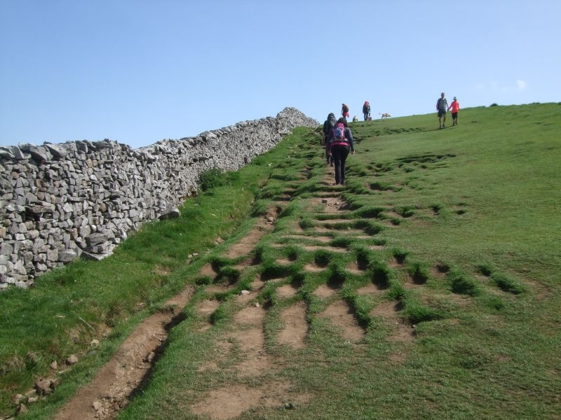
Approaching the first of the limestone outcrops to climb.
Through the limestone.
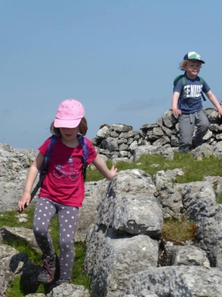
Another scramble to tackle.
Step stile over the wall.
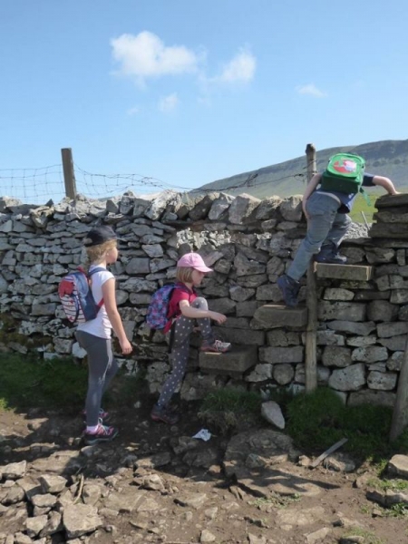
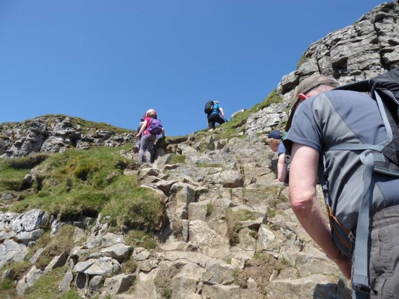
On towards the steps up to the junction with the Pennine Way.
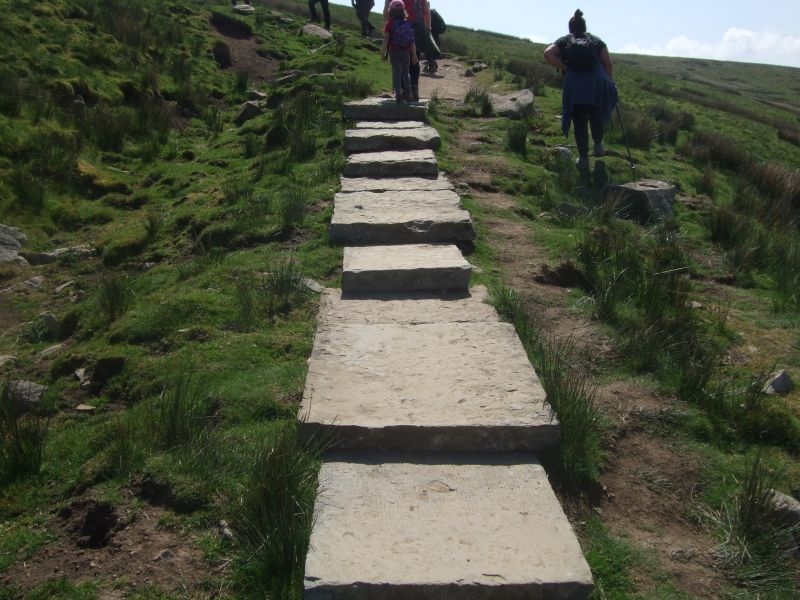
Starting the ascent up the steps, this part of the route used to be wooden staging but was replaced with recycled flags which are more in keeping with the terrain.
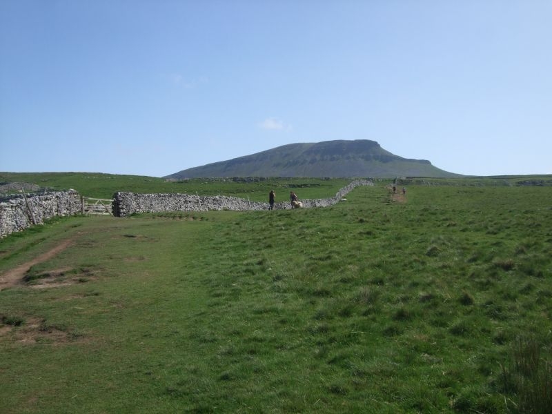
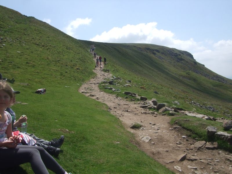
At the top of the steps there is a gate out onto the brow of Penyghent where the path joins the Pennine Way. This is where the last push to the summit starts so is a good place for a break before starting the climb.
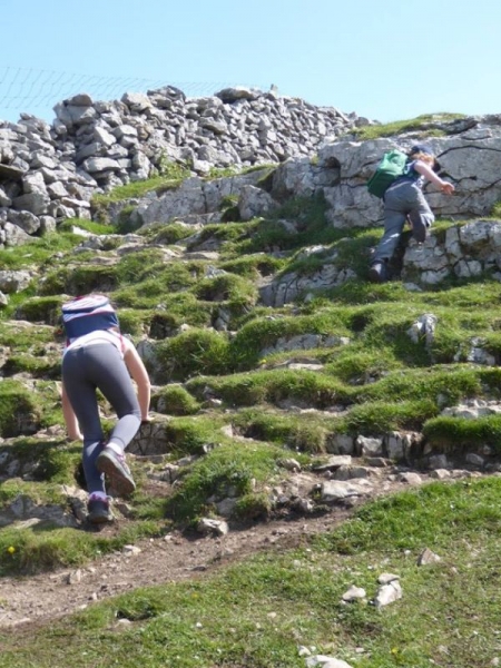
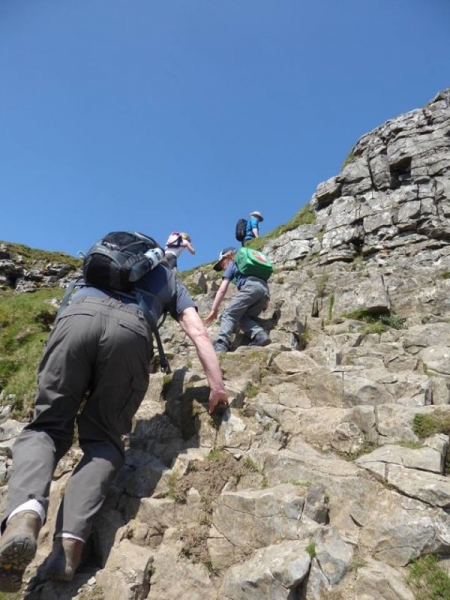
The path rises sharply from here.
It becomes quite narrow as it skirts it way up to a small plateau before the final rocky climb.
Another breather after this first stage climb before the final push.
The last climb up the next 100 ft or so winds its way up the grit stone cap of the hill.
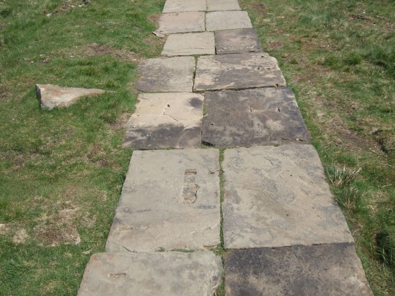
After the last rock climb you emerge onto the final path up to the summit. It used to be very boggy here but the route has now been paved with more recycled stone. You can see where some of these flags originated, fixing points for looms.
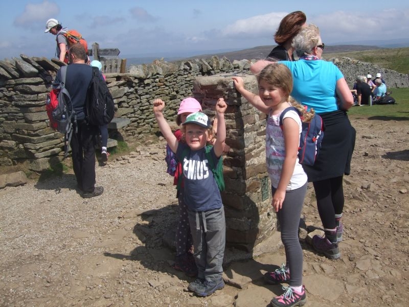
Trigged out about one and half hours after setting off, time for a sit down and our pack up.

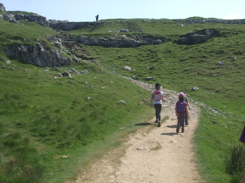
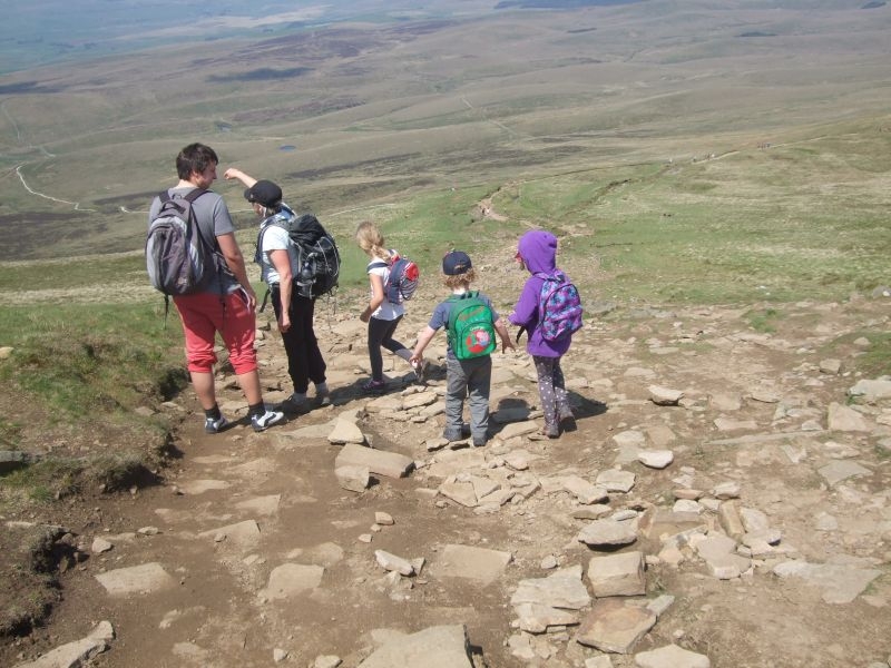
We spent about 20 minutes on the top eating our lunch and to rest the legs up a bit ready for the descent. Over the stile still on the Pennine Way route and starting our descent to the limestone cliff.
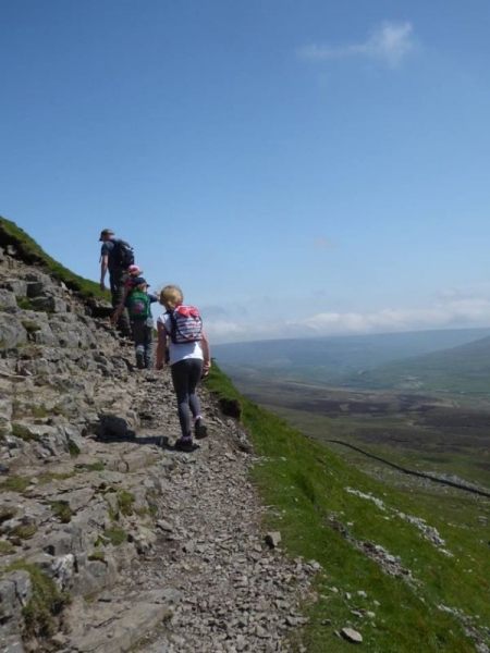
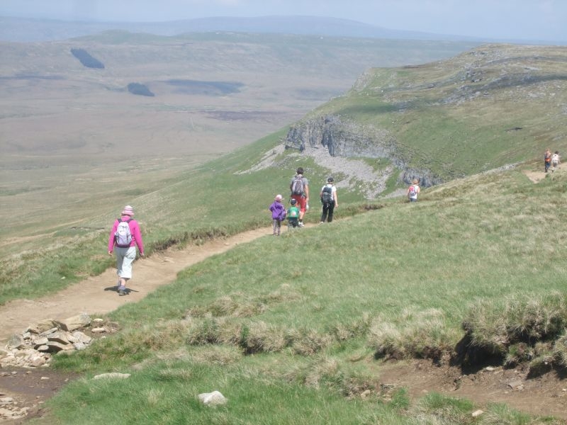
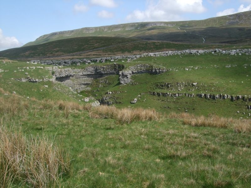
Its downhill all the way from here, the path hugs the side of the hill on its way down to the cliff which you can see in the distance.
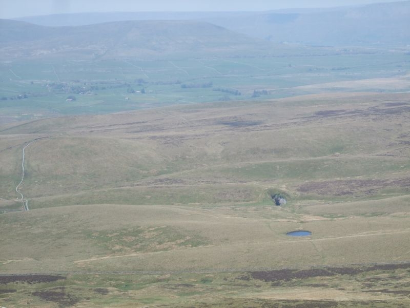
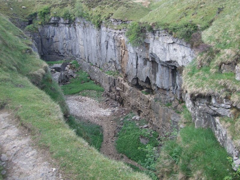
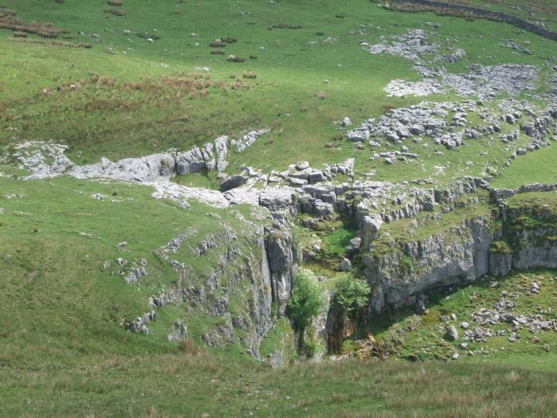
Another feature we will visit on our return to Horton, Hull Pot visible past the waterlogged sink hole.
Limestone cliff in sight.
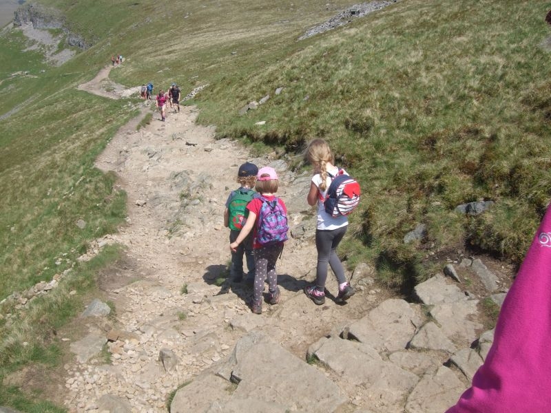
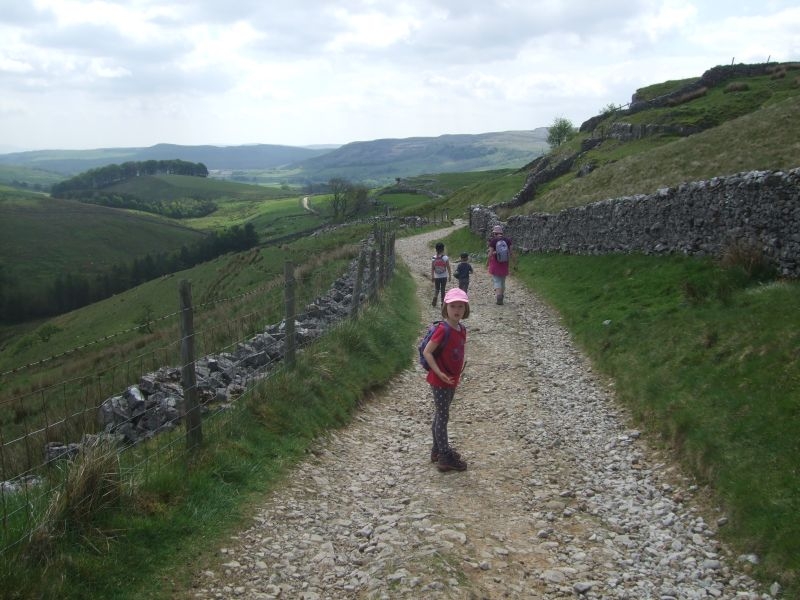
We have another short break here, the kids are doing OK, they are carrying all their own stuff and have not complained at all. Short breaks to keep them going seems to be working well. We still have provisions to munch when needed and water to re hydrate. This is the view back up the path from the summit.
The path descends to the valley floor to join the lane down into Horton. We walked the quarter mile or so back up the valley to show the kids Hull Pot.
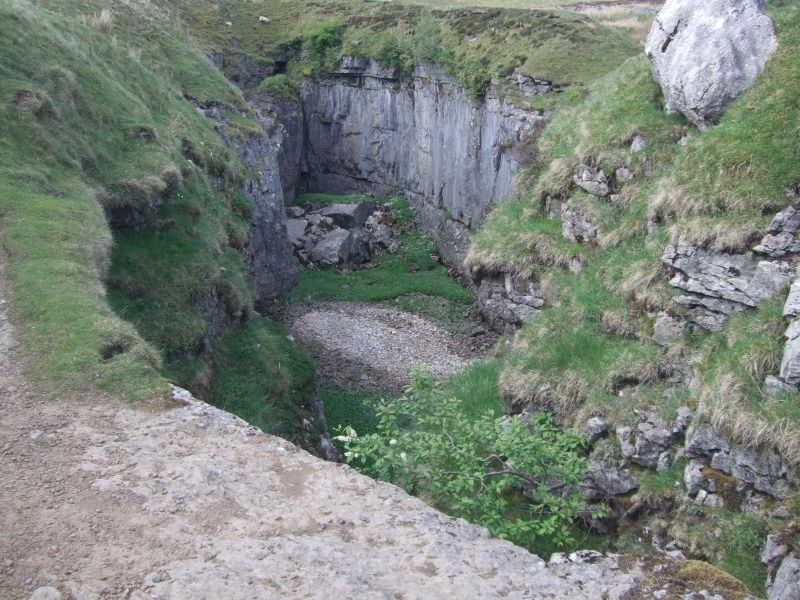
Hull Pot is a massive collapsed cavern the pot itself is still accessible at one end of the chasm floor. Potholers set up ropes to get down to the entrance. Hull pot beck runs over the lip and into the chasm about a third of he way along its length. It has been known in times of extreme rainfall for the chasm to fill completely with water overwhelming the pot below and overflow down the lane. I think the last time was in the 1980's, there are photo's in the Penyghent Cafe. It nearly overflowed this last winter, with the prolonged rainfall that we had. Hull Pot Beck is as dry as a bone today though only a trickle flowing lower down the chasm wall and away into the pot.
We retrace our steps to pickup the Pennine Way again and the lane down into the village.
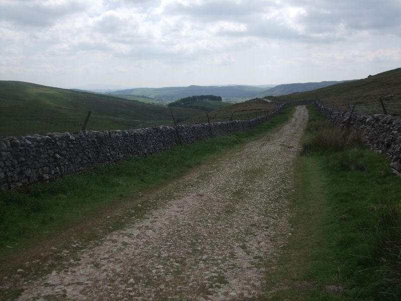
Horton Scar Lane runs parallel to this dry valley.
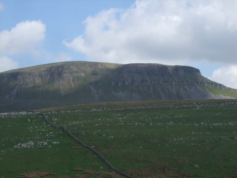
A view back up to Penyghent from the lane you can just see the path down from the limestone cliff.
More of the dry valley.
Only a mile or so to go.
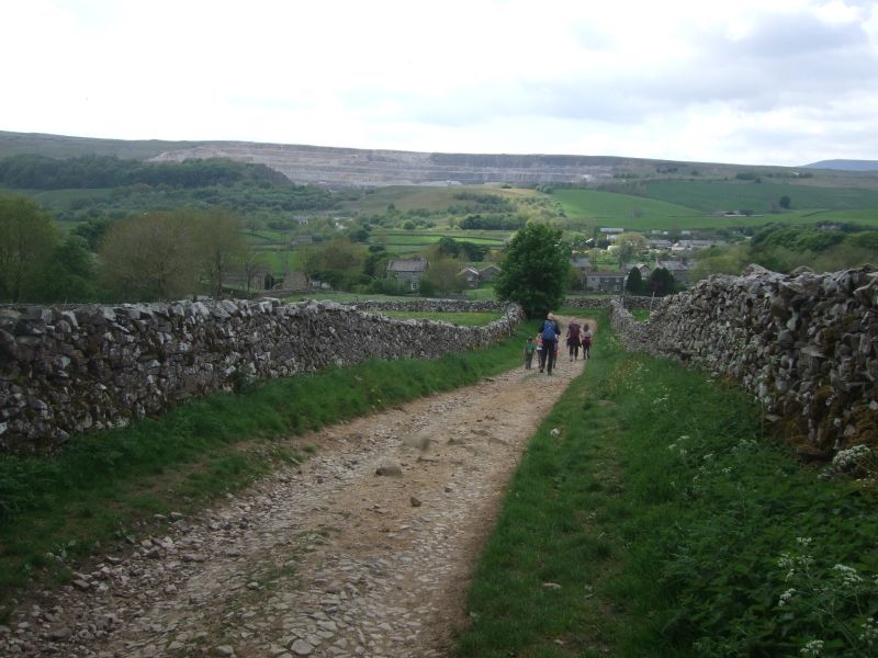
Another view of the hill as we approach Horton.
Rooftops and cottages in site so not far now.
You know you are back in Horton when you see the squirrel.
We went back down to the car and dumped all our stuff, boots off, sandals and trainers on and then back up to the Penyghent Cafe for a brew and ice creams. A guy came in while we were waiting to be served asking for his card for the clocking in machine that they maintain at the cafe for those doing the Three Peaks, he had just completed running the circuit. The cafe runs the Three Peaks club which you qualify for if you complete the 24 mile circuit of the summits of Penyghent, Whernside and Ingleborough in less than 12 hours. You can ask for a card either over the counter or, if setting off early (as most do) with a note through the door with your details on. They will manually enter the time against your name and you can punch it out when you get back. It acts as a safety system as well for the long distance route.
Proud to say both Sally and myself and all three of our kids have done the challenge, Sally and I completed in 10 hours, we were a bit younger though when we did it the first time. Hoping the grandchildren will take it on as well when they get a bit older.
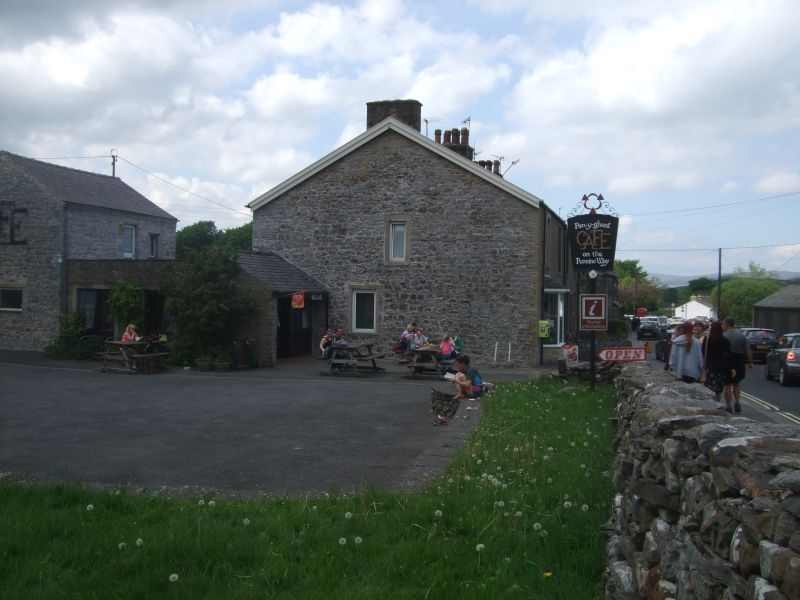
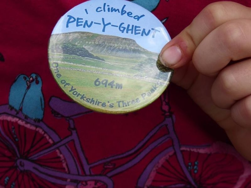
In the meantime for those in waiting to join the club we treated them to a badge apiece to signify their first ascent. Penyghent is a proper mountain.
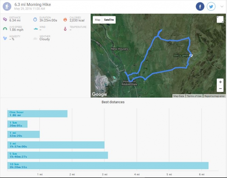
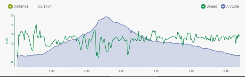
Here is the track and the stats for the day. I have had to hack it a bit as my endomondo did not track the route properly. I don't think it had acquired enough satellites to start the trace when we set off. I have manually drawn the route in and copied the bottom of Sally's track to get the terrain readout.
Anyway, 6.34miles, 3h 25min activity (not including rests), 1257ft total ascent, a lot of calories earned. Dry, warm, sunny day.
Over the road and through the gate to take us to the meadow path.
Gate through to Brackenbottom.
Brackenbottom Lane.
Top of the lane and the gate out onto the fell.
Starting the climb up the fell.
Near the top of the first field.
Through the gate and the first view of our target from the path.
Approaching the first of the limestone outcrops to climb.
Through the limestone.
Another scramble to tackle.
Step stile over the wall.
On towards the steps up to the junction with the Pennine Way.
Starting the ascent up the steps, this part of the route used to be wooden staging but was replaced with recycled flags which are more in keeping with the terrain.
At the top of the steps there is a gate out onto the brow of Penyghent where the path joins the Pennine Way. This is where the last push to the summit starts so is a good place for a break before starting the climb.
The path rises sharply from here.
It becomes quite narrow as it skirts it way up to a small plateau before the final rocky climb.
Another breather after this first stage climb before the final push.
The last climb up the next 100 ft or so winds its way up the grit stone cap of the hill.
After the last rock climb you emerge onto the final path up to the summit. It used to be very boggy here but the route has now been paved with more recycled stone. You can see where some of these flags originated, fixing points for looms.
Trigged out about one and half hours after setting off, time for a sit down and our pack up.
We spent about 20 minutes on the top eating our lunch and to rest the legs up a bit ready for the descent. Over the stile still on the Pennine Way route and starting our descent to the limestone cliff.
Its downhill all the way from here, the path hugs the side of the hill on its way down to the cliff which you can see in the distance.
Another feature we will visit on our return to Horton, Hull Pot visible past the waterlogged sink hole.
Limestone cliff in sight.
We have another short break here, the kids are doing OK, they are carrying all their own stuff and have not complained at all. Short breaks to keep them going seems to be working well. We still have provisions to munch when needed and water to re hydrate. This is the view back up the path from the summit.
The path descends to the valley floor to join the lane down into Horton. We walked the quarter mile or so back up the valley to show the kids Hull Pot.
Hull Pot is a massive collapsed cavern the pot itself is still accessible at one end of the chasm floor. Potholers set up ropes to get down to the entrance. Hull pot beck runs over the lip and into the chasm about a third of he way along its length. It has been known in times of extreme rainfall for the chasm to fill completely with water overwhelming the pot below and overflow down the lane. I think the last time was in the 1980's, there are photo's in the Penyghent Cafe. It nearly overflowed this last winter, with the prolonged rainfall that we had. Hull Pot Beck is as dry as a bone today though only a trickle flowing lower down the chasm wall and away into the pot.
We retrace our steps to pickup the Pennine Way again and the lane down into the village.
Horton Scar Lane runs parallel to this dry valley.
A view back up to Penyghent from the lane you can just see the path down from the limestone cliff.
More of the dry valley.
Only a mile or so to go.
Another view of the hill as we approach Horton.
Rooftops and cottages in site so not far now.
You know you are back in Horton when you see the squirrel.
We went back down to the car and dumped all our stuff, boots off, sandals and trainers on and then back up to the Penyghent Cafe for a brew and ice creams. A guy came in while we were waiting to be served asking for his card for the clocking in machine that they maintain at the cafe for those doing the Three Peaks, he had just completed running the circuit. The cafe runs the Three Peaks club which you qualify for if you complete the 24 mile circuit of the summits of Penyghent, Whernside and Ingleborough in less than 12 hours. You can ask for a card either over the counter or, if setting off early (as most do) with a note through the door with your details on. They will manually enter the time against your name and you can punch it out when you get back. It acts as a safety system as well for the long distance route.
Proud to say both Sally and myself and all three of our kids have done the challenge, Sally and I completed in 10 hours, we were a bit younger though when we did it the first time. Hoping the grandchildren will take it on as well when they get a bit older.
In the meantime for those in waiting to join the club we treated them to a badge apiece to signify their first ascent. Penyghent is a proper mountain.
Here is the track and the stats for the day. I have had to hack it a bit as my endomondo did not track the route properly. I don't think it had acquired enough satellites to start the trace when we set off. I have manually drawn the route in and copied the bottom of Sally's track to get the terrain readout.
Anyway, 6.34miles, 3h 25min activity (not including rests), 1257ft total ascent, a lot of calories earned. Dry, warm, sunny day.
Ian
-
Stanley
- Global Moderator
- Posts: 90300
- Joined: 23 Jan 2012, 12:01
- Location: Barnoldswick. Nearer to Heaven than Gloria.
Re: Favourite Walks and Rambles
I told you the name would come to me, Duxbury.
Nice day on the hill.....
Nice day on the hill.....
Stanley Challenger Graham
Stanley's View
scg1936 at talktalk.net
"Beware of certitude" (Jimmy Reid)
The floggings will continue until morale improves!
Stanley's View
scg1936 at talktalk.net
"Beware of certitude" (Jimmy Reid)
The floggings will continue until morale improves!
Re: Favourite Walks and Rambles
That looks like so much fun. Nice walk...I would be fine with that one ( hubby may need to stop now and then on the steeper bits and wait for his circulation problems to right themselves).
The kids look like little treasures. All that way without a grumble...well done!
Beautiful countryside - stunning.
The kids look like little treasures. All that way without a grumble...well done!
Beautiful countryside - stunning.