Page 121 of 277
Re: FORGOTTEN CORNERS
Posted: 03 Jan 2018, 10:31
by Tizer
Hooper would have had a surprise if he'd counted the species in the laneside hedge at our previous house. We kept adding species and it ended up with about 20 species, native and ornamental, in about 60 foot of hedgerow. We cheated!
Re: FORGOTTEN CORNERS
Posted: 05 Jan 2018, 05:35
by Stanley
Ah, his law does allow for introduced species and was never any better than a very rough estimate. There is usually complimentary evidence in the associated history. I've always found it to be a useful indicator and when you get the same result for other similar hedges you can start to build up confidence in your observations. Corroboration is a very useful research tool! [But you knew that.....]
Re: FORGOTTEN CORNERS
Posted: 06 Jan 2018, 06:38
by Stanley
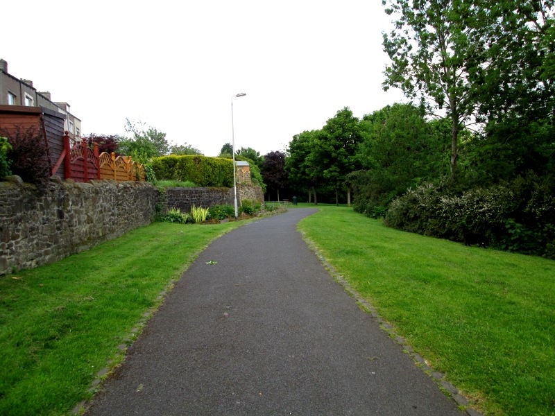
Some things are so familiar they become forgotten corners. A good example is Valley Gardens and I walk through it every morning. I have never dug into the origins of the present park but suspect that when the BUDC bought the Corn Mill they found they were the proud owners of a strip of land up to Butts. When William Bracewell bought the mill in the 1850s and enlarged the dam he would also pay attention to the source of the water and the course of the mill race that ensures that the water level in the dam was high enough to give a useful fall at the mill to run the wheel and the later turbine. If the course of the race wasn't already part of the mill curtilage he would have bought the land round it for security. The course of the original race is preserved in the park in the form of a drain and an open stretch of stream but instead of going forwards under the road through a culvert into the dam, it is diverted back into the beck inside the park, the point of diversion is the lamp post on the left. How many people realise this and know the history?
Re: FORGOTTEN CORNERS
Posted: 07 Jan 2018, 04:55
by Stanley
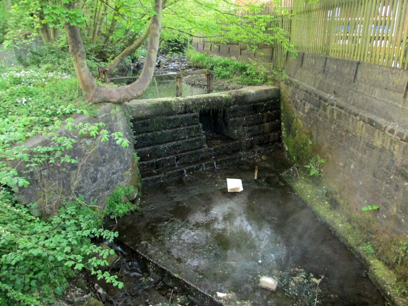
The key to the water power at the Corn Mill, the dam in Butts behind the old Model Lodging House from which the Corn Mill race starts. I usually show pics of it with a good flow of water but on this day the flow in the beck was very low, so low that leakage between the massive stones of the structure coped with the flow. To most people this will be 'the waterfall in Butts' and they will have little or no idea of its importance. Because I have spent so long looking at water power sites I see it differently and always assess the flow from the miller's point of view. This was a bad day!
One thing that isn't generally recognised is that the miller's dilemma was that in winter when the flow was most useful and constant, the light was low and he had the expense of candles to light the mill. This is a much bigger problem than you might think, candles were expensive and profits slender. Look for 'A Calendar of Lancashire Documents' on the site and you'll find mill accounts that show just how big an expense this was. This 'waterfall' was crucial! Now, it's a forgotten corner.....
Re: FORGOTTEN CORNERS
Posted: 07 Jan 2018, 09:04
by Wendyf
Our History Society has just been given a bundle of documents which includes a 1743 account book for Earby corn mill. We haven't had time to study it in any depth yet but it's a thrilling discovery!
Re: FORGOTTEN CORNERS
Posted: 08 Jan 2018, 04:31
by Stanley
You can get a lot of information from them Wendy. One thing that you might find interesting is how much malt they sold for home brewing.
Re: FORGOTTEN CORNERS
Posted: 09 Jan 2018, 05:07
by Stanley

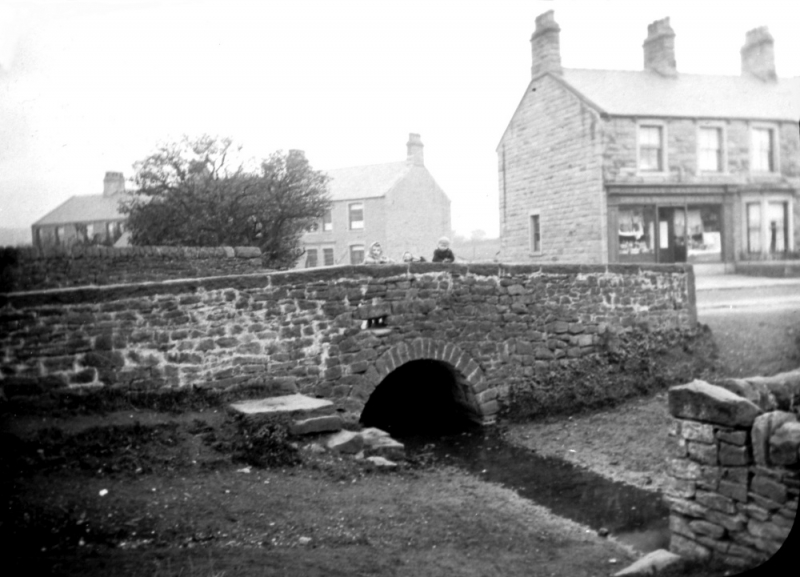
This old image has always intrigued me. It's on Butts Beck in what is now Victory Park looking back towards the Corn Mill. As near as I can reckon it's around 1890. Not the clearest of images but if you look carefully you'll see there is a single slab of stone laid across the beck as a foot bridge.
Not what you'd call earth shaking but it's a reminder of the days when foot traffic was the only way you got from place to place in the town and for some reason this footpath was important enough to go to the considerable trouble of sourcing this big slab, transporting it and placing it across the beck. I have no idea what this reason was, there is nothing obvious.
Re: FORGOTTEN CORNERS
Posted: 09 Jan 2018, 13:12
by PanBiker
Stanley wrote: ↑09 Jan 2018, 05:07
This old image has always intrigued me. It's on Butts Beck in what is now Victory Park looking back towards the Corn Mill. As near as I can reckon it's around 1890.
A lot of assumptions here Stanley, are you certain it is that location?
On the 1907 15" to the mile map there are three crossings shown on the beck. All as they are now, two below Barnoldswick Mill (as shown on the map) one of which is in the mill yard and used to give access to where the second gasometer used to be (allotment land at the time) and the other on West Close, the third is at the bottom of Crow Nest where Crow Nest Syke runs in. All these crossing points have footpaths adjoining. The retaining wall looks to be wrong unless it has been very much reduced in size in later years.
Re: FORGOTTEN CORNERS
Posted: 09 Jan 2018, 16:52
by Wendyf
It's a bit cheeky to call him a forgotten corner but I've just spoken to Ted Harrison on the phone about his history society subs, he is sounding very chipper for a 92 year old! Ted was a regular contributor to the site in the early days.

Re: FORGOTTEN CORNERS
Posted: 10 Jan 2018, 03:32
by Stanley
Not assumptions, based on what's in the picture and the original is slightly better than the image on site. Roughly in line with where the Crow Nest lodge is at the back of the mill.
I remember Ted well Wendy! Nice to hear he is still batting. Ten years older than me.....
Re: FORGOTTEN CORNERS
Posted: 10 Jan 2018, 12:16
by PanBiker
So the retaining wall has to be the one that is now on the park side, the height of the wall is about half that now. If correct the bridge has to be at West Close there are no others on the map. The mill looks further into the distance to me and if it was the footbridge lower down at Crow Nest there would be a bend in the beck. Still not convinced but hey ho.
On the 1907 map The road at West Close terminates at the crossing point and turns left into the mill yard. The other side of the bridge has a footpath over open fields as was then. This looks like the line of the path between the hen pens now. China Town was not yet built so all open fields down to the Syke.
Re: FORGOTTEN CORNERS
Posted: 11 Jan 2018, 04:41
by Stanley
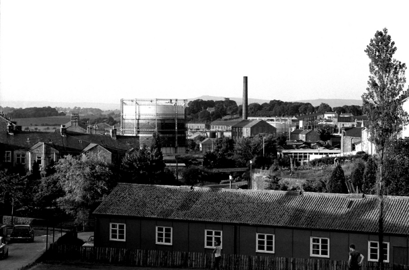
It's amazing how things change so quickly. This was a snap in 1982 of the same area from the opposite direction. It's changed completely, no gas holders and lots more trees.
Re: FORGOTTEN CORNERS
Posted: 11 Jan 2018, 10:05
by PanBiker
In the original photo what is the building directly above the footbridge? The stack looks to be too far to the left to be where the mill stack was I can remember where that was from when I was a lad, it was in front of Cornmill Terrace, there's a house on the site now. In the later picture the stack is at Crownest which wasn't built at the time of the first picture and would have been behind the viewpoint anyway.
Re: FORGOTTEN CORNERS
Posted: 12 Jan 2018, 05:08
by Stanley
Looks like the Corn Mill and the stack to the left would be Wellhouse. Sometimes the characteristics of the old lens distorts orientations.
Re: FORGOTTEN CORNERS
Posted: 13 Jan 2018, 03:50
by Stanley
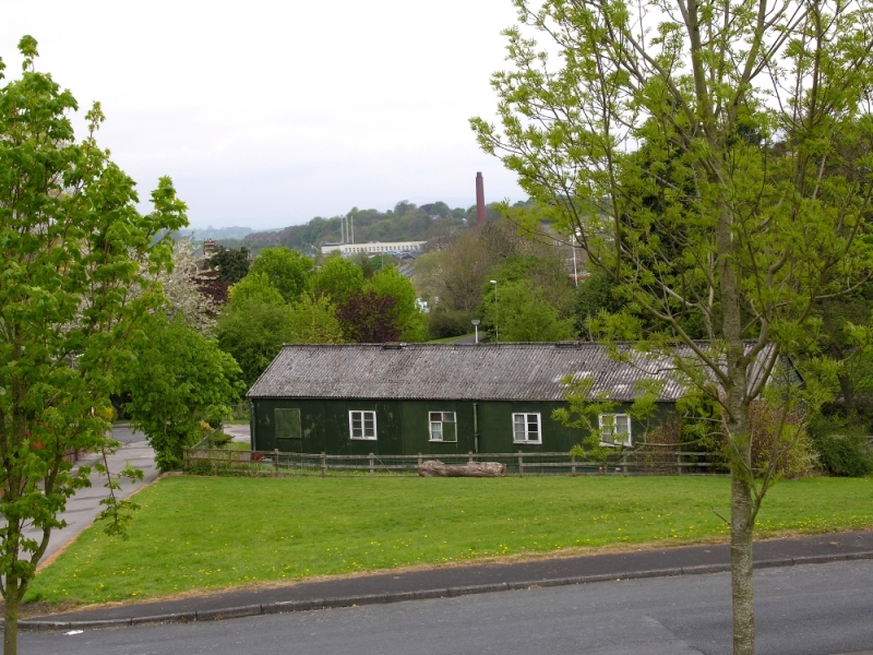
Repeat of the gasworks pic in 2010.
Re: FORGOTTEN CORNERS
Posted: 14 Jan 2018, 05:10
by Stanley
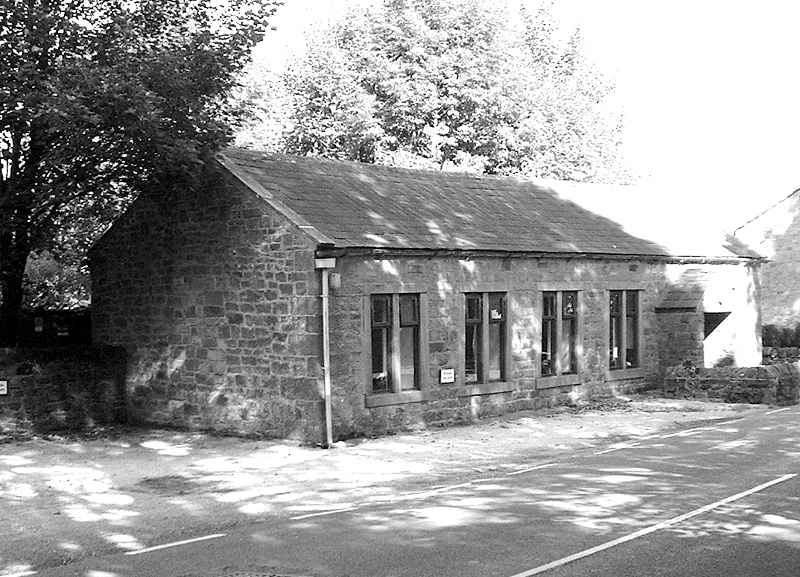
You will all recognise this I think. The Village Institute at Bracewell. What some of you might have forgotten is that originally it was Bracewell School. If you are interested, go to the LTP and look at Harold Duxbury's evidence, he attended the school as a lad and tells us that the teacher lived in Barlick and went down every day in all weathers. She must have done something right! Harold was certainly a credit to his early education.
Re: FORGOTTEN CORNERS
Posted: 15 Jan 2018, 04:44
by Stanley
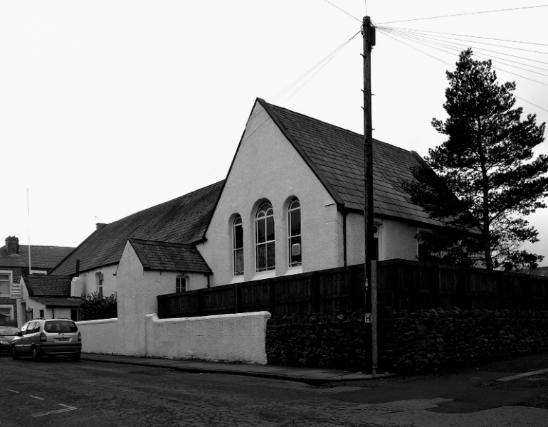
This building in Fountain Street is a nursery school now. It started life as the 'Brick School' built by Billycock Bracewell and had a variety of uses including being the social club for Ouzledale Foundry for many years.
Re: FORGOTTEN CORNERS
Posted: 15 Jan 2018, 07:06
by Nolic
It was a good social club. Played there a few times in the early '80's with Streetlife. Nolic
Re: FORGOTTEN CORNERS
Posted: 15 Jan 2018, 08:02
by Marilyn
I was born just across the road! fountain Street.
Re: FORGOTTEN CORNERS
Posted: 16 Jan 2018, 05:05
by Stanley
That's right Maz! And I think that once it was HQ for the Barlick Brass Band.
Re: FORGOTTEN CORNERS
Posted: 17 Jan 2018, 05:02
by Stanley
The bridge over the beck at Salterforth on the road from the village up the Drag onto the top road in about 1900. This was before the New Road was built and you had a choice if you wanted to get to Barlick, you either went this way up the hill but on a good road or you chose Cross Lane to Coates which was badly maintained.
Re: FORGOTTEN CORNERS
Posted: 18 Jan 2018, 04:26
by Stanley
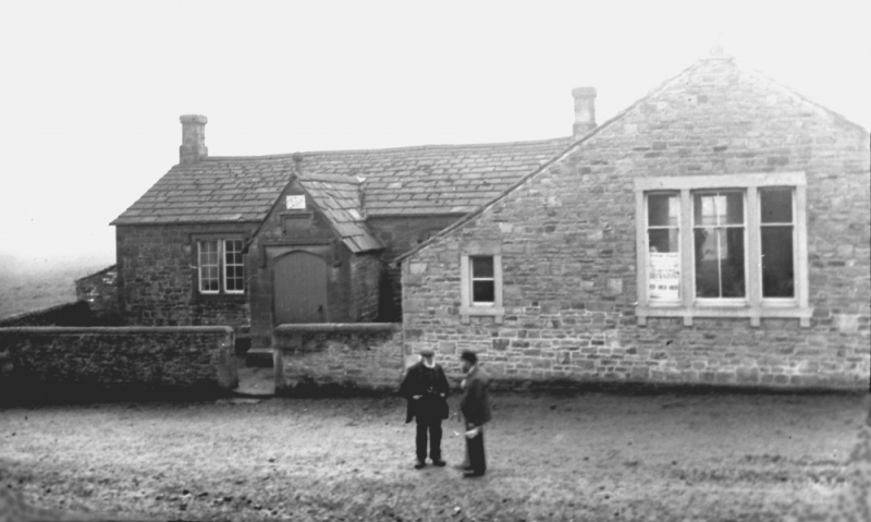
Salterforth school in about 1890, it looks as though it had already been extended by then. It's a private residence now.....
Re: FORGOTTEN CORNERS
Posted: 19 Jan 2018, 05:15
by Stanley
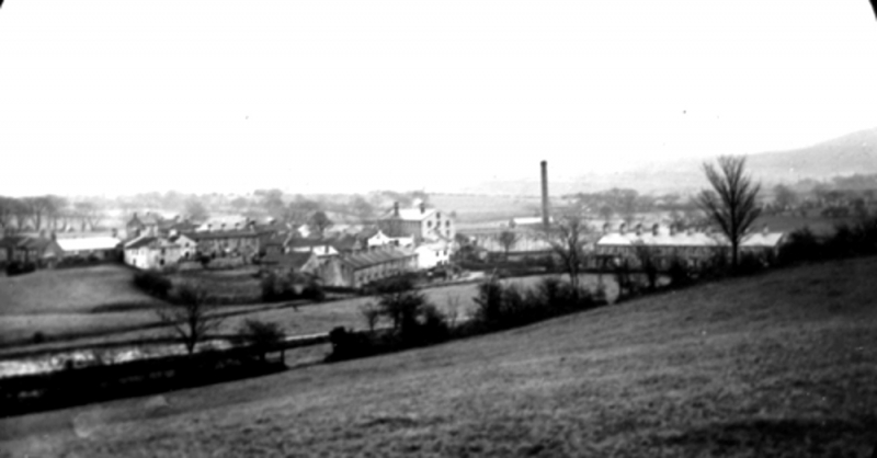
An old image of Salterforth in 1890/1900 when it still had a mill chimney. Before the advent of the railway Salterforth was vital to Earby as the wharf was the source of the coal supplies for the early steam mills in Earby. There must have been a constant stream of two wheeled carts carrying about two tons of coal each and lots of work for the carters.
Re: FORGOTTEN CORNERS
Posted: 20 Jan 2018, 05:12
by Stanley
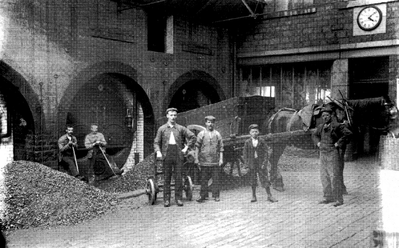
A typical two wheeled coal cart of the period. Worth remembering the infrastructure that lay behind the use of these carts. Horses to be bred and reared, hay and straw to be provided and manure disposed of. Stables were needed and cart-builders and blacksmiths. Then there was the employment for loading the carts and the carters themselves. Even after the railways delivered coal into town centres the coal had to be transported to the mills. The streets must have been very busy because in addition to the coal carts there was all the other horse transport, remember that we had a thirty year building and public works boom and all the materials had to be delivered.
Re: FORGOTTEN CORNERS
Posted: 21 Jan 2018, 04:55
by Stanley
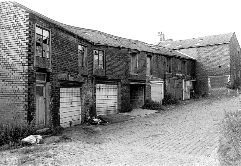
These old stables in Butts, snapped in 1982 and since demolished, were a busy corner every working morning and on Sundays as well of course, you can't switch horses off! There were market gardens next to them and I think a lot of the muck must have gone there. Good recycling of the hay and straw.