We set the scene for our enquiry into Barlick transport last week when we looked at the general history of goods carrying over the whole of England. Looking at Barlick, we should perhaps start by looking at the routes. Notice that I haven’t said roads, the concept of a road as we understand it didn’t appear until the 17th century and even then, only for major routes between cities. Before this, the only paved ways that existed were the remnants of the roads the Romans made in the 500 years of their occupation. Not surprisingly these had deteriorated to the extent that in many cases it wasn’t possible to see that a metalled road had ever existed. It wasn’t until the late eighteenth century and the advent of the local turnpike trusts that any serious effort was put into making ways fit to carry wheeled vehicles between towns.
Going back even further to say 2000BC, all traffic was carried on human backs because there were no draught animals. Oxen didn’t become common until well into the Dark Ages after the Romans had left and horses were an exclusively noble animal until probably the mid 16th century. This traffic needed nothing more complicated than a passable footway. The first trackways were simply routes between adjoining farmsteads. This explains the seemingly random paths they followed winding about in the most unexpected way. This was because they followed the boundaries of existing holdings or field systems.
We can still see examples of this inside the township of Barlick itself. Stand at the top of Esp Lane at Townhead and see how the old medieval road winds its way through the houses and then takes a couple of bends before it straightens out up the hill towards Hill Clough. All these deviations are a marker to where the boundaries of landholdings were long before the Norman Conquest. There is an exception in Barlick, an ancient route that is as straight as a die. This is Greenberfield Lane and Brogden Lane and they are reasonably straight because they follow the line of the old Roman Road from Ilkley to Ribchester and in the days when they were laid out there were no land boundaries to avoid. So, a good general rule is if the old road is straight it means it was laid out before the landholdings, if it is twisty, it came after.
There is of course one other route which is older by far than the Roman Road. This is the track that comes across the top of Weets from Middop, roughly follows Folly Lane down into the town, crossing the field (Causeway Carr) behind Bancroft, going straight across Forty Steps and up what is now Park Road but used to be called Blue Pot Lane. There is no firm evidence but I believe this was part of a much longer Bronze-Age track running from the coast at Preston straight across England through the Aire Gap at Kildwick. This was a main route for the transport of gold from Ireland to the Baltic states.
Apart from the remains of this trackway and the Roman Road, the town routes were purely for local trade and communication during the period from say 500 to 1600. If you had a surplus of a crop you might swap it for a neighbour’s pig. Perhaps your wife was a good weaver, she could take someone else’s wool and make it into cloth. The only trade from outside the area would be bar iron for tools, perhaps even small tools and needles from Sheffield, salt from Northwich or the coast or spices from a major port. These were all necessary items that couldn’t be made at home. I wonder what was bartered for these things. There was some coinage but most of the trade would be financed with goods in kind. Perhaps it would be cloth or skins, whatever, it had to be a local commodity.
We know that during the 15th century there was a fulling mill at Colne and several clothiers, the people who dealt in wool and woollen cloth, in Colne and Barrowford. We also know that economic circumstances in Barlick were picking up during the same century. The population must have started to rise because by the middle of the 16th century there was enough pressure on the land to make enclosures on the waste necessary. We know this because a map of 1580 shows enclosures at Barlick, Salterforth and Foulridge. This suggests that there was an increase in traffic because there are only two explanations for the better circumstances, a warming of the climate and extra income from a domestic textile industry. Yarn and cloth would be on the move between Colne and Barlick and by that time horses were being used for carrying some of the traffic.
The first firm evidence I have for this is in the Barcroft papers of 1689 to 1732. In these Ambrose Barcroft of Noyna Hall mentions sending up to 50 packs of cloth at a time to Lincolnshire. There are many weights quoted for a ‘pack’ but the most usual, a horse load, was 17 stone and 2lbs; 240lbs or 109 kg. This is where we first meet our ‘broggers’. Wool was one of the most valuable commodities in Tudor England, and the wool trade was controlled by the State. A Brogger was a freelance wool dealer, working without the necessary license. These men were an essential link between small farmers and the mainstream of the wool trade as they bought wool off the farm and sold it to the clothiers who were all licensed as Members of the Staple. In theory they were breaking the law and this was codified by the so-called 'Halifax Act' of 1552 which restricted the dealing in wool to members of the Staple. This was such a blow to the rural economy that it was changed so that in 1555 exemption was given for the wool driver and brogger; in fact they were then established as an essential part of the industry.
SCG/19 September 2005
1011 words
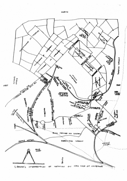
1580 map of Barnoldswick and Salterford. High Lane runs along the top of the ‘improvements’ which are enclosures on the waste.