

One of the questions often asked is how wide the roads were. In the past many historians have started from the Roman roads and assumed that this was some sort of standard. The latest research on Roman roads suggests that they could be any size from eight feet wide and upwards depending on their importance and hence the amount of traffic. However, this applies to what we would now call trunk routes and it would be a mistake to apply this directly to local roads such as the ones we are looking at in Barlick.
In the days before draught animals and wheeled vehicles all the ways we are looking at were footpaths. Look at any footpath on a right of way across a modern field and that’s the scale, just wide enough to walk on. If there was a boggy patch the traffic might by-pass this by walking on the firmer ground and over the years such a path would naturally get wider. Eventually as stock-proof boundaries were needed along the route walls would be built. The path from Esp Lane to Calf Hall Lane over Pickles Hippings is a good example. Where there was an obstacle like the Calf Hall Beck, the most regular users would make things easier for themselves by putting in stepping stones or ‘hippings’. A bloke called Pickles evidently did this on the path at some time.
Notice that the path here is wider than a footway. Evidently it became used as a packhorse way before the walls were built. At some later date it has been paved and the hippings replaced by a bridge. I suspect this is a fairly modern bridge here but if it had been a packhorse bridge there would have been a dead giveaway, the parapets would either have been missing or low enough not to interfere with the packs on the horses backs. The bridge I showed a fortnight ago at Wood End is a good example.
With the advent of wheeled transport the ways would have to have been widened to about nine feet. We have good evidence for this in the Manorial Court Rolls dated 20th October 1763. ‘We the Jurors above named upon our oaths present that from the time whereof the memory of Man is not to the contrary there hath been and still is a common and ancient road lying and being within the jurisdiction of this Court all the lay subjects of our Lord the King to pass & repass on foot and on horse back and with loaded horses to and from the township of Brogden within the jurisdiction aforesaid to and from the ancient and accustomed Mill called Barnoldswick Mill within the jurisdiction aforesaid containing one thousand yards in length and three yards in breadth and that Beatrix Lister widow, Nicholas Winckley, Robert Parker Esq., Edmund Grundy, John Smith, David Blegbrough, Thomas Edmondson and Thomas Hoyle, clerk Rahone Tenurae ought and by custom are want to repair and amend the same when and so often as need shall be as required. And the same road being deep broken and out of repair and for want of the due reparation and amendment thereof that the lay subjects of our said Lord the King cannot on foot, horse back and with loaded horses and other cattle pass go ride and labour at their will and pleasure for the purpose and on the occasion aforesaid without great damage of their loads and the loss of their goods. To the great damage of said common nuisance of our said Lord the King his crown and dignity.’ Notice that the width for this road is specified as ‘three yards’. We can be certain that this was a cart road because it led to the mill.
This is a good indication of the importance of the corn mill and the customary rights which it enjoyed. The persons named are evidently the landowners along the route of the road and it looks as though this includes at least part of what we now know as Calf Hall Lane. It also gives us a clue as to how these customary ways were maintained, it was the responsibility of the landowners through whose land the road passed. Even though the main routes out of the town, ‘The King’s Highway’, were repaired by the Manor, the responsibility for the fences and ditches still fell to the landowners. Manorial Court Rolls 18th October 1743: ‘Several owners and occupiers of land adjoining the highway from Four Lane Ends to Gisburn Lane ordered to repair fences and scour and open ditches within the highway before 11th November 1743. 1/- fine for every rod or perch not done.’ [ A rod, pole or perch was a measure of length and equals five and a half yards.] I’m presuming that ‘Gisburn Lane’ was the road through Bracewell and so this refers to Banks Hill and beyond.
What about the King’s Highway, the main routes out of the town? We’re lucky enough to have a picture of the road on the Skipton side of Coates bridge, this would be taken about 1890 and it shows a road that is approximately nine feet wide but certainly no more. It’s easy to see that this would only be suitable for foot and horse traffic and small carts. Despite this, Richard Ryley noted in his diary entry for March 22nd 1862 that he had gone to Gill Brow to watch twenty one horses and sixty or seventy men dragging the new boiler for Butts Mill into the town. Weighing twenty tons gross, the team of horses and the wagon carrying the boiler must have passed down this narrow road and over the canal bridge. One wonders why it wasn’t brought from Keighley to Barlick on the canal.
So, right up to the middle of the nineteenth century we have a small town served by what was in effect a medieval road system. The growth of the textile industry was to change all this and we’ll have a look at that next week.
SCG/27 September 2005
1021 words
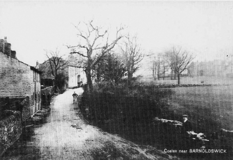
The Skipton side of Coates Bridge in about 1890. Imagine 21 horses dragging a twenty ton load along here!